
-
 13521 Hits
-
 83.69% Score
-
 17 Votes
|
|
Mountain/Rock |
|---|---|
|
|
44.81910°N / 109.3224°W |
|
|
Park |
|
|
Hiking, Scrambling |
|
|
Summer, Fall |
|
|
8633 ft / 2631 m |
|
|
Overview
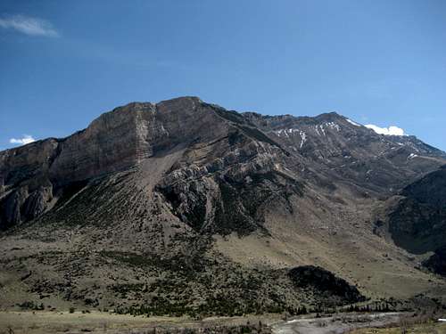 Bald Peak from the north
Attaching the name "Bald" to a mountain, hill, or peak appears to have been a favorite pastime of the people who settled Wyoming, as there are least 34 different places where variations of the name occur in the state. From Bald peaks, mountains, and hills, to Baldy knolls, ridges, knobs, and buttes, the name is everywhere; however, one mountain stands out from the rest due to the fact that it is the only one of the bunch with more than 1,000 feet of prominence. The Bald Peak located just outside of Clark, Wyoming on the south side of the scenic Clark's Fork Canyon is a massive mountain that is visible from much of the Big Horn Basin. A gentle ridge leads up to the top from the south, while the east, west, and north sides drop more than 4,000 feet to the surrounding areas below. The views of Sunlight Basin and the nearby peaks in the Northern Absaroka Range are very beautiful and make the trip to the summit definitely worth your time.
Reaching the top from the south ridge is a relatively easy proposition in the summer and fall if you have a 4WD vehicle with high clearance, and can be done in a just a few hours. However, during other times of the year, it is a much more difficult undertaking due to the seasonal closure of the Bald Ridge Road, requiring a choice between a 7-mile approach or a slightly shorter scramble up 4,000 feet on the east side.
Summit Views
 Looking over Sunlight Basin into the heart of the Northern Absaroka Range
 View over the mouth of the Clark's Fork Canyon to Clark, Wyoming
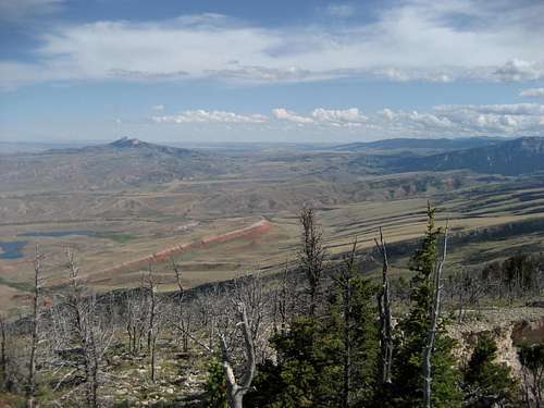 Looking southeast over Hogan and Luce Reservoirs to Heart Mountain
 View across the canyon
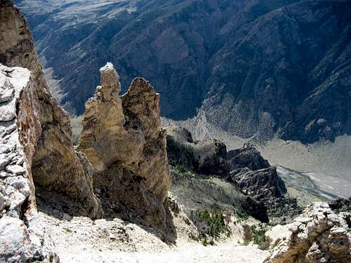 The drop down the west face of 4,000 feet
Getting and Climbing Information
From Cody, WY, take Highway 120 north for almost 17 miles and turn left on the Chief Joseph Scenic Highway. After driving for about 11 or 12 miles on this road, you will pass the turnoff to the Northwest College Field Camp; look for a dirt road that turns off to the right three quarters of a mile past this point. This is Forest Road 100, also known as Bald Ridge Road, and it is seasonally closed from late fall to mid or late May. The road passes through two gates (please close them behind you) as it heads north for about 5 or 6 miles. There are a few forks and it is pretty easy to find your way, but it wouldn't be a bad idea to have a topo map with you to make sure you stay on the correct road. The road deteriorates considerably after the fork 5 miles down the road; take the right turn and drive as far as you feel comfortable before parking. Bald Peak from the ridge road
 Approaching the summit
From here, walk northwest to the ridge and follow it for 1.5 or 2.0 miles to the top, depending on where you parked. The first section of the hike heads through a sparsely forested area before entering a stark landscape of dead trees. The trees cover much of the eastern slopes of the mountain below the summit, and are not difficult to hike through; there are several places along the ridge that provide breathtaking views down into the canyon to the west. The summit is a small rock outcrop with a little exposure on the west side that provides the opportunity for some fun scrambling if you are bored with the flat terrain.
Reaching the summit of Bald Peak via the Bald Ridge Road is hike of about 1.5 miles and 1200 feet of elevation gain. If you take this route when the road is closed, the hike is about 7.5 miles with the same amount of elevation gain.
 Late summer wildflowers
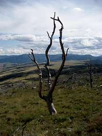 Bald tree
Another way to the top is described in Bill Hunger's book Hiking Wyoming. From Cody, travel 18.5 miles north on Highway 120, turn left on County Road 7RP, and follow the signs to Hogan and Luce Reservoirs. From the trailhead a trail leads generally northwest for 5 miles, ending at the National Forest boundary near the ridge. According to the book, the upper portions of the trail are not marked or constructed, making it more of a scramble up the slopes.
The Hogan/Luce route on Bald Peak is a journey of 5-6 miles with over 4000 feet of elevation gain.
Red Tape/Camping
The summit and western side of this mountain lie with the Shoshone National Forest, but the eastern slopes are on BLM land. There are no fees required to hike in or use this area. Camping is not really an issue on this climb, but if you want to do it, know the rules for both land agencies (information can be found on the links below). Bald Ridge Road is a popular area for hunters, so be sure to wear bright colors if you hike here during hunting season. Bald Peak summit
External Links
Shoshone National ForestBLM