
-
 8252 Hits
-
 80.49% Score
-
 12 Votes
|
|
Mountain/Rock |
|---|---|
|
|
42.62644°N / 0.41353°E |
|
|
Mountaineering, Scrambling |
|
|
Spring, Summer, Fall |
|
|
10016 ft / 3053 m |
|
|
Overview


The three peaks of Eriste or Bagüeñola are the Eastern summits of massif of Posets. They are very individualized and each peak has independent route with possible trailheads in Viadós or Puerto de Sahún. The routes are always long and for this reason many mountaineers climb only 1 or 2 peaks in one day returning another day to the other peak or peaks. The trained mountaineers can climb the three peaks of Eriste in the same day in a long route of more than 11 or 12 hours of walking in a beautiful but hard place normally without path in the access to the summits.
The three peaks of Eriste:
-Eriste Sur or Bagüeñola Sur (3.045m)
-Eriste Central, Bagüeñola central or Gran Eriste (3.053m)
-Eriste Norte, Bagüeñola Norte or Pico Beraldi (3.025m)
The distance between the peaks are about 450m or 550m and you must descent generally across its normal routes to walk to the following peak because the ridge is very hard (AD with bad rock). The time to climb another peak is about 1 hour more. For the moment I think that’s a better option to make a page of the three peaks writing detailed information of the climb of each one in the route section. The climbs are not difficult but all has own route and some rock-climbs only for mountaineers (F, F+ or PD-). The hikers can visit the beautiful lakes of Barbarisa or Ribereta but the climb is hard for them.
The name: the people of East side use the name Picos de Eriste because they're over the village of Eriste. The people of west side in the villages around Plan use the name Picos de Bagüeñola. Both names are corrects but the most popular is Eristes.
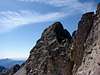
Eriste Sur (3.045m)
 From Gran Eriste
 From Eriste N.
Also named Bagüeñola Sur.
Routes:
-Puerto de Sahún-collado de la Ribereta (F.): 4h 30m
-Eriste (F.): 6h


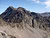
Gran Eriste (3.053m)
 SE face
 From North
Also named Eriste Central or Bagüeñola Central.
Routes:
-Puerto de Sahún-collado de la Ribereta (F+): 4h 30m
-Puerto de Sahún-coulouir de Bagüeña (P.D.): 4h 45m
-Puerto de Sahún-Ibon Chelau-brecha Eriste Sur/Central (F+): 4h 45m.
-Eriste (F+): 6h
-Viadós-Lago Leners-ridge NNW (P.D.-): 4h 25m
-Viadós-Ibon inferior de Millares-North face (P.D.): 4h 25m


Eriste Norte (3.025m)
 SE face
Also named Bagüeñola Norte or Pico Beraldi.
Routes:
-Puerto de Sahún-collado de la Ribereta-ridge NE (F+): 5h
-Viadós-collado de Millares-ridge NE (F+): 4h 25m
-Eriste-ridge NE (F+): 6h

Getting There
Puerto de Sahún:The approach is the same of the village of Benasque:
-From Zaragoza to Huesca (72 km), highway. From Huesca to Benasque (138 km) for the N240 to Barbastro. Take N123 and N123a to Graus. In Graus take to left for A139 to direction Benasque/Cerler.
-From Barcelona: highway A2 to Lleida (or Lérida). From Lleida take N230. Continue by N123 in direction Torres del Obispo and more to Graus
You can see the crossroad to the small village of Chía (3km) a few of Km before of Benasque. In Chía you must follow the forest track in good conditions for 10 km to Puerto de Sahún (2.014m). This track goes to the village of Plan and you can drive across the forest track from there but this side is in worse conditions.
Viadós:
For the south face routes, start from Plan (spanish Province of Huesca). From Huesca, take road N240 to Barbastro (49 km). After that, it's road C1311 northwards (9 km) until you find a crossing and follow the signals to El Grado. Turn left there and enter road C138, which will take you after 59 km to Aínsa (via El Grado and puerto de El Pino). There will be only 39 km left then, first by driving northwards on road HU640 (across Labuerda and Escalona) and turning right after Salinas for a final 13 km drive to Plan. This is a rather narrow road, try not to take in the dark and driving will be much more enjoyable (apart from the great views!). After Plan, the final approach to Biadós Hut takes a further 3 km by road and 10 km more of a not too good dirt road. When you reach the final fork of this dirt road, turn right for Biadós and left for Tabernes Hut.
Red Tape
All the routes are long and it's difficult to find some people in the routes, maybe a few of mountaineers.Camping
Many mountaineers make bivouac in the Puerto de sahún the night before of the climb because the route is long, specially if you want to climb the three peaks in a very long day. Near of the Puerto exists a plain of grass to camp, it's not an excepcional place but it's good for a night. Nobody watches you in the night. I don't know if it's forbiden or not ( I think not) but it's an isolated place without cars in the night. On summer days without storms some people sleep even without tent.At 1 km of the Puerto de Sahún is the small refuge of Cerro Marradetas, but it's only open to winter sports. You can consult about it by phone.
If you don't want to climb all the peaks you can sleep in the valley in the aubegues in the villages of Benasque, El Run, Castejón de Sos,... driving to Puerto in the morning in 30 minutes or so.
External Links
pirineos 3000: jesulepirineos 3000: mattin
visentin - Sep 18, 2009 7:07 am - Voted 10/10
The Eriste(s)In the future, when peaks in SP will be numerous enough, I'd split this page into Eriste North, South, etc... they are very distinct mountains...
Rafa Bartolome - Sep 18, 2009 7:50 am - Hasn't voted
Re: The Eriste(s)I'm according with the apretiation of distinct mountains about Eristes but I think it's not necessary to write three pages in this moment. Yes it's true ... in the future...maybe yes, maybe not (I have a lot of peaks to add, probably I want to add more than 100 only in Pyrenees what I was climbed and they're nice in my opinion). My English isn't good and I prefer to write one page and not three pages (really only a new overview with the same getting there, same red tape, same links...). I don't want the votes of three pages, I only want to show the information of the peaks and all the routes have the same approach (the route is the same in 90%). It's not important for the moment to show three pages of a peaks whitout information on SP until yesterday. In this moment it's o.k. for me one page with the information of the three on SP, an international page to show our Pyrenees to all the people. It exists a lot of pages in Spanish and French about the three peaks for the people who live in this countries. Is it really necessary three pages on SP? I think not, but in the future... probably I was climbed another 100 nices peaks and I will want to show... he,he, thanks
Diego Sahagún - Oct 1, 2012 11:41 am - Hasn't voted
2012/06/09 Eriste Central (3.058m), Norte (3.025m) y Sur (3.045m)http://igertu.blogspot.com.es/2012/06/20120609-eriste-central-3058m-norte.html?m=1
Rafa Bartolome - Oct 1, 2012 1:03 pm - Hasn't voted
Re: 2012/06/09 Eriste Central (3.058m), Norte (3.025m) y Sur (3.045m)gracias Diego por el enlace, Joseba siempre hace unas muy buenas descripciones, hace años que le leo, aunque no le conozco en persona (p.ej. Leí su estupenda reseña del Dôme de Neige para ir este año). Respecto a la ruta de entrada por los lagos de barbarisa que comenta pues... que sí, que existir existe y está en los libros y los mapas, pero que tiene su parte de liosa y de buscar los sitios, y que yo sigo opinando que mejor la que hacen de bajada, que es menos "perdedora". Aún y todo les costó casi 12h con algo de nieve, nosotros tardamos 11h sin nieve y por el otro lado (pardinas), y estos están fuertes y van muy bien, a otros les pudiera costar 13h por barbarisa. No lo recomiendo si estás pensando en subirlos (Nota: la temporada tresmilera este año diría que ha llegado a su fin tras nevar en el Pirineo la semana pasada, picos ya blancos por encima de 2500-2600m). Y un día de estos ya los separaré a estos Eristes que son tres grandes picos, a pesar de estar tan cerca.