
-
 82345 Hits
-
 88.6% Score
-
 27 Votes
|
|
Mountain/Rock |
|---|---|
|
|
49.19166°N / 125.2824°W |
|
|
Hiking |
|
|
Spring, Summer, Fall |
|
|
5039 ft / 1536 m |
|
|
Overview
 5040 Peak above Cobalt Lake 5040 Peak above Cobalt Lake |
Unnamed peaks are plentiful on Vancouver Island but 5040 Peak is not one of them. To my knowledge, 5040 is the only mountain on the Island whose official name derives from its summit altitude. It also preserves a nice bit of history in that the name (obviously) derives from the days before the advent of the metric system in Canada. Current maps, of course, give the height in metres.
5040 is located about 7 km almost due south of Adder Mountain and east of Highway 4 the busy connector road for thousands of tourists travelling from the east coast, through Port Alberni and on to Long Beach and the ever-popular resort towns of Tofino and Uclulet. Thousands or not, no-one thinks to explore the logging spurs that branch off the highway with the result that the many superb peaks on either side of the corridor remain relatively unvisited and the domain of local hiking and climbing enthusiasts.
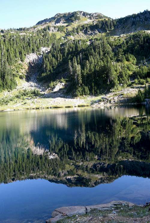
 5040 Peak from Cobalt Lake: May
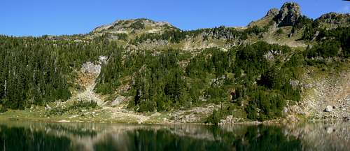 5040 Peak & The Cobalt Lake Basin: September
Groups such as the Alberni Valley Outdoor Club (AVOC) have marked routes and even built trails on several local mountains and 5040 may just be the best example of such selfless enthusiasm. Two excellent routes lead to the summit and they may be combined into a loop with a little vehicle shuttling.
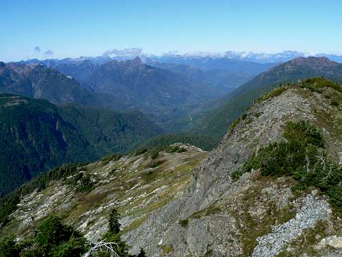
However, the single most compelling reason to visit 5040 is the view. I thought I’d seen the best the Island had to offer from such superb vantage points as The Golden Hinde, The Comox Glacier and even Merry Widow Mountain in the far north of the Island. Yet the views from 5040 left me wide-eyed and lost for words. I would never have believed that so much beauty was possible within one 360° arc. For the very modest effort required to reach the summit, 5040 delivers the goods and in spades.
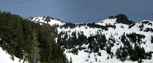
This area of Vancouver Island is less than 30 km as the crow flies from the open Pacific Ocean. Winter snowfalls are, therefore, frequent and copious. No surprise, then, that 5040 is one of the most popular ski peaks on the Island, particularly in Spring.
Getting there/Approach
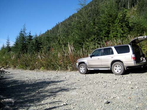
Vancouver Island can be reached directly by air from Toronto, Vancouver, Seattle, Calgary, Edmonton and recently from San Francisco to either Victoria, Nanaimo, Comox or Campbell River and by ferry from Port Angeles to Victoria on The Coho and on BC Ferries from Vancouver to Victoria or Nanaimo. Public transport on the Island is notoriously poor and anyone arriving by air would be advised to rent a car.Access in this case involves steep, rough, de-commissioned logging roads with some deep water bars. A normal 2WD vehicle might be able to reach the NW ridge trailhead (see below) but a 4WD vehicle with high clearance is essential in order to reach the point that give access to the Cobalt Lake route trailhead. Chains will also be required if the roads are still under snow. This can occur well into May.
 NW Ridge Route Trailhead NW Ridge Route Trailhead |
 Cobalt Lake Trailhead Cobalt Lake Trailhead |
Drive up Marion for 6 km to a flat wide area between two bridges. The first bridge has a solar powered water monitoring system built next to it. Access to the northwest ridge route starts here at N49 12.245 W125 19.102 and about 400 metres elevation. A debuilt branch of Marion angles off uphill and to the left just after the first bridge, although this may be difficult to spot in summer foliage, and a bushy road goes downhill to the right. At the time of writing, however, there is plenty of flagging where the route enters the trees. As mentioned above, a 2WD drive vehicle might just make it to this spot. Thereafter lock in 4WD.
Proceed another 3.6 km up the increasingly rough road, over the divide between the Marion and Effingham drainages and down the latter to the trailhead for the Cobalt Lake route at N49 10.935 W125 18.142 and 625 metres elevation. There is room to park 2 or 3 vehicles at the trailhead and room for several more just a couple of hundred metres back up the road.
Routes
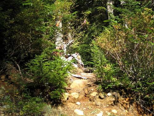
Northwest RidgeFrom the flat area between the two bridges noted above, locate the flagged trailhead where the old growth comes right down to Marion Road. As you enter the trees there’s quite a bit of deadfall and the first few minutes involve some climbing up, down, over and through it. This phase is soon over, however, and, for the most part the path is well booted-in, flagged and easy to follow.
 5040 Peak NW Ridge Route 5040 Peak NW Ridge Route |
Cobalt Lake Route
In my opinion this is much the better and more interesting of the two choices in that you start 200 metres higher and are into open terrain with superb views just 45 minutes from the car.
Locate the flagged trailhead as described above and head NE into old logging slash. This is usually a harbinger of a pain and suffering on the Island – but not in this case. AVOC have made an excellent trail through the slash as well as through the old growth above it. There’s about 100 metres of vertical gain up the slash and a further (steep) 200 through the trees before the route begins to break out into the open after skirting a rock bluff by traversing north and meeting the creek that flows out of Cobalt Lake above.
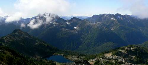
Thereafter follow flags, cairns and the, by now, slightly less evident boot-path east, southeast and finally north up to the lake and the lovely alpine basin below 5040. This is a great place for a break with already wonderful views south and west across the Effingham River valley to Triple and Cats Ears Peaks.
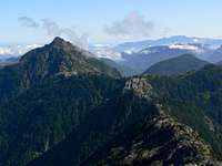
 Cats Ears from Cobalt Lake: May
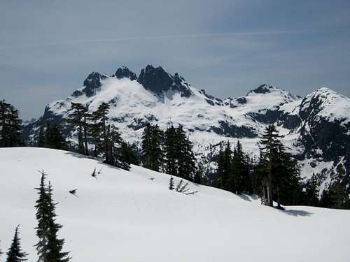 Triple from Cobalt Lake: May
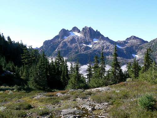 Triple from Cobalt Lake: September
Proceed on continuing excellent trail north along the west shore of Cobalt Lake (or across it in early season), directly up the forested slope facing you and onto the open ridge above. Turn right (NE) and walk up to the rocky bowl below and to the south of the summit block at about N49 11.399 W125 17.008 and about 1,400 metres elevation. There are two ways to proceed from here.
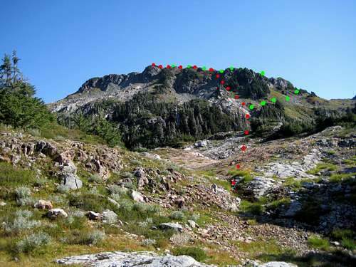 5040 summit routes from Cobalt Lake
- Head right (east) and into the col between 5040 and a lower satellite to the south. Then turn left (NW) and up the ridge to the top. Or
- Go straight ahead up steep slopes direct to the summit ridge. This is grass/heather at first, then rock/scree with some exposure.
I recommend climbing the direct option and returning via the col.
Once on the summit (and assuming the weather is fine) sit back and enjoy what is surely one of the finest vistas the Island has to offer.
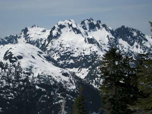
 Nahmint & Arrowsmith Nahmint & Arrowsmith |
 Hidden Peak Hidden Peak |
 Steamboat Peak Steamboat Peak |
 Pogo & Strathcona Pogo & Strathcona |
The attached summit panorama identifies what is close to hand and easily recognised. What the camera (at least my camera) fails to document are the Olympic Mountains of Washington State – 160-170 kms to the southeast – and The Golden Hinde 60 kms to the northwest. You can wile away hours on the summit of 5040 drinking it all in.
The summit of 5040 has a hydrographic survey tripod but no survey monument. There is also an Alpine Club of Canada summit register to read and sign. 5040 receives quite a few visitors by Island standards – about 20-25 parties/year – but it’s still not what you’d call a busy peak.
Descend by reversing your uptrack – or, if you can arrange a car shuttle, climb by one route and descend the other. It’s 3.6 km on Marion Main if you choose to close the loop by walking the road.
Timing guidelines – on dirt
NW Ridge Route. TH to the alpine ~ 2 hours; alpine to the summit ~ 1 hour. Descent ~ 2-2.5 hours
Cobalt Lake Route. TH to Cobalt Lake ~ 1.25-1.5 hours; Cobalt Lake to summit ~ 1 hour. Descent ~ 2 hours.
Although these times are short they don’t include the many stops you’ll want to make to take photographs and generally soak in this wonderful area. I’d allow at least 6-7 hours overall.
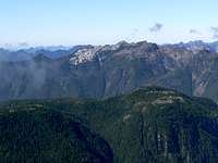
 Triple & Cats Ears from 5040
As always, Garmin/MapSource tracklogs for the approach and both climbing routes are available for the asking.
Red Tape and Safety Considerations
No red tape.Be aware that there’s no such thing as an intentions system in this neck of the woods. Make sure, therefore, that you have left a detailed trip plan with someone responsible. The RCMP and the appropriate SAR agency will respond in an emergency but it is up to you to have the mechanism in place that will initiate the call-out process if it becomes necessary.
I had full cellular service (Rogers) from the summit of 5040 but didn’t check it anywhere else on the mountain.
Camping
Most will day trip 5040 – although I might be seriously tempted – as many are – to lug a tent up to Cobalt Lake just for the pleasure for spending a night in this wonderful place. If you do, be aware that fires are strictly prohibited, so you must pack a stove. Bear and cougar frequent the mountains and forests of Vancouver Island, so proper back country methods – hanging food bags out of reach, cleaning up all cooking scraps, good toilet practice etc – are essential. Giardia is well documented throughout the Island, so boil or treat all water.If you need to car camp for an early start there’s plenty of room at the NW Ridge trailhead. Marion Creek is right there for water but it might be a hairy scramble down to the creek bed, so haul a barrel in with you.
There’s less room (and no water) at the Cobalt Lake trailhead – but more in the higher flat spot a couple of hundred metres before the TH as described in the approach directions above.
Weather
To the westTo the east
Additional Information
The correct map for this trip is the government 1:50 000 topographical map sheet 92 F/3, “Effingham River”. Advance copies can be ordered on-line at this link. Copies are usually readily available in good bookstores and outdoor stores throughout the Island.Suggested Reading
Island Alpine – A Guide to The Mountains of Strathcona Park and Vancouver Island, Philip Stone, Wild Isle Publications, 2003, ISBN 0-9680766-5-3 and/or visit Island Alpine Climbing Guide
For general backroad information and directions get hold of a copy of Backroad Mapbook. Volume III: Vancouver Island
Summit Panorama
  |