
|
|
Mountain/Rock |
|---|---|
|
|
40.76397°N / 110.5159°W |
|
|
Duchesne and Summit |
|
|
Hiking |
|
|
Summer, Fall |
|
|
12531 ft / 3819 m |
|
|
 Oweep Peak is on the right
Overview
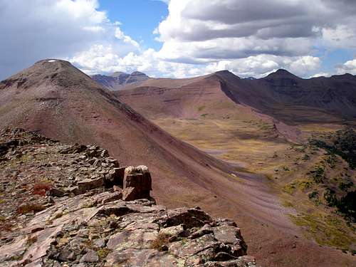
Oweep Peak lies on the main east/west ridge crest of the Uinta Mountains of Utah. At 12531' high and a prominence of 471' it ranks 61 of 118 on Scott's list of Utah 12000 footers with over 200 feet of prominence. It has no official name, only that which Scott dubbed it because it rises above the barren Oweep basin to its east.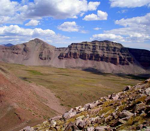 Looking east-southeast across Oweep Basin to Porcupine and South Porcupine Mountains Looking east-southeast across Oweep Basin to Porcupine and South Porcupine Mountains |  Looking south-southeast across Oweep Basin to Stone Benchmark Looking south-southeast across Oweep Basin to Stone Benchmark |
While other peaks in the vicinity are a solid red, Oweep Peak appears to be more of a silvery red and almost shimmers.
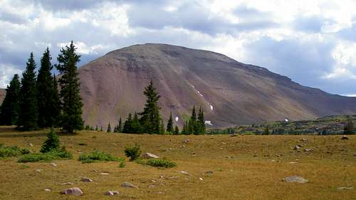 Oweep Peak viewed from the north
From just east of the summit is probably the best view of the very red Squaw Benchmark (12990') to the northeast. Kings Peak (13528'), Utah's highpoint, can also be seen 7.5 miles to the east. The most prominent 13000 footer is the 13060' Mount Wilson, visible in both pictures below.
 Squaw Benchmark viewed from Oweep Peak Squaw Benchmark viewed from Oweep Peak | 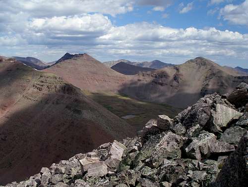 View towards Kings Peak View towards Kings Peak |
The summit of Oweep Peak is long and flat. Its west ridge is fairly gentle with a series of steps. The following pictures show the approach from the west.
 |  |  |  |
Its east and northeast ridges are steep boulder hops with the northeast ridge appearing the easiest. Its north face is even steeper. Both of these ridges as well as the north face are shown in the picture below.
 Oweep Peak viewed from the northeast
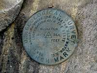 Benchmark ET-57 on Oweep Peak Benchmark ET-57 on Oweep PeakOweep Peak has the distinction of having a USGS benchmark, designation ET-57 located on its summit at N40 45.838 W110 30.954. This peak is seldom climbed. It is 8.4 miles as the crow flies to the East Fork Blacks Fork Trailhead to the north and 13.8 miles to the Lake Fork Trailhead to the south. However, it is only about a 1.5 mile (one way) side trip from the Highline Trail, the premier hiking trail of the Uintas, which crisscrosses the main crest and stretches from the Mirror Lake Highway on the west to Highway 191 on the east. It is even closer to the Little East Fork Blacks Fork Trail, being only .5 miles away. |
Getting There
Take I80 to exit 34 in Wyoming and head to Fort Bridger. Go 5.3 miles to a blinking red light. Turn right on Wyoming state route 414 and go 3 miles to Wyoming state route 410. Follow 410 for 13 miles. First you will see a sign that says the pavement ends in 750 feet. Shortly you will see another sign for "Blacks Fork River Access Area" and then another one that says "Wasatch Nat'l Forest/Meeks Cabin 13". If you miss the signs, don't worry, the three sets of rumble strips should wake you up. Do as the signs say and turn left. The road you turn onto starts out paved but soon changes to dirt. Follow the main road 23.6 miles to the signboard (just past a gate) for the East Fork Blacks Fork Trail. The trail start is just before the signboard. There is no parking right at the trail start. Instead, continue on the road for just a few feet and turn right and then left into the parking lot.On the Wyoming side, the dirt road is beautifully graded and maintained and you can make good time. Once it crosses the Utah border it gets noticeably worse and once it passes the intersection with the dirt road headed for the Mirror Lake Highway, it gets worse still. It's somewhat rocky but is fine for passenger cars if you go slow.
Red Tape
 The trailhead
Normal wilderness area restrictions apply. Check the signboard at the trailhead for the most uptodate information.
Camping
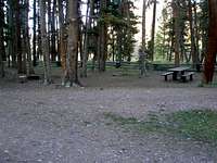 The campground
There is a free campground at the East Fork Blacks Fork Trailhead. There are 7 official sites all of which have fire pits. Four of these have picnic tables and three do not. Even on weekends, I've seen at most three sites in use. There is no water so you need to bring your own.
If you choose to backpack, you should have no problem finding a spot along either the Little East Fork Blacks Fork Trail.
When to Climb
 Oweep Peak viewed from the northeast
If you want to avoid snow, mid July through the beginning of September are the best months. Creek crossings will be significantly easier later in the summer. The dirt road leading to the East Fork Blacks Fork Trailhead is not plowed in the winter.
Routes Overview
Blacks Fork Ridge LoopThe most straightforward way to climb this peak would be to head for Squaw Pass on the Little East Fork Blacks Fork Trail and shortly before the pass, ascend the northeast ridge. However, there are a slew of other 12000 footers in the region, and a nice loop hike can be made that climbs Oweep Peak plus 5 other 12000 footers in one day. Start on the East Fork Blacks Fork Trail and head for the north ridge of Northwest Blacks Fork Peak. Head south on the ridge and hit Northwest, North, Central, and South Blacks Fork Peaks to the main east/west crest of the Uintas which is reached on South Blacks Fork Peak. From South Blacks Fork Peak head southeast down the main ridge and follow this ridge over West Oweep Peak (12507') and Oweep Peak (12531'). Descend to the Little East Fork Trail and follow it back to the East Fork Trail which is followed back to the start. The route is 21.3 miles long with a total of 6100 feet of elevation gain. It is primarily class 1 and class 2 with some short minor class 3 sections.
All six peaks of the route are shown in the picture below.
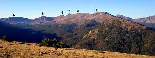 Peak 6 is Oweep Peak
Highline Trail or Little East Fork Blacks Fork

There is a 1 mile side trail leaving the Highline Trail in Oweep Basin that goes north to Squaw Pass. Squaw Pass can also be reached from the north on the Little East Fork Blacks Fork Trail. From Squaw Pass it is a .5 mile steep boulder hop to the top with a vertical gain of 730'. The total vertical gain from the Highline Trail is about 1300'. On the map at the left, the blue line show the off-trail route from Squaw Pass and the red line shows the trail from the Highline Trail to Squaw Pass.
Mountain Weather
 Oweep Peak is on the left with the snow patch
A typical summer day in the Uintas dawns without a cloud in the sky. By mid morning faint wisps of clouds are seen on the horizon. By midday the sky is half full of big puffy clouds. In the afternoon the sky is mostly overcast and possibly raining, but by early evening blue sky makes a comeback. Afternoon thunderstorms are frequent.
Here is a link to the current 7 day forecast for Oweep Peak.