
|
|
Mountain/Rock |
|---|---|
|
|
39.75560°N / 119.4612°W |
|
|
Washoe |
|
|
Spring, Fall, Winter |
|
|
8367 ft / 2550 m |
|
|
Overview
Virginia Peak is the highpoint of the Pah Rah Range, a mountain range that stretches north from Sparks, Nevada to Pyramid Lake. It is located about 25 miles northeast of downtown Reno. It isn't the most popular mountain in the area, but sees a lot of traffic because a road goes all the way up to the summit, making it a relatively easy outing.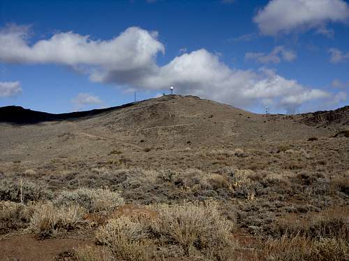
Looking towards the summit.
As the highpoint of the Pah Rah Range, views from the summit are expansive. However slightly lower peaks to the north block the view of virtually all of Pyramid Lake. Fortunately, Pah Rah Mountain 8,247 feet, is 2 ¾ miles north up the summit ridge and offers tremendous views of Pyramid Lake.
Virginia Peak can be hiked all year round. However, the best time to hike is in between March and April and October through December. It is miserable to hike in the summer heat unless it is in the morning.
It is best approached from the west side, although east side routes are possible. The west side is closest to the Reno/Sparks area, and is the side with the summit road.
Getting There
From Reno take I-80 east to exit 18 (Pyramid Highway – Highway 445). Follow Pyramid Highway north through Spanish Springs, and continue as the road becomes two-lanes. It is 18 miles from I-80 to the turn off onto Ironwood Road. The turn off is just before the Wild Horse Corral. At the turnoff, follow Ironwood Road, which is a well-graded dirt road, for 4.8 miles to a T junction with Amy Road. Take a right on Amy Road and follow it for about 0.4 miles where the road curves to the left and turns into Wilcox Ranch Road. Follow Wilcox Ranch Road for 2.3 miles and take a left on Quaking Aspen Road. Follow Quaking Aspen Road for 3.3 miles. The road is well-graded dirt, but gets narrow at points. 2WD can easily make it up the road. At 3.3 miles, the road forks left to Microwave Road. 2WD can make it up the road further, although I found a spot about 700 yards up to park on the side of the road. You can continue up the road further, if you want to shave distance, even up to the base of Virginia Peak (so you can explore other mountains). The road is only difficult when muddy. Rocky parts on spots of the road may give one pause to use low-clearance 2WD.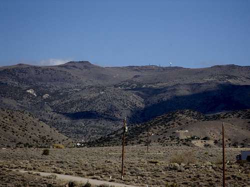
Virginia Peak from the valley below
Primary Route
These directions are from the start of Microwave Road whether you drive it or hike it. Take the road for almost two miles until the road cuts to the right and follows below a ridge (see photo below). Hikers can bushwhack up the ridge for fun and/or save some distance, which is steep, but not too difficult. The elevation gain to the top of the ridge is about 675 feet. Try to follow the brown boulder fields up the slope. At the top of the ridge, the Virginia Peak summit comes into view.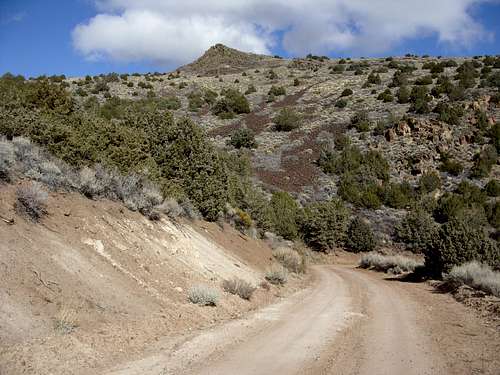
The base of the ridge
From the ridge, descend about 175 feet down to the road below. There are several options from here to reach the summit. The road heads up to the summit, but there are also options along the road to cut up the slope straight towards the summit. It is about 750 feet up to the summit from here.
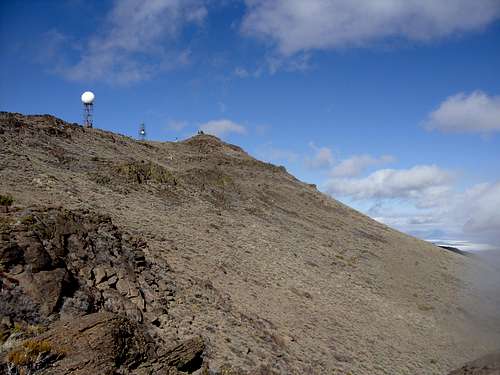
Approaching the final summit
If hiking from the start of Microwave Road, it is about 4 3/4 miles to the summit with 2900 feet of total elevation gain. If the road is taken instead of the ridge, it is a little over 5 ½ miles to the summit. 2WD can, in dry conditions, make it to about 1 mile and 750' from the summit without too much trouble.
If you follow the summit ridge for about 2 ¾ miles to Pah Rah Mountain 8,247' to view Pyramid Lake. For this hike, it is recommended you start at the base of Virginia Peak.
Red Tape
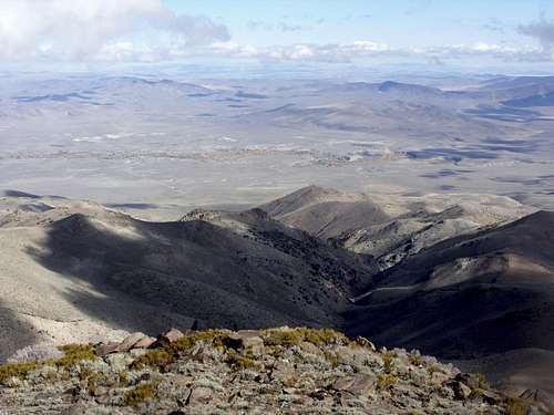
View east to the desert from the summit. The green area is where the Truckee River runs through to Pyramid Lake.
Virginia Peak is mostly on lands managed by the Bureau of Land Management. The summit has a Doppler Radar Station, but the summit is still open to the public. As long as Microwave Road is followed, there are no access issues. Quaking Aspen Road also goes up to Virginia Peak from the south, but private land between the road and the peak has a "No Trespassing" sign.
Bob Burd - Apr 22, 2012 10:37 pm - Hasn't voted
ironwood rd"follow Ironwood Road, which is a partially paved road that is covered in dirt" Actually there's no pavement once you start on Ironwood Rd. The major dirt roads in the valley are treated with an oil-based coating once or twice a year to keep dust down. The directions to the summit are excellent btw. I would only add that Microwave Rd is periodically graded and often any vehicle can drive up there. I managed it in a low-clearance van all three miles to the top.
hgrapid - Apr 23, 2012 11:17 am - Hasn't voted
Thanks BobI made the change. I have been there twice actually. What you said makes sense.
jvyduna - Apr 29, 2013 12:45 pm - Hasn't voted
Thanks + distancesFirst, thanks for the excellent description. It was easy to follow, and made my weekend to be able to explore such an empty area. I did this late April, 2013. I'd like to add that the bushwhack over the ridge had a lot of ticks, so take usual bushwhacking precautions. Also, they may have redone the roads; I wanted to report slightly different distances. Car odometer, GPS, and Google Maps all somewhat agree that If you park 700 yards up Microwave road as suggested, total on-road distance is 5.7 mi to summit. Starting up higher from the base of ridge (again staying on the road) the distance to the doppler on summit is 3.2 mi. Hope this helps others. Thanks for your helpful post!
cellohiker - Apr 23, 2015 5:18 pm - Voted 9/10
UpdateI did this hike last weekend (4/19) solo and thought I would add a few things I thought/noticed for those that are thinking of doing this one. Once you pull off of pyramid highway the dirt roads are marked pretty well so as long as you have a high resolution map with you (I just used my phone), you should be set. To make it more clear: the entire hike is up microwave road. Wherever you decide to park, you then have to hike the remaining distance up the road. I pulled off by a fork in the road that led to the scattered residences in a small valley (kind of by a larger ranch). You can definitely drive up it the whole way in a vehicle. I'm pretty sure my 2 wheel Xterra could make it up )but where is the fun or exercise in that?). Also the wear and tear on your car would be not-so-great. From where I parked it was about 11 miles round trip (5.5 each way). In my opinion it is a good candidate for a solo hike since you get extremely good cellular reception the entire time. Also it's similar to Peavine (for those of you in Reno) in the sense that you are essentially just walking up a steep dirt road the whole time. In reference to the "bushwhacking" segment I'm not sure where one would even do that. I kept my eyes peeled the whole time and didn't see anything worth leaving the road for in terms of a short cut. It's even more straightforward than they made it seem in the description. Also one should note that if you want more of a "rustic" vibe to your hike this wouldn't be a great candidate. You can tell it's heavily trafficked by vehicles (one even drove past me on the way up). But if you don't mind that it's a wonderful time. Once you get to the almost-top you have two options of peaks to go to (visible weather stations on each one). I would advise going up both (time-permitting) since they both give spectacular and unique views. The second one (with the giant ball) has an unlocked port-a-potty in case you made any bad pre-hiking meal decisions. Overall I would highly recommend this to someone looking for a nice day hike, definitely a good workout. Also keep your eyes peeled for wild horses around the trail!
hgrapid - Apr 23, 2015 6:46 pm - Hasn't voted
Re: UpdateExcellent comments. I made some changes. Thanks!