
-
 4407 Hits
-
 83.69% Score
-
 17 Votes
|
|
Mountain/Rock |
|---|---|
|
|
44.75520°N / 107.6771°W |
|
|
Sheridan |
|
|
Hiking |
|
|
Spring, Summer, Fall |
|
|
9634 ft / 2936 m |
|
|
Overview
 Fishook Creek drainage
Peak 9634 is an unassuming mountain located in the northern Big Horns of Wyoming. The mountain is right off of the highway, but the summit is not visible from the road due to the thick forests which blanket the mountain's southern slopes. The easiest route to the summit involves a beautiful hike along Fishook Creek before skirting the forest to the top, which is graced by one of the large rock cairns that is typically found on peaks in this area.
This is a very pretty area in the late spring and early summer, when there is still some snow in the shaded areas and the bright hues of the many varieties of wildflowers mix with green grass to produce a spectacular palette of vibrant color. The summit views include Hunt Mountain, Tongue River Peak and distant views of Cloud Peak and the other major peaks of the Big Horns. As with many mountains in this area (and in Wyoming), this mountain has no official name. For the purposes of this page, I am calling it "Fishook Peak" after the creek that runs along its base.
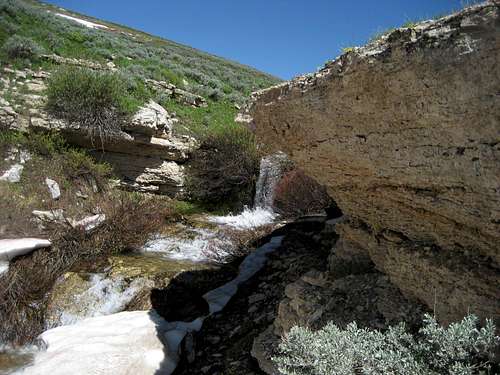 Small waterfall on Fishook Creek
Getting There and Climbing Information
 Tongue River Peak
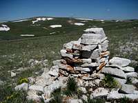 Summit cairn
From Lovell, Wyoming, take U.S. Highway 14A heading east for about 33.0 miles; to approach from Sheridan, Wyoming, follow Highway 14 to Burgess Junction, turn right on Highway 14A, and travel for 11.0 miles. Just west of the spot where Wheddon Spring is marked on the map, there is a small road marked that loops over the creek north of the highway. In reality, this road does not loop; it looks like there was a bridge there once, but it is long gone, so once you park off of the highway, keep to the left side of the creek.
While it would be possible to head straight up through the forest, this would be a thick, and most likely unpleasant, bushwhack in the trees. An easier route is to follow game trails along the left (west) side of the creek for about a mile to a point where the creek narrows enough that is possible to jump across it. There is a trail marked on the map, but I did not find anything that was different from the game trails that wander along the hillsides west of the creek. After crossing the creek, head east towards the small grove of trees that stands apart from the larger forested area. The summit is at the top of a long gentle hill behind these trees; from here it looks for all the world like a spot a mile north up the ridge is higher, but it is marked as 8 feet lower on the topo map.
A round trip via this route to the top of Fishook Mountain is a little over 3.0 miles with 1000 feet of elevation gain.

Red Tape and Camping
There are no restrictions or fees for hiking in this area; keep in mind that the Medicine Wheel Passage is closed from October through mid-May. This area has an abundance of wildlife, so be especially aware of moose, elk, black bears, and mountain lions when hiking in this area. There are no grizzlies in the Big Horns.Places to camp in the Big Horns are numerous, with the majority of the range being open to dispersed camping. Camping is not allowed within 100 feet of lakes or streams, or within 1/4 mile of major roads. For complete rules and regulations, visit: http://www.fs.fed.us/r2/bighorn/recreation/camping/
 Lupine in the Big Horns