|
|
Mountain/Rock |
|---|---|
|
|
40.47418°N / 112.06694°W |
|
|
Salt Lake. |
|
|
Hiking, Trad Climbing, Sport Climbing, Toprope, Scrambling |
|
|
Spring, Summer, Fall, Winter |
|
|
6117 ft / 1864 m |
|
|
Overview.
Featured is Step Mountain, a small but very fun summit located in the western Traverse Range, above Herriman Utah. This is one of those classic small summits that can be climbed a variety of ways, all in under an hours time on some routes. This peak is perfect for those wanting a quick bout of adventure and a little exercise to boot.What makes this mountain so interesting is its contrast to the rounded alluvial peaks surrounding it on it's southern side. The geology, discussed in the Geology portion of the page gives the mountain its name. Unique views of the southern Oquirrh Range, the Bingham Canyon Mine area, and north and east into the Salt Lake Valley and the Central Wasatch beyond are provided.
Note:
Step Mountain is on private land, owned by Skaggs Catholic Center.
Click below for ownership map:

Make sure to get permission before crossing private land.
Getting There.
This peak is accessed from Herriman, Utah.From Main Street in Herriman (13100 S) turn south on Rose Canyon Drive (6400 W) Drive .8 miles from the turnoff to a stop sign where Rose Canyon Drive actually continues south west out of the intersection. Turn right, and continue on Rose Canyon Drive as it curves through the area for two miles to Step Mountain Road, which will be marked by a street sign on your left (east). Follow Step Mountain Road (dirt and gravel) east, where is curves several hundred yards and climbs south east up the mountain for another several hundred yards to a gate. During winter months the road is cleared of snow to the last home on the west side of the road, about 200 yards down the hill from the gate. Park off the side of the road to leave room for other vehicles to pass. This is where the main route access to Step Mountain begins.
Red Tape.
The biggest issue here is that much of the Hi Country Estates is private property. A sign after just getting onto Step Mountain Road states no trespassing. However the area above the homes and property is open. While checking out the mountain I stopped and talked to the property owner at the last house on Step Mountain Road and she stated that it was fine to park where the road was no longer plowed, which happens to be in front of her home. During snow free months it will be possible to park further up at the gate. Keep in mind that there is limited parking along side the road, make sure to keep your vehicle parked in such a way to allow others to pass on the road.Another thing to keep in mind, especially during the winter season, is the deer which roam the area. They are frequently seen on the roads and on the properties in the vicinity. Watch out for them while traveling to and from the area to avoid an accident.
Camping.
Camping in this area is extremely limited due to the fact of the sheer amount of private property which abounds. Butterfield Canyon further north would be a possible area, however the local Big and Little Cottonwood Canyons in the central Wasatch would be the best option, though it would mean a drive across the valley.Here is link from Utah.com, featuring camp sites near the Big and Little Cottonwood area. Check it out and take your pick.
Utah.com camping link.
When to climb and gear.
The great thing about this peak and the area is it's ease of access and year round use.Summer, Spring and Fall.
During these seasons the proper attire, weather pending is mainly all one will need. The summer season will get hot, plan of some sunscreen and plenty of water. Most footwear can be worn on the route up, the standard route up to the peak will not warrant anything special. However if you're out to get some scrambling in, a good sticky soled boot or shoe will definitely help. A good set of trekking poles can come in handy if venturing down the scree slopes on the mountains south chute. Down below the area can get muddy during the early/mid spring season or just after a fresh storm, plan on dealing with that aspect accordingly. There is minimal bushwacking involved, pants can help with that issue though not really needed.
Winter.
This is the best time perhaps to hit up this peak while the higher Wasatch Peaks are rampant with avalanche danger. Virtually no avalanche danger exists on this route/peak. For those wanting to stretch their legs snowshoes or skis will definitely help out on the approach road, when the snow is fresh. The road is very short from the parking area to the saddle, however it is shaded much of the time and postholing can be required during that portion. Proper winter attire will be needed though nothing too advanced.
Route information.
Standard Route:One way mileage: .4 miles.
Elevation Gain: 477 feet.
Class I and II.
Rough time needed roundtrip: 1-2 hours, sans a little exploring.
From the gate head up the road about a third of a mile to where the saddle area is located to the north. From here head north cross country through a short 20 to 30 foot bushwack section, then on up the hill to the saddle and up the short ridge to the summit.
South Ridge Chute.
Class III.
This variation is reached after walking up the road about .25 miles. Once seeing the south ridge and chute come into view, break off the road and head north into the brush for about 20 to 30 yards, then climb around talus and brush up to the base of the chute. The chute will lead you conveniently directly to the summit. There is not much exposure here, however if heading up or down this route with more than one person a helmet could come in handy as there is an abundance of loose rock.
Other route possibilities.
About 30 yards down the south ridge from the peak there are anchor bolts located on the top of the west face indicating a technical route for top roping. The cliff face at this point is roughly 70 feet high from the ridge to the scree below.
The east face of the mountain looks like more technical routes abound as well, though no anchors were noticed on that side.
Mountain weather.
Due to this mountains lower altitude the weather will correspond most directly with that in Herriman. Check the link below for the local forecast for that area below.Herriman, Utah weather link here.

Geology.
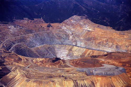
The geology of this peak is what makes it so interesting. The composition of the mountain is over turned Basalt columns, which form the "Steps" giving the mountain its namesake. Basalt is an igneous intrusive rock which forms when the mantle pushes heated rock upwards through the crust, though it never quite gets to the surface. Slowly cooling over time, the rock forms what we see today. Due to localized faulting the rock has been overturned on its side. South Mountain to the east is also formed of basalt though much less dramatically exposed than Step Mountain.The outlying boundaries to the south and west of the mountain is the prominent Oquirrh Formation, which is a layered strata of limestone, mainly gray and light tan, with thin beds of quartzite. The age of the formation dates back to 270 to 325 million years old. This formation is huge in depth, often over 20,000 feet thick is some places. The Bingham Canyon Mine, one of the largest open pit mines in the world, capitalizes on this formation for minerals like copper, gold, lead, and others.
Bingham Canyon Mine Photos: