
-
 7729 Hits
-
 90.81% Score
-
 33 Votes
|
|
Mountain/Rock |
|---|---|
|
|
44.61940°N / 107.7469°W |
|
|
Big Horn |
|
|
Hiking, Mountaineering, Trad Climbing, Scrambling |
|
|
Spring, Summer, Fall, Winter |
|
|
6856 ft / 2090 m |
|
|
Overview
 The "W"
The "W" is an intriguing and interesting peak located near the town of Shell, Wyoming. This mountain is part of the Big Horn Range, and while its elevation is low relative to the rest of the mountains around it, the rugged makeup of the peak makes it one of the most challenging peaks in the range to climb outside of the main Cloud Peak area. The peak's name is not on topographic maps, where it is marked as Peak 6856; the locally used name comes from the mountain's position between two V-shaped canyons along the west side of the Big Horns. The peak's triangular shape makes it the center of what looks like a large "W" when viewed from a distance.
The geologic forces that shaped the "W" were spectacular, judging by the amazing views during the climb and from the summit. Two waterways, Horse Creek on the north side and Dry Creek on the south, carved deep valleys around the mountain, meeting behind the peak to complete its isolation from the surrounding mountains. The 2,000-foot high anticlinal walls on either side of the peak show dozens of arced rock bands, and the west face of the "W" is made up of a slightly leaning wall of limestone. Similar formations can be found up and down the west side of the range and in other places in the nearby Absarokas as well, most notably the Palisades on Rattlesnake Mountain.
The "W" has two summits that are very close in elevation, but the eastern summit appears to be a few feet higher and is the point marked with the elevation on the map. However, the old summit registers are found in the rock cairn on the west summit (I left a new one on the east summit). According to the entries, the Greybull Buffaloes high school basketball team made several ascents to practice teamwork-building skills, the most recent of which was in 2001. According to the parental consent waiver found in the jar (slightly paraphrased), "The 'W' is not a technical climb and is generally climbed without problem or injury, but there is definitely risk and danger involved in making the climb."
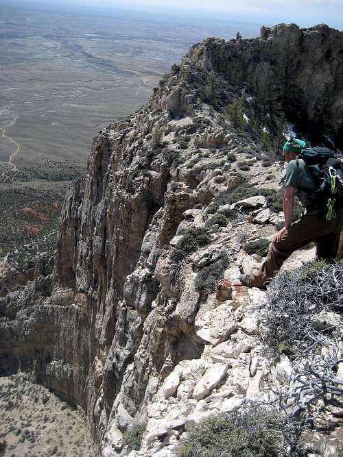 Looking over the south face from the narrow summit ridge
Getting There
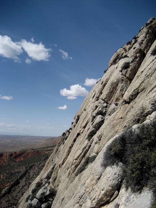
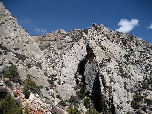
 Typical rock on the west face
 Scrambling through the scree and bushes
From the town of Shell, Wyoming, head northwest and turn left on the County Road just out of town. The road immediately crosses a bridge and bears left. Keep straight on the Horse Creek Ranch road at the fork and travel for 3.1 miles to the property boundary of the Ranch. Turn right and follow the road around the fence and towards the mountains. Keep left at the fork and drive for 0.4 miles, where you will park at the small circle where the road narrows to a 4-wheeler track.
For climbs on the west face and/or southwest ridge, hike the road for about 50 yards and keep on the single-track trail that branches right. After a half mile, you will reach an old fenced corral where Dry Creek passes into the canyon at the base of the peak. For climbs on the northwest ridge, it is faster to take a direct line bushwhacking or following the numerous game trails to the base on the Horse Creek side.
 The peak gets its name from the obvious "W" shape
Climbing Information
When I first explored the "W" in March 2010, I was hoping to find a non-technical scramble to the top and tried several different routes on the west face that turned out to be much steeper than I anticipated. After doing some tricky Class 4 stuff in a few places, I kept running into sections that were just a little too difficult to climb in my hiking boots and would have been impossible for me to down-climb. After my third futile attempt I decided to head down to Dry Creek to check out the south side, given that the walls to the north had less vegetation and appeared even steeper from that vantage point. After ascending a very steep 1200-foot scree gully to the massive cave seen in the picture below, I again reached a dead end and gave up for the day, determining to come back later with a partner and some gear.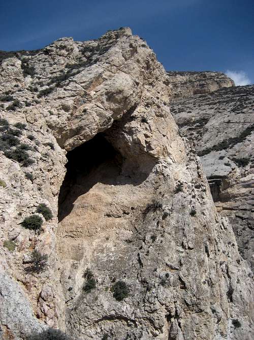
After reaching the register and reading the bit about this being a "non-technical climb," I looked again after getting off the mountain and am surmising that the northwest ridge bordering the west face is the easiest route, as the angle of the ridge is less steep and the way is not blocked by large pinnacles. I have not yet tried this route, so I cannot attest to what it is like, but I'm thinking that this must be the scrambling route, given that the west face requires rappelling for a descent and the north, east, and south sides are guarded by completely vertical cliffs. Regardless, this route will probably still be a Class 4 climb, with exposure and some tricky down-climbing.
 West face
On April 18, Doug and I climbed a route on the west face just below the southwest ridge that we decided to call a "5th Class wander;" while the route was far from being a nice, aesthetic line, it got the job done in about 3 or 4 pitches of easy climbing with a few isolated 5.5 and 5.6 moves. The rock is a little loose in places, but it is generally pretty solid, offering limited options for protection, which is not really a big deal due to the frequent large ledges and easy climbing. The biggest challenge of climbing this face is keeping the rope from becoming entangled in the bushes that are found in the most awkward places - there are several spots where the rock climbing could be avoided in favor of negotiating scree while getting up close and very personal with the bushes, if that's your thing! The main goal of any of the numerous climbing possibilities on this part of the mountain is to reach to large bush-filled gully that reaches the ridge between two rock spires; there is a small cave under the north one that is a good spot to drop the gear for the remaining scramble to the top.
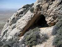 The small cave above the gully
 Approaching the west summit
From here, scramble the scree slopes or Class 3 rock to the gentler slopes just below the west summit, which has a cairn and few bottles containing summit records. To reach the higher east summit, you will have to descend a steep, 20-foot high section on the left side of the knife ridge before the reaching the top. There are some awesome drop-offs and exposure on all sides along the ridge and from the top. To descend the west face, carefully down-climb the large gully below the cave and traverse left to the next gully when it starts to get really steep. Doug and I used slings for two rappels, the first off of a rock horn and the second off of a tree. Another 50 feet of Class 4 down-climbing gets you off of the face.
 Looking west from the summit
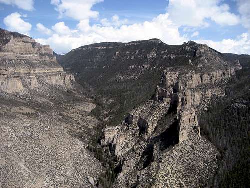 Summit view east
Red Tape and Camping
The "W" lies just outside of the Big Horn National Forest on BLM land. The Elkhorn and Dry Horse Creek Trails lead into the mountain just past the peak, where camping would be governed by Forest regulations. Places to camp in the Big Horns are numerous, with the majority of the range being open to dispersed camping. Camping is not allowed within 100 feet of lakes or streams, or within 1/4 mile of major roads. For complete rules and regulations, visit: http://www.fs.fed.us/r2/bighorn/recreation/camping/. For rules regarding camping on the BLM land, visit http://www.blm.gov/pgdata/etc/medialib/blm/wy/information/docs.Par.1775.File.dat/wynf-0019.pdf.There is a lot of wildlife in this area, so be prepared to encounter moose, black bears, rattlesnakes, and many other less dangerous animals.
External Links
The "W" (Peak 6856) on Lists of John:http://listsofjohn.com/PeakStats/Climbers.php?Id=10413