
|
|
Mountain/Rock |
|---|---|
|
|
47.27761°N / 121.15199°W |
|
|
Kittitas |
|
|
Hiking |
|
|
Spring, Summer, Fall |
|
|
4942 ft / 1506 m |
|
|
Overview
Para Point is the unofficial name for a peak located at the intersections of the Domerie Peak Trail #1308 and Domerie Divide Trail #1308.2, on the western side of Kittitas County, Washington. "Para Point" gets its nickname from Para Creek, which runs down the east side of the peak and into Cle Elum Lake. Although the summit is mostly forested, good viewpoints can be found nearby, looking south, east, and north. Para Point is a good destination for amateur hikers, and a central location for other nearby peaks such as Thomas Mountain, Mount Baldy, and Domerie Peak, each located on the same ridgeline. Looking Northeast At The Enchantments
Para Point is most easily and commonly reached from the Easton Ridge Trailhead #1212. The trail system leading to Para Point begins by switchbacking up the northwestern corner of Easton Ridge along Trail #1212, with ~1100' elevation gain in 0.8 miles. From there, the Easton Ridge Trail heads southeast along its namesake ridgeline, while the Domerie Divide Trail #1308.2 heads northeast towards Para Point. Trail #1308.2 has ~1350' gain in 1.4 miles.
 Ascending To Para Point...
From Para Point, nearby peaks are easily accessible. Thomas Mountain (5269') is only ~1.25 miles north of Para Point along the ridge, and even further are the various peaks of French Cabin Mountain. Mount Baldy (5107') is only 1.1 miles southeast of Para Point along the ridge, and Domerie Peak (4771') is only ~0.5 miles further than that peak.
 Forested Summit
Para Point can be summited year-round. However, the mountain is mainly recommended for Spring, Summer, and Autumn months. The mountain is not recommended during Winter months, as well as periods during snowpack, due to the steep terrain needed to reach the peak.
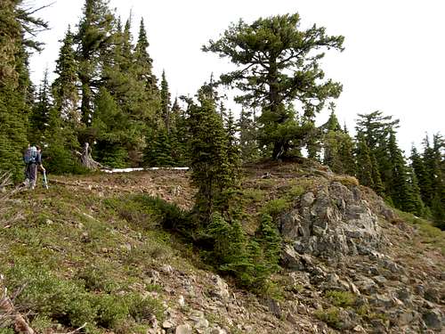
 Ascending Steep Trail #1308.2 Towards Para Point...
Getting There
From I-90, east of Snoqualmie Pass:
1) Take Exit 70 ("Easton/ Sparks Road" exit).
2) Briefly head north to a "T" intersection. Take a left turn.
3) Drive approximately one mile to Kachess Dam Road. Take a right turn.
4) Drive approximately 0.8 miles to an unmarked forest road. Take a right turn.
5) Drive approximately one mile along the unmarked forest road to the trailhead for Trails #1212 and #1315.
Red Tape
No parking pass, fee, or permit is required for parking at the trailhead.Trails #1212 and #1308.2 are for hiking use only.