
|
|
Mountain/Rock |
|---|---|
|
|
42.51581°N / 111.92349°W |
|
|
Bannock |
|
|
Hiking |
|
|
Spring, Summer, Fall |
|
|
9167 ft / 2794 m |
|
|
Mountaingazelle's pic is the signature shot in the upper right.
![The summit is that way]()
Sedgewick Peak
![Looking east]()
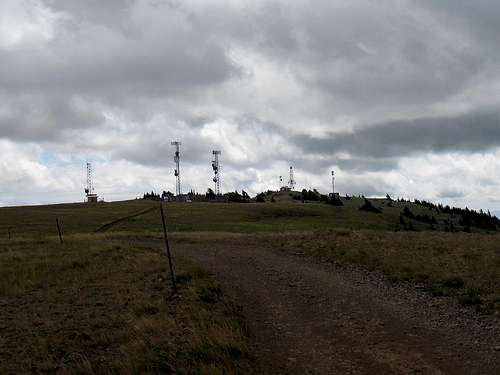
And yes, it is a drive up although not in a passenger vehicle, since really need to have a 4WD high clearance vehicle. You could hike up from the gate that is at the beginning and it is only 9.5 miles and several thousand feet of elevation gain to do the hike (one way) but since there is a road that can take you to the top, it might be a better choice for many of you. I will always point out that it isn't the fault of the mountain that mankind has put a road up to its summit but this mountain deserves the respect we can give it, road or no road. The road has some steep sections and is very rocky in places and good tires and good brakes (for the descent) are crucial. We did see three service trucks indicating that there was work going on at different antenna structures so be aware that you could meet these type of vehicles either as you go up or as you go down.
A "development" of sorts is taking place lower down on its flanks but while it is a privately owned area, a right of way allows access to the summit via the road that winds its way to the top. Located just south of the resort town of Lava Hot Springs, you will find locating the necessary key road to be
easy.
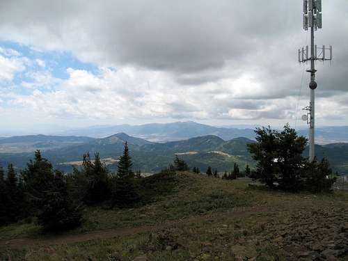
The summit is next to a communications structure and a witness benchmark and a central benchmark are to be found nearby. No register was found nor did I expect to find one at a summit that has a lot of activity going on and is accessible to vehicles/ATV's etc.
I asked mountaingazelle where the name for the peak might have come from and she gave me this educational answer:
"Several mountains in Southeast Idaho were named after Civil War generals.
Sedgwick Peak may have been named after General John Sedgwick. He was one
of the highest ranking Union casualties in the Civil War. Nearby Sherman
Peak was named after General William T. Sherman, Meade Peak was named after
General George Meade, and Bonneville Peak was named after General Benjamin
Bonneville."
SP's Mountaingazelle has put together a great page for the area, you can find it by clicking HERE.
![The gate]()
Green gate just north of the cemetary (may no longer be present)
not locked and you can open and close it and continue on your way. From the gate to the summit towers it is roughly 9.5 miles (depending on your odometer) but after the road climbs for awhile it flattens out at a development and you will find yourself on the Thunder Mountain road. Watch for the Wyoming Trail road, that is the road that will lead you to the top. Stay on this road the rest of the way, it is obvious and you shouldn't be tempted to take.
Update: A heads up from SP member runbyu mentioned that the green gate (shown above) is no longer there.
He mentioned that it is "exactly 1.25 miles from the 4th Ave W turnoff Main street to the turn and the turn comes BEFORE the cemetery."
See Ken Jones GPS track that goes all the way from the town to the summit. I have a link to it below.
![Heading up]()
The road up
![Heading up]()
Sedgewick Peak from road
For a map of Sedgwick Peak, go here.
Ken Jones put together a GPS track which may prove valuable to those
who want even more information. You can access his info at peakbagger.com
![The key intersection]()
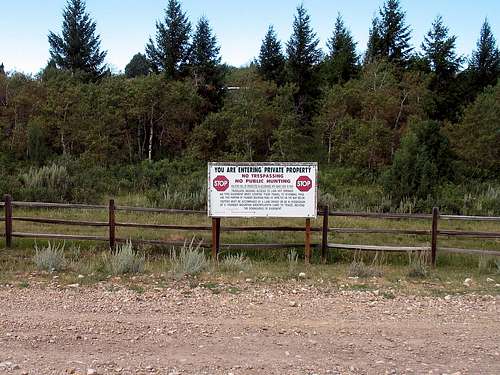
![Warnings abound]()
Caribou-Targhee NF
1405 Hollipark Dr
Idaho Falls, ID
83401
(208) 524-7500
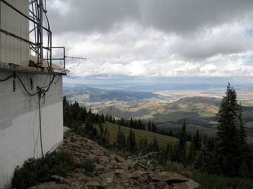
![The top]()
The summit of man
Another plan is to head over to Soda Springs and head south to 8 Mile campground, a forest service campground that has 8 or 9 spots and pit toilet facilities. Very bare bones but reasonable if you are planning on doing Sherman Peak too.
For information on Forest Service campgrounds in this region of Idaho, you could check with:
Caribou-Targhee NF
1405 Hollipark Dr
Idaho Falls, ID
83401
(208) 524-7500


Lava Hot SpringsLava Hot Springs
![Sedgwick Peak]()
Mountaingazelle's pic looking south
![The views]()
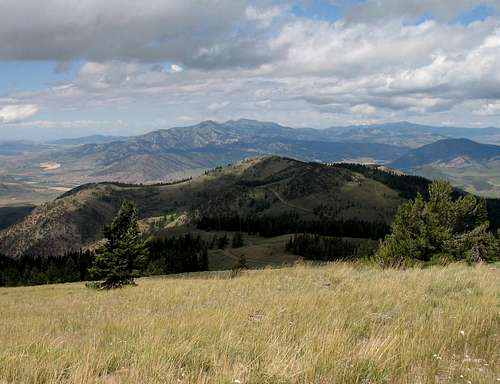
Looking east
![Baldy to the north]()
Looking north
![Looking southwest]()
Looking southwest
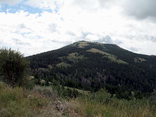
Sedgewick Peak
Overview
I recently had the chance to visit this one and was pleasantly surprised with the views that can be obtained by making the effort to visit this one. Sedgwick Peak has 3642 feet of prominence and comes in at #12 on the Idaho top 100 prominence list.And yes, it is a drive up although not in a passenger vehicle, since really need to have a 4WD high clearance vehicle. You could hike up from the gate that is at the beginning and it is only 9.5 miles and several thousand feet of elevation gain to do the hike (one way) but since there is a road that can take you to the top, it might be a better choice for many of you. I will always point out that it isn't the fault of the mountain that mankind has put a road up to its summit but this mountain deserves the respect we can give it, road or no road. The road has some steep sections and is very rocky in places and good tires and good brakes (for the descent) are crucial. We did see three service trucks indicating that there was work going on at different antenna structures so be aware that you could meet these type of vehicles either as you go up or as you go down.
A "development" of sorts is taking place lower down on its flanks but while it is a privately owned area, a right of way allows access to the summit via the road that winds its way to the top. Located just south of the resort town of Lava Hot Springs, you will find locating the necessary key road to be
easy.
The summit is next to a communications structure and a witness benchmark and a central benchmark are to be found nearby. No register was found nor did I expect to find one at a summit that has a lot of activity going on and is accessible to vehicles/ATV's etc.
I asked mountaingazelle where the name for the peak might have come from and she gave me this educational answer:
"Several mountains in Southeast Idaho were named after Civil War generals.
Sedgwick Peak may have been named after General John Sedgwick. He was one
of the highest ranking Union casualties in the Civil War. Nearby Sherman
Peak was named after General William T. Sherman, Meade Peak was named after
General George Meade, and Bonneville Peak was named after General Benjamin
Bonneville."
SP's Mountaingazelle has put together a great page for the area, you can find it by clicking HERE.
Green gate just north of the cemetary (may no longer be present)
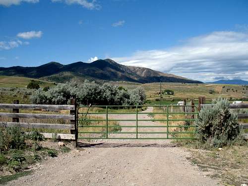
Getting There
From I-15, take the US 30 turnoff that heads east to Lava Hot Springs. In Lava Hot Springs, go into town and cross the bridge that leads to main street. Turn west on main and go to 4th Ave West and turn south. Follow this road as it works its way to the Lava Hot Springs Cemetary and the dirt road just north of the cemetary is the one you want. A green gate will bar the way but it isnot locked and you can open and close it and continue on your way. From the gate to the summit towers it is roughly 9.5 miles (depending on your odometer) but after the road climbs for awhile it flattens out at a development and you will find yourself on the Thunder Mountain road. Watch for the Wyoming Trail road, that is the road that will lead you to the top. Stay on this road the rest of the way, it is obvious and you shouldn't be tempted to take.
Update: A heads up from SP member runbyu mentioned that the green gate (shown above) is no longer there.
He mentioned that it is "exactly 1.25 miles from the 4th Ave W turnoff Main street to the turn and the turn comes BEFORE the cemetery."
See Ken Jones GPS track that goes all the way from the town to the summit. I have a link to it below.

The road up

Sedgewick Peak from road
For a map of Sedgwick Peak, go here.
Ken Jones put together a GPS track which may prove valuable to those
who want even more information. You can access his info at peakbagger.com
Red Tape
As long as you stay on the road that leads to the communication towers, you will be on the legal route and can avoid private property issues.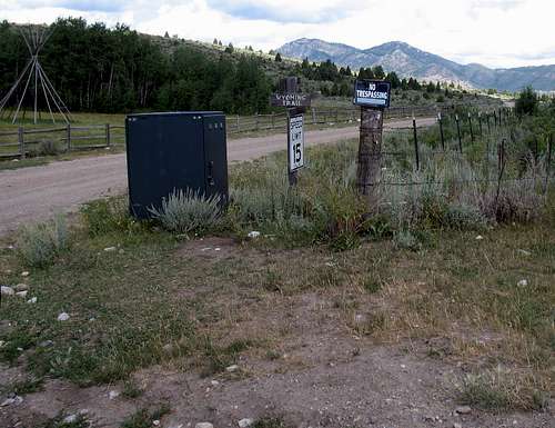
Caribou-Targhee NF
1405 Hollipark Dr
Idaho Falls, ID
83401
(208) 524-7500
The summit of man
Camping
No developed camping is available on the mountain but bush camping using the leave no trace ethics appeared possible in a couple places along the way. Avoid camping on private property. Motels and lodging can be found in Lava Hot Springs.Another plan is to head over to Soda Springs and head south to 8 Mile campground, a forest service campground that has 8 or 9 spots and pit toilet facilities. Very bare bones but reasonable if you are planning on doing Sherman Peak too.
For information on Forest Service campgrounds in this region of Idaho, you could check with:
Caribou-Targhee NF
1405 Hollipark Dr
Idaho Falls, ID
83401
(208) 524-7500
Weather
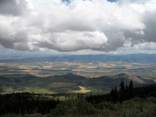
The summit and the views
While the summit itself is rather lame (surrounded by communication towers, the views can be expansive.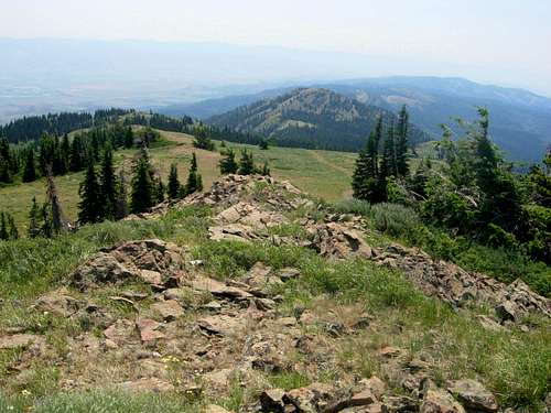
Mountaingazelle's pic looking south
Looking east
Looking north
Looking southwest
runbyu1 - Jun 30, 2015 5:27 pm - Voted 10/10
No Gate AnymoreHey there, went up over the weekend and there is no longer a gate that I could see on the road. In fact, I know you put North of the cemetery for the turn, but just for clarification you may want to add that it is exactly 1.25 miles from the 4th Ave W turnoff Main street to the turn and the turn comes BEFORE the cemetery. It is not the obvious route to take as google maps tries to take you up past the cemetery up that stretch of Thunder Mountain Road. Cheers!
Dean - Jun 30, 2015 11:21 pm - Hasn't voted
Re: No Gate AnymoreThe green gate was just a bit off of the main road. A pic of the gate: http://www.summitpost.org/the-gate/654742 If that gate is gone, then yes, it would make sense to add that news to the getting there instructions. Thanks for taking the time to share what you found. I'll add that to the directions. There was a lot of private development going on when I was there so things may have been changed. Dean