
-
 56633 Hits
-
 92.75% Score
-
 40 Votes
|
|
Area/Range |
|---|---|
|
|
46.28000°N / 12.58000°E |
|
|
9122 ft / 2780 m |
|
|
Overview
 Carnic Alps Main Ridge as seen from the ascent to Eggenkofel Carnic Alps Main Ridge as seen from the ascent to Eggenkofel |
The Carnic Alps (Alpi Carniche in Italian, Karnische Alpen in German) are a large mountain range in the Southern Alps, wedged between the Sexten / Sesto Dolomites to the west and the Julian Alps to the east. In the north you find the Gailtal Alps whereas to the south the "Prealpi Carniche" finally drop down to the plain of the Po River. Geologically the Carnic Alps are among the most important and most complex mountain ranges of the Alps (world?), since they are located directly in the region, in which the massive build-up of the Alps occurred ages ago. This results in a complex layering of the different rock composites which gave way to a number of "Geo Trails" where you can inform yourself with the help of displays placed to the sides of the trails. For more geology details, see the section below.
Besides having been the frontline in the forming of the Alps the Carnic Alps Main Ridge in the north of the range was the theatre of battle during World War I. Austro-Ungarian troops fought the Italians here in fierce battles and across the whole ridge you can see multiple proofs of the fighting 90 years ago. You'll find the actual trenches, caves dug into the rock and collapsed (sometimes still standing) forts and positions everywhere. See the Peralba Trip Report if interested in this history. Though the war resulted in a complete upheaval in the political landscape of Europe (especially in the eastern part of the Austrian empire), the actual military gains were minimal. The peace treaties of Versailles and St. Germain did more than four years of fighting. It is interesting - and sad - that the ancient peoples, actually living in the fighting zones, Furlani, Ladini, Rhaetian - had to suffer most and got shifted around in the new landscape without having a word in the proceedings.
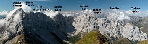 The Biegengebirge part of the Carnic Alps as seen from the Rauchkofel summit
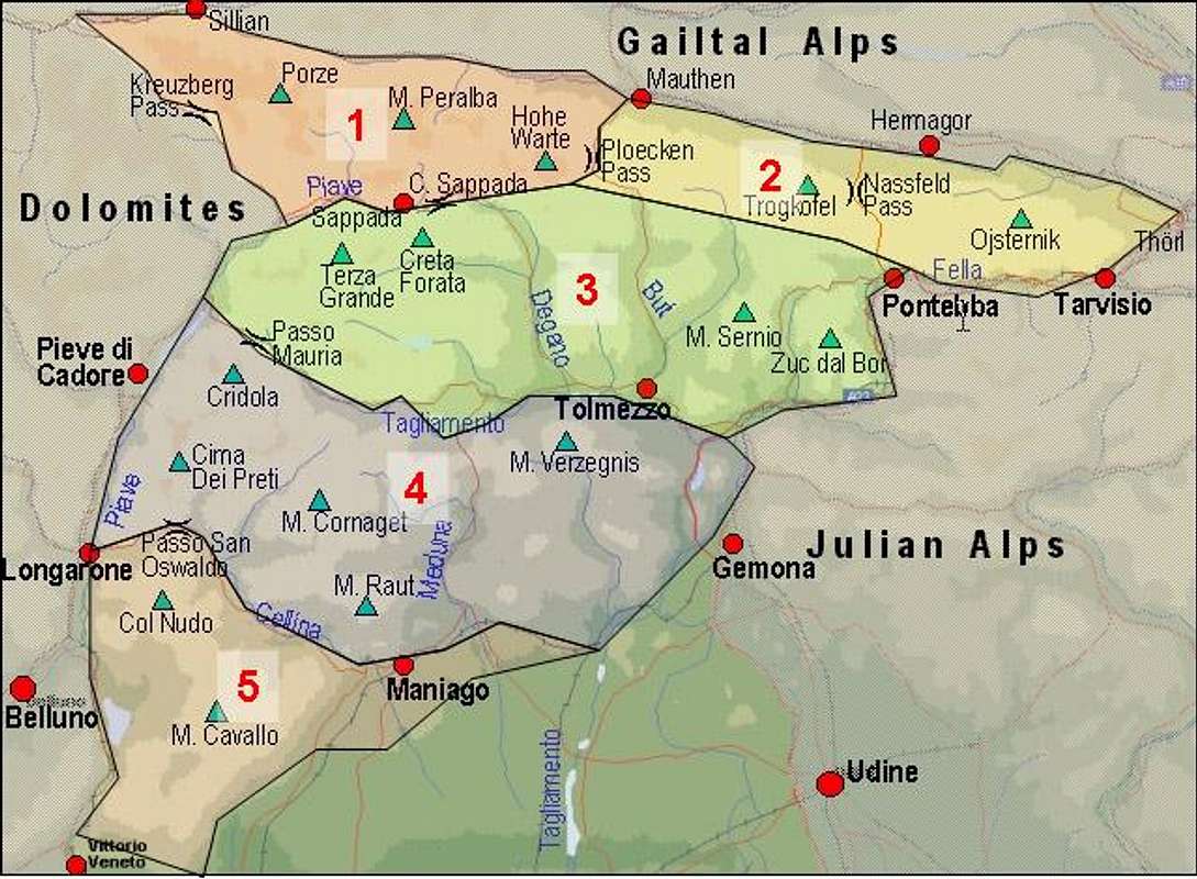
Due to the complex geology of the Carnic Alps it is not quite easy to subdivide it into special groups. The general assumption is that there are two subgroups, the Carnic Alps Main Ridge to the north of the range and the Southern Carnic Alps in the south. Both groups, however, are still very large and complex so that in a discussion thread in the Europe forum we decided on the following structure with five subgroups (bold lettering):
- Carnic Main Ridge
- 1 - Western Main Ridge (Kreuzbergpass through Plöckenpass)
- 2 - Eastern Main Ridge (Plöckenpass through Thörl)
- 1 - Western Main Ridge (Kreuzbergpass through Plöckenpass)
- 3 - Southern Carnic Alps (Upper Piave River through upper Tagliamento River)
- Prealpi Carniche
- 4 - Northern Part(Upper Tagliamento River through Cellina River)
- 5 - Southern Part (south of the Cellina River)
- 4 - Northern Part(Upper Tagliamento River through Cellina River)
Compare the Interactive Map in the "Getting There" section.
Carnic Alps Geology
As already mentioned in the overview section, the geology of the Carnic Alps is very complex. This is certainly true for the main ridge which runs from west to east along the Gail- and Lesachtal Valleys (actually one large valley which has been named differently in different sections - in the following paragraphs I will refer only to Gailtal meaning both). The valleys are part of the peradriatic fault, the geological boundary between the North African plate and the European one. The fault runs from Lago Maggiore directly through Locarno to Veltlintal, later to Adamello, before it reaches Pustertal / Val Pusteria and Gailtal. In the east it crosses the Karawanke before heading south to the sea again.In both Pustertal, the valley of the river Drau / Drava, and Gailtal the fault runs directly through the centre, the effect of which can nicely be seen by the difference of the rock composition north and east of the valley. While to the north the Zillertal Alps and Hohe Tauern are composed of solid eruptive rocks (granite, gneiss and the like) to the south most of the mountains are composed of limestone or the limestone-like Dolomite. In the area of the Carnic Alps however things get even more complicated.
What happened? First of all the area was covered by seas twice for long amounts of time. The first of these seas covered today's Carnic Alps in the Ordovicium Age. Sediments were formed and 440 million years ago a first "event" triggered the first build-up of mountains in the area. A porphyry plate was pushed over the sedimentary rocks. Remains of this plate can still be seen along the main ridge.
Erosion did away with most of the built-up mountains. Some 350 - 400 million years ago the second sea started to cover the area and overall it lasted 200 million years. This was the so-called Thetis Sea which also is responsible for the creation of the Dolomites. Huge coral atolls were formed the remainders of which are the mountain groups of the Dolomites. For instance look at the map of Langkofel / Sassolungo in the Dolomites (see below) and you will be able to see the atoll form still.
200 million years ago the final formation of the Alps began. And here the the Carnic Alps Area again was special. The mountains were kind of folded upwards, but this action took place in the form of waves which often overtook each other. With the waves "breaking" over the fault line the layering of the rocks became more and more complicated. Suddenly (think of it on a geological scale) old layers were sandwiched between younger ones, sometimes even layers of the same age several 100m apart with layers of all ages in between.
And this is what you still can find in the Carnic Alps today. The area around the highest summit, Hohe Warte (2780m) is the most complex, and thus most interesting. It is there that a so-called "Geo Trail" has been created, informing the hikers and climbers about the massive upheaval that took place 200 million years ago. These Geo Trails exist in more than one place so that - while visiting the area - you'll certainly run into one of them.
The Carnic Alps on SP
Since the mountain range is so large and complicated this section is supposed to give you the information about the summits, already posted to SP. The summits are listed west to east.- Carnic Main Ridge
- Western Main Ridge
- Helm / Monte Elmo
- Hornischegg / Monte Arnese
- Zenzerspitze
- Hollbrucker Spitze
- Demut / La Mutta
- Schöntalhöhe
- Spitzköfele
- Knieberg
- Pfannspitze
- Kleine Kinigat
- Grosse Kinigat
- Porze / Cima Palombino
- Baerenbadegg / Croda Negra
- Reiterkarspitz / Monte Cecido
- Schulterhöhe
- Zwölferspitz
- Weißsteinspitze
- Crode dei Longerin
- Peralba
- Hochalpl
- Cjadenis Group
- Mittagskofel
- Säbelspitz / Stallonkofel / Runseck
- Wolayer Kopf
- Hohe Warte
- Kellerspitzen
- Kollinspitze
- Cellon
- Rauchkofel
- Kellerspitzen
- Eastern Main Ridge
- Polinik
- Monte Zermula
- Findenigkofel / Monte Lodin
- Hochwipfel
- Trogkofel / Creta di Aip
- Monte Cavallo di Pontebba / Rosskofel
- Monte Malvueric / Malurch
- Creta di Timau / Hocheck
- Cima Avostanis / Blaustein
- Hoher Trieb / Cuestalta
- Gartnerkofel
- Garnitzenberg / Monte Carnizza
- Monte Scinauz
- Poludnig/Poludnik
- Cima Bella / Schönwipfel
- Ojstrnik
- Monte Dimon and Monte Paularo
- Kleiner Pal / Pal Piccolo
- Monte Salinchiet
- Crete dal Cronz
- Kapin / Monte Capin
- Western Main Ridge
- Southern Carnic Alps
- Prealpi Carniche
Getting There
 |
Since the border between Austria and Italy runs along the northern chain of this large mountain range the itineraries are quite different. While all the important Austrian towns and villages are lined up along the river Gail the more complex structure on the Italian side calls for different approach routes depending were you want to go.
Getting There From Italy
The most important villages / towns in the area are:
- Getting There by Plane:
The closest airports are the international airports in Venice (180 km) and Trieste (140 km)- Marco Polo International Airport (Venice)
Take the train to Calalzo di Cadore (3 hours) then by bus to all Carnic Alps villages with Dolomiti bus.
- Ronchi dei Legionari Airport (Udine)
Take the bus to all Carnic Alps villages with Dolomiti bus.
- Marco Polo International Airport (Venice)
- Getting There by Train:
Those who travel by train stop at Calalzo, the end of the line from Venice and Padova or at Carnia on the Udine Tarvisio line. Connect to any of the Italian Carnic Alps destinations by frequent bus lines that meet the main trains. So, two possibilities:- To Calalzo di Cadore (from Venice direction Belluno, three hours) then by Dolomiti bus to any of the Carnic Alps Villages
- To Udine (from Venice direction Trieste, two hours) then by Dolomiti bus to any of the Carnic Alps Villages.
- To Calalzo di Cadore (from Venice direction Belluno, three hours) then by Dolomiti bus to any of the Carnic Alps Villages
- Getting There by Car:
- From A22, Brenner motorway, exit "Ora" and then through the Pordoi and Falzarego passes to Cortina d'Ampezzo, Misurina and Auronzo (3 hours - better solution in summer period).
- From A22, Brenner motorway, exit "Bressanone/Brixen" to Bruneck / Brunico and then to the Carnic Alps over Passo Monte Croce / Kreuzbergpass or "Monte Comelico" Pass/Ploeckenpass (2 hours and half, better solution in the winter period).
- From the Veneto side take the Venice-Belluno motorway and then go towards Pieve di Cadore.
- If you come from Friuli leave the Udine-Tarvisio motorway at the Carnia exit and drive towards Villa Santina and Forni Avoltri (45 km.).
- From A22, Brenner motorway, exit "Ora" and then through the Pordoi and Falzarego passes to Cortina d'Ampezzo, Misurina and Auronzo (3 hours - better solution in summer period).
Getting There From Austria
The most important villages / towns are aligned along the Lesachtal and Gailtal Valleys. They are :
- Sillian
- Osttiroler Gailtal (click on the village links to the right
- Lesachtal
- Kötschach-Mauthen
- Hermagor
- Villach
- Getting There by Plane / Train
The nearest airports are the ones at Klagenfurt and Innsbruck, both ocal airports, which are served only sporadically.- From Innsbruck take the train to Brixen / Bressanone where you have to change to the line going through Pustertal / Val Pusteria. At Sillian change to the busline into Lesachtal towards Kötschach Mauthen.
- From Klagenfurt take the train to Villach and on to Hermargor or Kötschach-Mauthen. From there go on by bus to your final destination.
- From Innsbruck take the train to Brixen / Bressanone where you have to change to the line going through Pustertal / Val Pusteria. At Sillian change to the busline into Lesachtal towards Kötschach Mauthen.
- Getting There by Car:
- From the West (Brenner Motorway A22)
Leave the Brenner Motorway near Brixen / Bressanone and follow SS49 to the east through Pustertal / Val Pusteria. To the east of Innichen / San Candido you cross the Austro-Italian border and follow the road (now B100) to Tassenbach. Turn right (south-east) here onto B111, which runs through Osttiroler Gailtal, Lesachtal and Kärntener Gailtal. All the towns and villages mentioned above are located on this road.
- From the North
There are two possible roads:- From Kitzbühel over B108 through the Felbertauern Tunnel to Lienz, then southeast to Oberdrauburg and Kötschach-Mauthen (B110), where you turn on to B111 west into Lesachtal.
- From Salzburg along motorway A10 to Spittal. Turn west on B100 to Oberdrauburg, there south to Kötschach-Mauthen were you turn east on B111.
- From Kitzbühel over B108 through the Felbertauern Tunnel to Lienz, then southeast to Oberdrauburg and Kötschach-Mauthen (B110), where you turn on to B111 west into Lesachtal.
- From the West (Brenner Motorway A22)
Red Tape
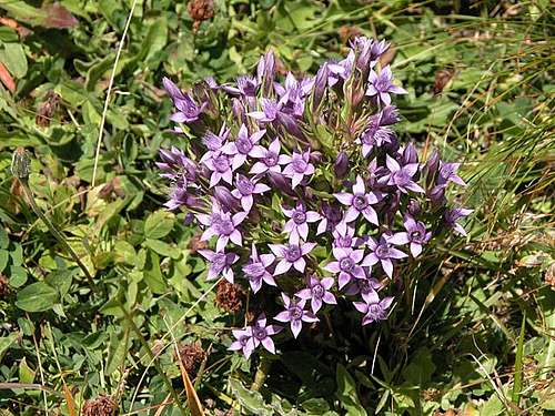 Gentian
In most of the subgroups of the Carnic Alps you won't find any red tape. An exception is the area around Wolayer See: Biegengebirge, Hohe Warte, Kellerwand. Here the usual restrictions for natural preserves apply. Don't take anything except your refuse with you. As a rule restrictions are more severe in the Austrian part of the Alps. Some of the trails are closed for mountainbiking. You will find notes and marks at the respective trailheads.
Weather Conditions
Quite naturally the weather between the northern Austrian part and the southern Italian part can be quite different. The Carnic Alps Main Ridge serves as a weather divide, especially if the winds come from the north or south. For up to date weather information follow one the links below.- Austrian side:
- Tyrol weather
- Carinthia weather
Italian side:
- Friuli/Venetia/Giulia weather
- Veneto weather
Accommodation
On both sides of the Austrian - Italian border there are a lot of hotels and appartments to be had. While on the Austrian side the relevant info can be found on one site (two links though for the different Austrian states) on the Italian side of the border you will have to look for the single towns and villages on the web. Here is an excerpt for the towns and villages mentioned in the "Getting There" section:Austria
Italy
- Sappada accommodation
- Forni Avoltri accommodation
- Pontebba accommodation
- Tarvisio accommodation
- Pieve di Cadore accommodation
- Tolmezzo accommodation
- Gemona accommodation
- Udine hotels
- Belluno hotels
Mountain Huts and Refuges
For the time being the list of huts, refuges and bivouacs won't be complete until all of the five subgroups will have been submitted..The huts of the Carnic Alps Main Ridge are connected by a well-known hiking trail which often follows the line of the batte in the first world war. Therefore the trail is named as "trail of peace" (Friedensweg - via del pace). There are several possibilities between Ploecken pass/Passo di M. Croce and Sillian or Sexten/Sesto. The route takes 5-7 days.
Here is one possible route described in english.
Refuges:
| Rifugio / Hut | Height | Open | Tel. |
| Carnic Alps Main Ridge (West) | |||
| Hahnspielhütte / Rif. Gallo Cedrone | 2200m | all year | +39 0474 710078 |
| Helmhaus | 2420m | all year | n.a. |
| Sillianer Hütte | 2447m | mid June - end Sept. | +43 4842 6770 begin_of_the_skype_highlighting +43 4842 6770 end_of_the_skype_highlighting |
| Obstanser See Hütte | 2340m | mid June - end Sept. | +43 4848 5422 |
| Filmoor Standschützenhütte | 2350m | mid June - end Sept. | +43 664 1127153 |
| Rif. Monte Cavallino | 1849m | n.a. | +39 0435 67268 |
| Neue Porzehütte | 1942m | mid June - end Sept. | +43 664 4038929 |
| Hochweißsteinhaus | 1868m | mid June - end Sept. | +43 676 7462886 |
| Rif. P. F. Calvi | 2167m | all summer | +39 0435 469232 |
| Rif. Alle Sorgenti del Piave | 1800m | all summer | +39 0435 469260 |
| Rif. Monte Ferro | 1563m | all year | +39 0368 3180179 |
| Wolayer See Hütte (ex. E. Pichl Hütte) | 1959m | mid June - end Sept. | 0043 4715 7752 |
| Rif. Lambertenghi e Romanin | 1951m | all summer | +39 0433 72051 |
| Rif. G. & O. Marinelli | 2120m | all summer | +39 0433 775143 |
| Untere Valentinalm | 1200m | all year | +43 4715 92215 |
| Plöckenhaus | 1208m | all year | n.a. |
| Carnic Alps Main Ridge (East) | |||
| Dr. E. Steinwender Hütte | 1720m | mid June - end Sept. | +43 664 1060014 |
| Straniger Alm | 1479m | n.a. | n.a. |
| Rattendorfer Alm | 1535m | n.a. | +43 664 5121538 |
| Rudrigalm | 1621m | n.a. | n.a. |
| Naßfeldhaus | 1528m | all summer | +43 4285 82710 |
| Rif. Fratelli Nordio | 1210m | n.a. | n.a. |
| Freisitzer Alm | 1718m | May - Sept | n.a. |
| Achomitzer Alm | 1700m | July - Aug. | +43 4256 3163 |
| Southern Carnic Alps | |||
| Volontari Alpiri Feltre Cadore | 1281m | n.a. | n.a. |
| De Gasperi | 1767m | summer | +39 01433 69034 |
| Monte Siera | 1606m | mid June - end Sept | +39 0435 66196 |
| Chiampizulon | 1628m | n.a. | n.a. |
| Monte Talm | 1100m | summer | +39 0433 69034 |
| Emblateribm | 1441m | n.a. | n.a. |
| Casera Losa | 1765m | n.a. | n.a. |
| Ten. Fabbro | 1783m | mid June - mid Sept. | +39 0435 460357 |
| Tita Piaz | 1417m | summer | +39 0433 86161 |
| Stella Alpina | 1331m | summer and winter | +39 0433 66009 |
| Enzo Mori | 1320m | n.a. | n.a. |
| Monte Sernio | 1419m | all year | +39 0433 41410 |
| Grauzaria | 1250m | summer | +39 0433 51361 |
| Vualt | 1168m | all year | +39 0433 51361 |
| Prealpi Carniche (South) | |||
| Rif. C. e M. Semenza | 2020m | all summer | +39 0437 49055 |
| Rif . Dolomieu al Dolada | 1494m | June - Sept | +39 0437 478086 |
| Rif Casera Ditta | 956m | all year | +39 0437 879010 |
Bivouacs:
| Bivouac | Height |
| Carnic Alps Main Ridge (West) | |
| A. Piva | 2450m |
| Mitterkar | 2000m |
| Letterspitzbiwak | 2080m |
| Eiskarhüttl | 2100m |
| E. Lomasti | 1920m |
| Southern Carnic Alps | |
| Bivacco Arsella – Zandonella | 2000m |
| Bivacco Caimi al Cornon | 2045m |
| Bivacco Marta Franco | 2045m |
| Casera Mimoias | 1623m |
| BivaccoDamiana del Gobbo | 1985m |
| Ricovero Casera Chiarzò | 1393m |
| Ricovero Casera Lavazeit | 1813m |
| Ricovero Casera Giaveada o Neveade | 1684m |
| Ricovero Casera Tintina | 1495m |
| Ricovero Casera Nauleni | 1639m |
| Ricovero Valuta | 1588m |
| Bivacco Lander | 950m |
| Ricovero Zouf di Fau | 1331m |
| Bivacco Feruglio | 1700m |
| Ricovero Monte Forcella | 1098m |
| Ricovero Pian d’Aiars | 1475m |
| Bivacco Cimenti | 1080m |
| Cjasut dal Sior | 1752m |
| Bivacco G. Bianchi | 1712m |
| Prealpi Carniche (South) | |
| Biv Scalon | 1150m |
| Ric. Casera del Pian | 1810m |
| Biv. Val Provagna | 1123m |
| Biv. Val Zea | 1245m |
| Biv. Toffolon | 1990m |
| Biv. Pastout | 1617m |
| Ric. C.ra Montelonga | 1327m |
| Ric C.ra La Pala | 1200m |
| Ric C.ra Rupeit | 1275m |
| Ric. C.ra di Giais | 1289m |
Maps 'n' Books
MapsI have been using maps by Kompass Verlag, which are very good for the hiking trails though they don't show ALL the relevant summits of the area.
- Lienzer Dolomiten / Lesachtal
1:50000
Kompass Map WK47
Kompass Verlag
ISBN: 3-85491-053-3
- Gailtaler Alpen / Karnische Alpen / Oberdrautal
1:50000
Kompass Map WK60
Kompass Verlag
ISBN: 3-85491-067-3
- Tabacco Maps, all 1:25000
001 - SAPPADA-S.STEFANO-FORNI AVOLTRI
002 - FORNI DI SOPRA-AMPEZZO-SÀURIS-ALTA TAGLIAMENTO
009 - ALPI CARNICHE / CARNIA CENTRALE
013 - PREALPI CARNICHE-VAL TAGLIAMENTO
018 - ALPI CARNICHE ORIENTALI-CANAL DEL FERRO
019 - ALPI GIULIE OCCIDENTALI-TARVISIANO
020 - PREALPI CARNICHE E GIULIE DEL GEMONESE
028 - VAL TRAMONTINA - VAL COSA - VAL D`ARZINO
Books
German Books
- Hiking and Trekking
- Osttirol Süd
W. Mair
Rother Verlag
ISBN: 3-7633-4132-3
Good descriptions with maps covering: Defregger Berge, Villgrater Berge, Carnic Alps, Lienz Dolomites
- Kärnten
G. Lehofer
Rother Verlag
ISBN: 3-7633-4187-0
Good descriptions with maps covering: Carnic Alps, Gailtal Alps, Karawanke, Julian Alps (parts)
- Gailtal – Lesachtal – Karnischer Höhenweg
Kompass Wanderbuch 982
Kompass Verlag
ISBN: 3-85491-500-4
Good Descriptions with maps and elevation profiles covering: Carnic Alps, Southern Lienz Dolomites, Gailtal Alps
- Osttirol Süd
- Ski Touring
- Kaerntner Schitourenfuehrer
Manfred Korbaj
H. Weishaupt Verlag, Graz. 1992.
- Kaerntner Schitourenfuehrer
- Climbing
- Karnischer Hauptkamm
Alpenvereinsführer
P. Holl
Rother Verlag
ISBN: 3-7633-1254-4
Excellent overall Climbing Guide through the Carnic Alps Main Ridge.
- Karnischer Hauptkamm
- ALPI CARNICHE E DOLOMITI FRIULANE
ISBN: 88-86928-37-8
Euro 16,53
see here how to to buy it
- ALPI CARNICHE, vol. I - II
A. De Rovere, M. Di Gallo;
Guida dei monti d'Italia CAI-TCI; 1988
- Tirolo Orientale Sud
W. Mair
(traduzione: Barbara Schöpf / Denise Brazzioli)
Rother Verlag
ISBN: 3-7633-4307-5
Thanks to gabriele.roth for the Italian books ;-)