
|
|
Mountain/Rock |
|---|---|
|
|
44.35280°N / 15.50760°E |
|
|
Hiking, Mountaineering |
|
|
Spring, Summer, Fall, Winter |
|
|
5610 ft / 1710 m |
|
|
Intro
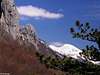
 Endless freedom on the summit of Liburnija (1710m)
There are two main reasons to climb Liburnija peak when you visit Paklenica National Park. Main reason is views, Liburnija is Panorama Queen of Paklenica! It is highest peak placed straight above Paklenica valley and faces sea directly. Views down are like from bird’s perspective. The other reason would be very beautiful and most attractive route that ascends towards highest peaks of Velebit from Paklenica area. Result is pure enjoyment and pleasure of climbing with amazing views. Also Liburnija can be combined with climbs towards highest and second highest peaks of Velebit, Vaganski vrh (1757m) & Sveto Brdo (1751m). More about that in Hike Advices section.
 |  |  |  |  |
Overview
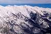
44°21'17.17"N, 15°30'45.72"E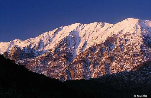 Liburnija (1710m) from Veliko Mocilo area above Mala Paklenica valley
Liburnija belongs among highest peaks of Velebit, those that exceed 1700 meters. It is placed in Vaganski Vrh – Sveto Brdo group, which contains all of Velebit 1700+ meter peaks in 10km long streak. Group rises steeply above Velika and Mala Paklenica upper valleys and has a shape of a ridge. But it is not a simple, sharp ridge. It is around 1km wide with 2 streaks of peaks, one above Paklenica, which is looking towards sea and the other, above the continental side of the mountain. Between them are huge funnel shaped basins. Both sides fall steeply. Seaboard side, above Paklenica is up to 1200 meters high and reaches it’s culmination in Liburnija.
Liburnija itself is higher head which sticks above seaboard crest and is part of seaboard streak of peaks, straight above upper Velika Paklenica valley. Above it rises some 1200m! Upper part of this side is rocky, made of cliffs or scree, while lower 2/3 are under beech, maple or black pine forest. On the back or NE side its slopes are grassy, covered with dense colonies of dwarf pine and descent into depression between seaboard and continental streak of peaks.
More about Vaganski Vrh – Sveto Brdo group find in South Velebit section on main Velebit page, Vaganski Vrh (1757m) and Sveto Brdo (1751m) pages. On Paklenica area page you can find info about central area of NP.
On October 21st 1979, at the 80th anniversary of organized mountaineering in Zadar, Paklenica mountaineering club named this peak Liburnija, opened the route from Paklenica hut and placed memorial plate on the summit. Liburnija was the first name of what today is Paklenica club. Name Liburnija comes from the name of Liburni tribe that lived in this part of Dalmatia. They were part of Illyrian people that used to live here before Croats (Slavs) came and destroyed them in 7th century.
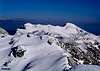
 Bura wind dance on Liburnija
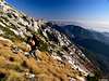
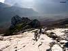
Starting point for Liburnija is Paklenica hut (480m), which is placed in the heart of the Velika Paklenica valley, on the spot where upper and lower valley meet. Route is not easy because it is long and tiring so requires good condition. Lower part is steep ascent through the forest while upper section is rock and scree climbing which is on spots quite exposed and use of hands is frequent. If you have some experience on rock all this is fun accompanied with fantastic views.
 |  |  |  |
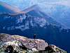
Summit View
 Sveto Brdo (1751m) from Liburnija (1710m) (SE direction)
As stated in Intro section view from Liburnija is fantastic, only little bit restricted towards north and southeast by higher peaks in continental streak. But towards sea Liburnija is ‘view champion’ of this part of Velebit. Sea view is even better than from Sveto Brdo, the undisputed panorama King of Velebit. Why when everything that can be seen from Liburnija can also be from Sveto Brdo? Reason lies in dramatic position of Liburnija, high above Paklenica valley towards which it falls steeply with scree and cliffs, while Sveto Brdo has more gentle grassy slopes in that direction, which lack such dramatics.
N: Vaganski Vrh (1757m), highest peak of Velebit, which obscures the view beyond it.
NE: between Segestin (1715m), on the left & massive cone of Malovan (1709m) on the right is Lika region with Licka Pljesivica (1657m) mountain behind it.
E: left of Malovan (1709m), in the distance, is Osjecenica (1789m) mountain in Bosnia. Just behind Malovan is Klekovaca (1961m) while right of it is Ilica (1654m), both also in Bosnia.
SE: is mostly occupied by Babin Vrh (1744m) and towering Sveto Brdo (1751m). Just right below Sveto Brdo is huge grassy Debelo Brdo (1440m). Below it is Vlaski Grad (1375m) and Vlaski Grad (1280m) pass with refuge that is visible as shiny white dot that is reflecting sun in afternoon hours. Right of Sveto Brdo and above Debelo Brdo are Svilaja (1506m) and Promina (1148m), Dalmatian mountains.
S: huge north Dalmatian plateau. Behind it is sea and islands of Sibenik archipelagos.
SW: together with W this is most beautiful part of panorama. Deep below is Velika Paklenica valley. Behind is Crni Vrh (1110m) group. Left of it is Veliko Mocilo plateau with upper Mala Paklenica valley. Right of Crni Vrh group is lower Velika Paklenica valley with canyon further towards sea. Below mountain is Velebitski Kanal (Velebit channel). Behind is flat Ravni Kotari area with Zadar city on opposite edge with sea and islands of Zadar archipelagos. On perfect day Corno Grande (2912m), highest peak of Apennines in Italy, is visible all the way across the Adriatic sea (270km away).
W: together with SW this is most beautiful part of panorama. Deep below is Velika Paklenica valley. Behind is Veliki Golic (1268m) with its huge north side. Behind is sea & islands. Right of Veliki Golic is Rujno plateau while Viserujna (1632m) is rising above it.
 |  |  |  |  |
Paklenica NP
Liburnija and whole group is placed inside Paklenica National Park, which has been established in 1949 and is second oldest Croatian National Park. Main attraction of national park is two Paklenica canyons, Velika (Big) and Mala (Small) Paklenica. Velika Paklenica is larger, as its name says; sides are higher, while Mala Paklenica is smaller but much wilder, preserved in its primeval form, without any objects or build paths. Velika Paklenica is divided in two valleys, lower and upper. Lower valley cuts through Velebit massif, perpendicularly on mountain direction, towards the sea, and ends with 400 meters deep canyon. Upper valley is bellow main ridge and is parallel with it, while perpendicular on lower valley. They form a letter T shape. Main ridge rises steeply above it, around 1200 meters, finishing with cliffs and scree slopes. Through Velika Paklenica flows Velika Paklenica creek, which making thundering noise in the canyon. Lower half can dry out during long summer droughts.Canyon of Velika Paklenica is climbing Mecca for alpinists from around Europe and wider. There are over 1000 routes of various difficulties, from training to expert. Because of position just by the sea climbing is possible year round. In Mala Paklenica climbing is forbidden to protect endangered birds that nest in cliffs above canyon.
More about park find on Paklenica page.
 |  |  |  |  |
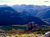
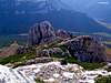
Babin Kuk (1435m)
44°21'6.33"N, 15°30'29.73"E (approximate) Babin Kuk (1435m) from Velika Paklenica valley
Babin Kuk is prominent isolated cliff that stands on the slope which rises from Paklenica valley towards highest peaks group, some 300 meters bellow Liburnija. With its smooth cliffs it offers some difficult routes to climbers. Its SW side is around 200m high while tougher SE side is around 150m. Secured path reaches it after some 15mins of climbing from Lipa Staza route towards Liburnija. View from the summit is very wide, similar to that from Liburnija towards sea while towards NE to E it is obscured by huge curtain, a wild slope that is rising above Paklenica valley of Vaganski Vrh – Sveto Brdo group. Babin Kuk is interesting 30mins long detour on the way towards Liburnija with nice climb high above Paklenica.
 |  |
Hike Advices
5 routes ascend from Paklenica hut towards highest peaks group. Lipa Staza towards Liburnija is one of them and it can be combined with climbs on Vaganski Vrh & Sveto Brdo. These combinations are only for those in good shape because all are long with considerable altitude difference but are very beautiful way to explore Paklenica area and climb highest peaks of Velebit. Both can be done in opposite directions also but it is more beautiful and easier to your knees to climb Liburnija than to descent from it. Also this is just a drop in the sea of combinations that can be done in Paklenica National Park. Those that would like to spend few more days on Velebit and walk even more I warmly suggest to combine Paklenica area (Vaganski Vrh, Sveto Brdo & Liburnija pages) with Stap and Rujno (Viserujna page) areas.1) Vaganski Vrh combination. Sleep over at Paklenica hut. In the morning climb Liburnija (4h). For those that start from Paklenica canyon add another 1.30h to Paklenica hut. From Liburnija continue towards Vaganski Vrh (1h). From Vaganski Vrh you can descent back directly to Paklenica hut (3.30h) to complete 1 day tour. If you would like to extend trip to two days continue from Vaganski Vrh towards Struge refuge where you will sleep over (2h). On the second day climb Viserujna (1632m) from Buljma pass and return back (3h tour). From Buljma descent to Paklenica hut directly (2.30h) or if you would like to extend day from junction 40mins bellow Buljma turn right and climb Veliki Golic peak (2h) and descent back to Paklenica valley via Njivarska Strana (2.30h). Routes are described on Vaganski Vrh page
2) Sveto Brdo combination. Sleep over at Paklenica hut. In the morning climb Liburnija (4h). For those that start from Paklenica canyon add another 1.30h to Paklenica hut. From Liburnija descent to VPP trail like towards Vaganski Vrh. Here you turn right, it is 3.30h to Sveto Brdo. Descent to Vlaski Grad refuge to sleep over (1.30h). To do this route in one day and return immediately to Paklenica hut is only for ‘crazy’ hikers because from Sveto brdo it takes some 4.30h to Paklenica hut. In the morning climb Vlaski Grad peak. You can return directly to Paklenica hut via Ivine Vodice (3.30h) or if you want to extend the day, from Martinovo Mirilo pass, bellow Ivine Vodice, head left towards Veliko Mocilo plateau (2h from Vlaski Grad). From here climb Crni Vrh (1h) which is very nice view point and descent to Paklenica hut (2h). Routes partly described on Sveto Brdo page.
 |  |  |
Getting There
By PlaneClosest airport is in Zadar, 45 km away. There are no international flights to Zadar (except charter flights during summer season) so you have to go over Zagreb international airport. There are everyday flights from Zagreb to Zadar except on Sunday. They are usually in the evening, around 20h. Find more info about flights on official site of Croatia Airlines
By Bus
There are numerous bus lines from Zagreb to Zadar each day, almost every half hour. The only problem is in the fact that there is no direct bus to Starigrad Paklenica from Zagreb. Some lines go via highway some use road via Gracac. Those that go via highway don’t stop on Maslenicki Most bridge location so from Zadar you have to take bus back towards Rijeka. Those that go via Gracac stop on Maslenicki Most bridge. Wait there for the bus towards Rijeka or you can hitch-hike to Starigrad Paklenica, which is 15 km from here.
Detailed bus timetables you can find at Zagreb bus station site.
By Train
Train is not a good option if you are coming from Zagreb. It travels longer than bus and you have to change the train in Knin towards Zadar and than take a bus to Starigrad Paklenica. Train timetables can be found on Croatian railways site.
By Car
The best way is to come by car. There are two main directions to come to this area, from Rijeka or Zagreb.
From Rijeka, along the coast
This route is suitable if you are coming from western Europe, via Trieste (Italy).
Trieste - Rijeka 70 km
Rijeka - Starigrad Paklenica 180 km
From Zagreb
This road is suitable if you are coming from eastern or central Europe via Ljubljana (Slovenia), Maribor (Slovenia) or Budapest (Hungary).
Ljubljana - Zagreb 138 km, Maribor - Zagreb 113 km, Budapest - Zagreb 347 km
Zagreb - Starigrad Paklenica (via Plitvice and highway) 250 km
From Zadar
Zadar – Starigrad Paklenica 45km
Look for current road conditions in Croatia on the page of Croatian Automobile Club (HAK).
 |
When To Climb
Find out more about climate on Velebit main page.Summer season lasts from June to August. All you need then is lot of water. Walking poles are good to have in lower ¾ of the route which goes through very steep forest. Last part is climbing where hands are often in use so poles will be on your back pack.
Autumn season is October. Colors in Paklenica valley are beautiful then (last third if month). Snow on Liburnija is not rare in October. This varies from year to year but every second year highest part of Velebit is covered with snow in the second half of the month.
Winter season lasts from November to May. Crampons and ice ax are very necessary. Rocky ridge which path follows on the way up is very steep with smooth cliffs at angle up to 50 degrees. Sections that are steep for snow to hold on can be icy. If you are not an experienced on this kind of terrain it is better to avoid it over scree and rocky slopes to the left or right. They are covered with compact snow.
Spring season is May. In Paklenica valley nature is fluorescent green and very beautiful while on Liburnija is still fresh. Snow usually disappears from southern slopes, where path ascends, in May but northern slopes are still under hard packed snow, so if you are continuing towards Vaganski Vrh or Sveto Brdo take crampons with you at least.
 |
Mountain Conditions
Conditions on Velebit are very well known thanks to Zavizan meteo station, which is observing weather since 1953. There is no weather forecast for Velebit on the net, only current data. Liburnija is little bit over hundred meters higher than Zavizan so temperature would be 1°C cooler. For the forecast look at places which lie close to this area of Velebit like Gospic, Gracac & Zadar.Here are the links where you can find out about the current weather on Velebit (Zavizan) and forecast for Croatia:
WeatherOnline:
WeatherOnline home page
Croatia at WeatherOnline,
Zavizan at WeatherOnline
Croatian Meteorological and Hydrological Association (DHMZ):
DHMZ home page
DHMZ Forecast page
DHMZ 7 Day Forecast for Croatian cities and places World wide, including Zadar, Gospic & Gracac
Current Weather Conditions in Croatia including Zavizan, Gospic and Zadar
Snow Depth's in Croatia
Objects
At your disposal are two objects; Paklenica hut (480m) and Struge refuge (1400m).Dom u Paklenici (480m) or Paklenica hut is placed in the beech forest, at the point where 3 valleys meet: Brezimenjaca, Upper and Lower Velika Paklenica valleys, at the altitude of 480m, just bellow Velebit's highest peaks, which tower high above. There is plenty of water here all year round, which makes it perfect base for dozens daily hikes. Above the hut there is pool in which you can swim in summer. The hut produces its own electricity from the small generator that is powered by water from the creek. There is also satellite phone here, which uses Croatian Telecom calling cards, which you can by in every tobacco shop or gas station (there is no cell phone signal here because mountains are all around). The hut itself has 40 beds in 5 rooms and is supplied with drinks and partially with food, which means it is better to take your own food but if you don't you won't stay hungry. During the season (June to end September) and holidays it’s open constantly. The rest of the time it is open from Friday afternoon to Sunday evenings. Valter Morovic manages the hut.
Struge (1400m) refuge is placed on Struge plateau, 15-20 minutes behind Buljma pass (1400m). It is open all the time and has enough space to accommodate up to 20 people. Water is 15 minutes towards Vaganski Vrh, in Marasovac well.
Camping & Accommodation
Camping inside the national park is forbidden. But there are dozens of camps on the coast in the Starigrad Paklenica and Seline. Many are concentrated around the entrance in the Velika Paklenica. Also there are Alan, Rajna, Vicko, Kiko hotels etc. in Starigrad Paklenica and many private apartments in both places.More info on accommodations you can find on Starigrad Paklenica Riviera site.
Red Tape
Entrance to Velika Paklenica is 30 Kuna (4 Euro or 5 Dollars). One ticket is worth for two entrances or one entrance with visit to labyrinth bunker in cliffs of Velika Paklenica or Manita Pecina cave. In Velika Paklenica there is no extra fee on parking. If parking inside the canyon is full they will tell you on the entrance to leave the car there. In that case minibus will take you there without extra fee.More information about prices can be found on Paklenica National Park site.
Other Velebit pages on SummitPost
~ Velebit massif, main page~ Zavizan area, North Velebit (Mali Rajinac (1699m) highest peak on the page)
~ Rozanski Kukovi group, North Velebit (Gromovaca (1676m) & Vratarski Kuk (1676m) highest peaks on the page)
~ Alancic / Rozanski Vrh / Seravski Vrh, North Velebit (Goli Vrh (1670m) highest peak on the page)
~ Veliki Kozjak (1629m), North Velebit
~ Satorina (1624m), Mid Velebit (including whole area between it and Alan pass)
~ Stap area, South Velebit, (Debeli Kuk (1269m) highest peak on the page)
~ Visocica (1619m), South Velebit
~ Bojin Kuk (1110m), South Velebit
~ Viserujna (1632m) & Rujno, South Velebit
~ Paklenica area, South Velebit
~ Vaganski vrh (1757m), South Velebit (highest peak of Velebit)
~ Sveto Brdo (1751m), South Velebit
~ Tulove Grede (1120m), SE Velebit
~ Crnopac (1404m), SE Velebit
Note: Text on this and pages above is copyrighted and cannot be used in any kind of publications.