
-
 58481 Hits
-
 93.1% Score
-
 41 Votes
|
|
Mountain/Rock |
|---|---|
|
|
44.96300°N / 6.24193°E |
|
|
Hautes-Alpes |
|
|
Trad Climbing, Sport Climbing |
|
|
Summer |
|
|
10272 ft / 3131 m |
|
|
Overview
Geographical classification: Alps - Western Part > High Dauphiné > Aiguille Dibona
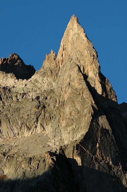
Aiguille Dibona 3130 m
Aiguille Dibona is an astonishing jewel, an emblematic summit of the Massif des Ecrins, so much to become its very symbol. A breathtaking peak, undoubtedly one of the most coveted mountain of the French Alps and one of the finest spires worldwide. Whatever is the route you have chosen, the climb on Aiguille Dibona is always a wonderful adventure, giving impressive views and unique sensations on perfect rock. When you discover the needle, as you walk through the Soreiller gorges, you will always have the same emotion, endless gazing to this jewel of the nature. No mountain is so extraordinary, no mountain has a so pure shape. It's difficult to imagine someone on the summit of such an arrow! Dibona symbolizes mountain climbing in a perfect way. Gaston Rebuffat himself wrote about Dibona: "This needle is a monument of stone given to mankind by the earth and the time, an extraordinary sculpture in the sky, the light and the silence of Oisans. The same achievements of the climbers on an other mountain would not be so marvellous. This needle was a question, climbing on it a response".
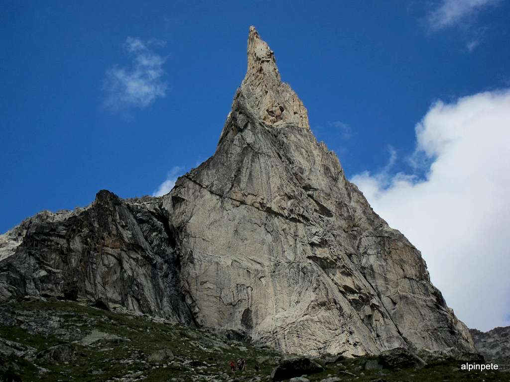
When seen from the path of the Refuge du Soreiller, the appearance of the summit is truly impressive in its rush towards the sky, like an arrow. Actually the Dibona is a granit blade placed side by side to the Aiguilles du Soreiller, and its spectacular profile seen from the hut path is a bit misleading: from the side the slender decreases and the back is it has a more massive and less impressive shape. Formerly known as Pain de Sucre du Soreiller, the spire was renamed in honour of the great alpine guide Angelo Dibona, who realized the first ascent of the peak with Guido Mayer on 27 June 1913, denying its fame of inaccessibility. At the foot of the mountain is the Refuge du Soreiller, accessible in 2h30m from the village of Étages.

Climbing History
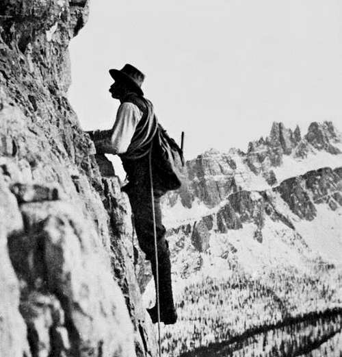
Angelo Dibona
This magnificent spire is dedicated to the great Angelo Dibona (Cortina d'Ampezzo, April 7, 1879 - Cortina d'Ampezzo, April 21, 1956) who was an Italian mountaineer and mountain guide. He is considered one of the best climbers of the twentieth century. He made an amazing array of new climbing around the Alps - seventy - from the Julian Alps, to Mont Blanc Massif and French Dauphine; here he is so famous for its new climb on Pic de la Meije Central, which has been granted the privilege of having two entire walls dedicated to him in the beautiful mountain museum of Saint Christophe en Oisans. Symbol of the Ampezzo mountain guides, it is dedicated to him a bust in the central square in Cortina, the work of sculptor Augusto Murer. He was appointed Alpine Guide in 1905 and he was also one of the first ski instructors of Cortina. More info: Angelo Dibona
Angelo Dibona - Planetmountain
- First ascent : Angelo Dibona and Guido Mayer (normal route today) 27 june 1913.
- First difficult route : Jacques Boell and Alain Le Ray 1932
- S face direct : Madier route : Madier and Maurice Fourastier 1937
- W and E faces : Maurice Laloue 1939
- S and W face : Savoyards route : Bernard Wyns and Pierre Chapoutot 1967
- Militaires route : Jean-Claude Marmier and Jean-Pierre Peters 1968
Getting There
The closest village is Les Etages, a little hamlet located 3 km before La Bérarde in high Veneon, a valley of Oisans Massif, department Isère. The Veneon can be reached from Bourg d'Oisans. From Les Etages you must reach the Refuge Soreiller 2730 m., the starting point to climb all the routes.
Road access to Bourg d'Oisans
- Coming from France Nearest airport : Lyon Satolas Station : Grenoble - From Grenoble, N 85 (Napoleon street) to Vizille, then N 91 to Bourg d'Oisans. Then Venosc, St-Christophe en Oisans, Les Etages (shortly before La Berarde).
- Coming from Italy Nearest airport: Torino From Torino, highway to Susa, Col de Mongenèvre, Briançon, Col du Lautaret, La Grave, Bourg d'Oisans. 4 km before Bourg d'Oisans, turn to the left direction Venosc, St-Christophe en Oisans and Les Etages.
From Bourg d'Oisans by road: direction Briançon on RN 91, 4 km after Bourg d'Oisans turn to the right (Veneon Valley) - By bus: between Grenoble and La Bérarde, 3 buses per day in july and august. Rest of the year, only one bus on saturday on reservation.
Approach to Refuge Soreiller
Access to the hut in 3 hours from Les Etages. The trail starts at the entrance of the hamlet of Les Étages. Vertical gain 1200 m. The approach is relatively steep and this since the beginning. After an hour of laces and crossings to the left, we reach a gorge that keeps some snow for a long time at the beginning of the season. Just after crossing the stream, the view begins to open on the valley. The trail continues quite directly to the refuge that we see from afar. Next day, wake up is often at 5 h 00 and start time 6 h 00. There is no glacier to cross.

|

|
Routes Overview
Main routes

- North ridge Normal Route - PD
The normal route can be lengthened with Clochetons Gunneng traverse. Normal route has 3 sections : - From the Soreiller Hut to the Pinnacles Breach (3048 m) - Traverse under the Pinnacles to the Gunneng Breach (3080 m) - N ridge climb
- Voie du Nain - AD, 5a (a move) 150 m. The route joins the Normal on last two pitch.
South Face routes
- Coup de Bambou - TD +
- Madier S - TD See also SP route description
- Visite Obligatoire - TD+, 6a 350 m. See also the route description on Summitpost: Visite obligatoire
- Voie des Savoyardes TD, 6a
- Sept d'un coup TD+, 6c+>6a
East Face
- Ethique de la Joie TD, 6a+
West Face
- Caro Airline - TD-, 6a
Descent: an easy but very exposed climb leads to a belay with an abseil anchor, about fifteen meters below the summit on the North ridge. Two 30m abseils lead fifty meters above a col separating Aiguille Dibona from Clochetons Gunneng. Downclimb easily to the col, then follow the path on debris and snow (many cairns) going back at the shelter with a ride in a semicircle.

Red Tape

|
|
No permits, no fees required. Maybe a parking fee is due in full season. Aiguille Dibona is situated inside the Parc National des Ecrins. The usual restrictions and regulations that apply within the parks must be respected.

Climbing images
 |
 |
 |
 |
Hut
Situation: Haute Veneon, foot of Aiguille Dibona
Open: from mid june to mid september
Size: 92 places, 40 in the winter-shelter
Owner: Société des Touristes du Dauphiné
Guardian: Martine Turc
Getting There: from Les Etages
Hut's phone : 0033 04 76 79 08 32 Off Season phone: 0033 04 76 80 28 79
Martine Junique, ski teacher in l'Alpe d'Huez in winter, welcomes you. Her great grandfather was "père Gaspard" the first winner of the Meije.

|

|
Camping
- Les Fetoules * Le Plan du Lac (between Vénosc and Saint Christophe en Oisans, 10 km from Les Etages) 35 pl Brigitte & Bernard Teiller Tél. 04 76 80 23 99
- Camping Municipal *** La Bérarde ( 3 km after les Etages) 165 places Tél. 04 76 79 20 45
When To Climb

Climb the South face from late spring until early fall.
Mountain Conditions and info
- Bureau des Guides et Accompagnateurs du Veneon La Bérarde - Meije - Ecrins 38520 St Christophe en Oisans
- Summer Tél. 04 76 79 54 83 - Fax 04 76 79 23 12 - Winter Tél. 04 76 80 52 72 - Fax 04 76 79 58 42
Meteo
Guidebooks and maps
Guidebooks
"Selected Plaisir Climbs Of Switzerland 2012" by Sandro von Känel - Edition Filidor 2012 - This guidebook features 115 of the most beautiful Plaisir routes (multi-pitch 4b – 6c) from the French Dauphine in the Southwest to the Alpstein massif in the Northeast. Includes many photos and exacting topos by the author who has personally climbed every route in 2011
"Oisans Noveau, Oisans Sauvage - Livre Est" by Jean Michel Cambon
"Le Massif des Ecrins - les 100 plus belles" by Gaston Rebuffat (classic handbook)
Carte IGN : IGN Top 25 - 3336 Est
 |
 |
External Links
La Meije La Meije SP page
Barre des Ecrins Barre des Ecrins SP page