
-
 65633 Hits
-
 95.24% Score
-
 52 Votes
|
|
Mountain/Rock |
|---|---|
|
|
0.659°S / 78.714°W |
|
|
Mountaineering, Ice Climbing, Mixed, Scrambling |
|
|
Summer, Winter |
|
|
17267 ft / 5263 m |
|
|
Overview
The Illinizas are two mountains that hold the 6th and 8th highest Ecuadorian peaks titles, Illiniza Sur (5,263 m / 17,267 ft.) and Illiniza Norte (5,126 m / 16,818 ft.) respectively. They used to be one whole volcano featuring a crater, but eventually split up in two. These peaks are located 55 Km south of Quito, the capital city of Ecuador, in the Occidental Andean range.
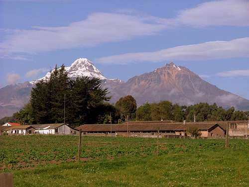
Illiniza Sur holds more humidity than Illiniza Norte, therefore Sur has a permanent snow and glacier and is suitable for experienced climbers with knowledge on technical gear and its use on steep snow/ice ramps, while Illiniza Norte is a less difficult peak to climb, where the deal is good hiking and scrambling skills.
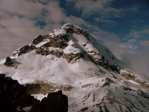
Illiniza Sur features steep ice/snow technical ramps (45 – 75 degrees) and it can be heavily crevassed depending on snow accumulation. The use of technical ice axes, crampons, a 60 meter-rope, a set of ice screws, snow pickets and a helmet is highly advised. You’ll be using the front points of your crampons for the most part of the climb, which it could be tired above the 5,000 m.
The difficulty of the peak can increase or decrease depending on the presence or lack of ice or snow and its quality on the ramps. Climbing Sur under mixed conditions could increase the difficulty of the climb and therefore objective dangers (rock/ice fall), while climbing on good compacted snow will minimize objective dangers and will increase the grade of success, safety and enjoyment of the climb. As it occurred during the last months of 2010, when climbing Illiniza Sur was exceptionally less difficult than climbing its neighboring peak. At that time, conditions and route quality in Illiniza Sur were excellent, compared with the ones of Illiniza Norte which were icy and instable.
Sadly Illiniza Sur has lost most part of its remaining glaciers, and it’s said that it could lost all of them by the end of the next decade.
Other than that, Illiniza Sur is a beautiful steep peak that offers great technical ice/snow climbing routes to visitors as well as stunning views of the surrounding mountains and valleys of the Ecuadorian Andes.
Getting There
From Terminal de Buses Quitumbe (south of Quito), take one of the several buses that leave to Machachi. There are only two bus companies that offer their service to Machachi, Transportes Mejia (green) and Carlos Brito (purple). You'll need to get off the bus at Mercado Central de Machachi.
Once in Machachi, take another bus to the town of El Chaupi (blue-and-white buses signed “El Chaupi”). They leave every 30 minutes from the Market’s corner. The best spot to catch a ride is at “Supermercados TIA”.
The statue of a woman milking a cow will let you know that you've arrived to El Chaupi (13 Km-bus-ride on a cobbled road, well actually half of it has been paved). From El Chaupi continue on a very well signed road towards the Illinizas parking lot at 3,900 m. (La Virgen, there's a small shrine to the virgin) which is about 9 km away.
From La Virgen Parking Lot (3,900 m / 12,792) follow the well-marked and signed trail that ends up at the northern moraine ridge of Illiniza Sur, 2 hours after leaving from the trailhead. Another trail continues up switch backing by the steep/sharp scree ridge.
Follow this ridge up for about 30 minutes - 45 minutes until the trail splits to the right (west) taking you to the Nuevos Horizontes refuge which is clearly visible from the upper part of the ridge.
 |
 |
 |
 |
 |
Transportation
There are two ways of getting to Los Illinizas:


Private transportation:
Transportation to La Virgen Parking Lot can be arranged at Refugio Los Illinizas Office located at the north side of the park in the town of El Chaupi or in La Llovizna Lodge. Their rates are USD. 10.00 one way (40 minute-ride).
Transportation from Machachi is not so recommendable, their rates are about USD. 25.00 one way and their service isn't efficient.
Transportation from Quito can be arranged in travel agencies for USD. 80,00 per day.
Public transportation:
Transportes Mejia and Carlos Brito leave every 20 minutes to Machachi from Terminal Quitumbe in Quito (USD. 0.55, 1 hour).
Transportes El Chaupi leave every 30 minutes from Machachi to El Chaupi (USD. 0.32, 40 minutes).
Red Tape
Starting Nov.12 2012 nobody is allowed to climb any glaciated mountain in Ecuador without hiring an accredited mountain guide. This restriction was issued by Ecuadorian Goverment after the last fatal accidents that happened in 2012 in Illiniza Sur and Norte.
Reserva Ecologica Los Illinizas entrance fee
There are currently no entrance fees for National Parks and Natural Reserves in Ecuador.
Refugio Nuevos Horizontes fee:
Foreigners: USD. 15.00.
Ecuadorians and residents: USD. 7.50.
Meals can be purchase at the refuge for USD. 7.00 each.
Routes
Approaching
After leaving from the refuge continue hiking up towards the saddle. You’ll find two small rocks that have been marked with the words “Norte” and “Sur” in order to set visitors into the right path. Keep your left and continue hiking up towards Illiniza Sur’s flanks.
You’ll be gaining altitude pretty fast as you keep hiking through the moraines. After about 20 minutes of hiking you’ll find to a green pond and a flat area, which it’s used for many climbing parties as a campground. This is also the junction for the East Ridge (Celso Zuquillo) route.
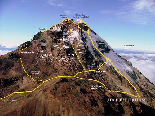
Illiniza Sur Topo Photographic Map.
Continue west on the trail for about ten minutes until reaching a small plateau. You’ll see a steep gully Ramp Route (La Rampa) at your left side. Make a short traverse a few meters beyond where you’ll find the right spot to start your climb, depending on mountain conditions.
To continue on the Normal Route stay left and traverse across rock/ice slopes and below La Rampa route itself to the far end of this icy slopes where you’ll find an obvious rocky gully (45 degrees) which is the entrance to the upper moraine terraces and northern glacier. Don’t approach to the glacier by this route in case of rock/ice fall presence, instead take the variant route which starts at the plateau (right path) and continues on a well cairned moraine crest slowly dropping to the talus below. Make a traverse west up to a sandy gully and climb it up to the lower glacier. Once there, make your way up to the upper glacier (normal route junction).
-Normal Route, North Face (Grade III/AD):
After reaching the upper northern glacier, traverse 50 meters diagonally up to the west to the crest, in order to avoid huge rocks ready to fall above the moraines. Use caution, this area is well crevassed. Once there, start your climb on the first long ramp which turns a bit steeper as you gain altitude.
You’ll crossed a small crevasse (most of the time covered) and you’ll be on a relatively flat platform where you can catch your breath and get ready to continue on the second steeper ramp. This one ends up on a big/deep crevasse. Up here, you may need cross it, and climb a very steep ice/snow wall (depending on conditions) up to the next wide platform.
You’ll see a rock band. Depending on snow/ice conditions choose to climb by the right (more exposed) or left side of this rock band on the last steep ramp which will take you all the way to the summit.
-Ramp Route, La Rampa (D/D+):
This is one of the hardest routes on Illiniza Sur. It starts a few meters beyond the plateau (see approaching). You’ll be climbing on an ice/snow ramp of approx. 80 degrees all the way up to a rock band which is the lower part of Cumbre Ambato or second summit.
You may need to negotiate it by either surround it to your left or climb it to your right. You’ll get yourself on the corniced summit. The true summit could be seen to the west. Down climb down from the summit and head west towards the true one. Traversing below El Hongo (Rock formation) and on the cornice saddle between both summits could be tricky. Use caution. Descend via the normal route.
This used to be the normal route back in the early 90’s. It stopped being climbed in 2005 – 2009 due to glacier retreading. Very few Ecuadorian teams climbed it again in 2010 taking advantage of the new loads of snow featured on the mountain in that year for less than a month. This route is not currently climbed.
 |
 |
 |
 |
 |
When To Climb
Although you can climb in Ecuador year round, the best time to climb in Ecuador are during the dry months of December, January and February. But sometimes this dry weather in these tropics is a joke, since it can change anytime. Anyhow, it rains less in the mountains during those times. June, July and August may be good months to climb too, but windy.
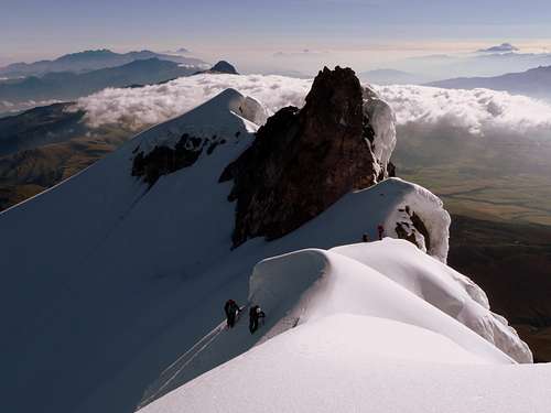

Climbing up the third ramp. Normal Route.
As I said, climbing conditions on Illiniza Sur could depend on snow accumulation and its quality, however, caution must be observed and an early start is needed since conditions can deteriorate later during the day. Climbing Illiniza Sur after a recent heavy snowfall might be not recommended due to the risk of avalanches which are very common on the peak. Please ask about mountain conditions at the refuge or in Llovizna lodge in the town of El Chaupi.
Some useful tips:
Start your climb early. It takes about 3 – 6 hours to reach the summit. Most parties start from the refuge at 4 am (at the latest) in order to get back to the refuge at noon. Weather normally turns in the afternoon hours.
Rope up at the glacier entrance, or at the plateau, before attempting the traverse if the conditions on the slopes are icy. Always use a helmet.
You’ll be using the front points of your crampons for most part of the way up to the summit. Make sure they are sharp and you dominate this technique and the use of two technical ice tools before attempting this climb. Front pointing might be a very tiring technique at these altitudes.
The difficulty could increase or decrease on the ramps depending on ice/snow conditions as well as the grade of inclination, usually between 50 – 80 degrees. The use of snow pickets and ice screws might be a must, especially on the way down. You might have to belay your partners on those exposed ramps.
 |
 |
 |
 |
 |
 |
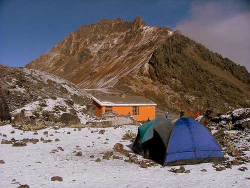
Camping and Refuge Info
The Nuevos Horizontes refuge is located at 4,700 m (15,416 ft) at the norther flanks of Illiniza Sur. It is considered the smallest high altitude refuge in the Ecuadorian Andes. Strategically built right on the saddle between Illiniza Sur and Illiniza Norte, it is the best option for those who want to push for the 6th and 8th Ecuadorian highest summits respectively, as well as for acclimatization purposes.

The refuge is being renovated by the new administration staff (Fernando Iza and Juan Pablo Vargas). Bunk beds, mattresses, table, kitchenware and even toilets have been replaced for new ones. Projects of extending the refuge facilities are being considered.
Other lodges / campgrounds
Hostal La Llovizna:
One of the best places to spent the night at, with warm bedrooms and hobbit-sized garret rooms, fire places, kitchen, Tv and ping pong table. Many of the parties and climbing teams start their ascension to Illiniza Norte from here. Its owner, Bladimir Gallo is the ex-manager of the Nuevos Horizontes refuge. He can arrange 4WD transportation up to La Virgen parking lot as well as guided hikes, climbs and horses.
La Virgen Campground or Bosque de Polilepis:
A few meters beyond the parking lot, there's a flat area which can be used as a potencial campground. Water is available at a nearby stream below the creek. Many parties start their ascension to Illiniza Norte and Sur from this area. Is not recommendable to leave your items unattended while climbing.
Illinizas Campground:
Located at the eastern side of the Nuevos Horizontes refuge. By setting up your tent here and paying the USD. 5.00 fee (per tent), you are entitled of using the refuge's facilities; kitchen, restrooms and water.
Glacier campground:
There's an optional campground just 50 meters beyond the refuge at the foothills of Illiniza Sur. It is located right next to a green lake in a flat area. No fees charged.
For more information about camping and the refuge, click here.
 |
 |
 |
 |
 |
Miscellaneous Info
Guidebooks:
Ecuador: Climbing and Hiking Guide, 6th Edition, by Rob Rachowiecki and Mark Thurber, (2008)
Ecuador : A Climbing Guide by Yossi Brain. (September 2000)
Maps:
The maps can be found at Instituto Geografico Militar (IGM) at El Dorado, Quito. They are about 4 US Dollars each and you must buy the maps in person.
I am providing a grid system for the maps, using the distribution that the IGM uses (below). Use this grid to get your maps.
Omnimap also sells the maps in the Unites States, but for about 14 Dollars each. In spite of the high price, they take their time to get the maps, so if you need them ask them with enough time (2-3 months or more)
The map reference is
Ecuador National Code CT-Ñ IIIC4
Sheet name "Machachi"
International code #3892-2
Escale 1:50000
 |