
|
|
Mountain/Rock |
|---|---|
|
|
46.49000°N / 121.4074°W |
|
|
8184 ft / 2494 m |
|
|
Overview
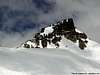
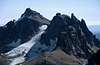
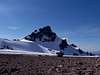
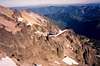
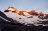
Gilbert Peak (formerly known as Mt. Curtis Gilbert) is the highest point in the Goat Rocks. It has two small glaciers. The Conrad is more active than the Meade. The Meade is on the southeast side while the Conrad is on the northeast side. The highest point in the Goat Rocks used to be known by that name but was renamed Curtis Gilbert in 1949 in honor of a Yakima Boy Scout leader. On the 1904 map it was called Gilbert Peak and had an elevation of 8,201 ft. This is the elevation stamped on the summit benchmark. Where the 8,184-ft elevation comes form I have know idea other than that's what now appears on the map.
The Goat Rocks, as Fred Beckey relates, are "a jumble of spires resulting from violent volcanic action, followed by periods of rapid cooling." The whole of the area was once a large volcanic area now greatly eroded. It may be indicative of the fates of Mt. Adams and Mt. Rainier eons from now.
 |
 |
 |
 |
Getting There
The Goat Rocks Wilderness is located in the southern Washington Cascades about 10 miles south of White Pass. There are two main ways to get to Gilbert Peak: via Conrad Meadows to the east and Snowgrass Flat to the WNW. A third approach is via Nannie Ridge Trail southwest of the peak.
To get to Conrad Meadows, drive US-12 east from White Pass 19 miles to just short of Hause Creek Campground. Turn right on South Fork Tieton Road No.12 (check road numbers haven't change). This road heads southwestward. At 4.5 miles turn left on road No.10 and stay with it through all junctions. At 18 miles the road is gated. This is the edge of private property. Park here (elevation 3900 ft). A map of the Goat rocks wilderness is needed from here on because there are many spur trails, game trails, and livestock trails in the area (it is cattle grazing area so watch out for cowpies).
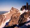
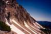
The second approach is from Snowgrass Flat and is used for western routes. Drive US-12 south from Packwood 2.5 miles and turn east on Johnson Creek Road No.21 (again, check road numbers haven't changed). At 15.7 miles turn left on road No.2150 and at 18.5 miles turn left on road No.(2150)014. In 19 miles from Packwood is the trailhead (elevation 4,600 ft). Take the trail to Cispus Basin then mount the ridge closely NNE of Cispus Pass (north of Pt. 6872). From the ridge, contour around the basin that heads the Klickitat River and then climb the first gully. This gully's apex is a basin below the sharp pinnacle of Little Horn. Turn right and cross moderately steep snowfields or talus (depending on season) until you get to the obvious shoulder on the southwest side of precipitous Goat Citadel (see this picture). Once around the corner there is a slight descent to a saddle. The rest of the climb is fairly trivial. Some Class 3 scrambling is required to attain the highest summit block, which is on the south end.
Another approach, and a mile or so shorter than the Snowgrass Flat approach, is from Walupt Lake (elevation 3,926 ft) to the south. Though shorter, this trail starts 700 ft lower than the Snowgrass Flat approach. Find the Nannie Ridge Trail at the west end of the lake. The trail goes up to 6,106-ft Nannie Peak then continues northeastward along the ridge to a trail junction at tiny Sheep Lake. Go left at the junction and contour high above the head of Nannie Creek. At a saddle closely north of Pt. 6512 (about 1 mile from aforementioned junction), leave the trail and cross the saddle to the northeast side to meet the PCT as it climbs above the head of the Klickitat River. This shortens the approach to Cispus Pass by about 1.7 miles. Cispus Pass is 1 mile west of Gilbert. Proceed as per the previous paragraph.
 |
 |
 |
 |
 |
Red Tape
A parking pass is required and you have to fill out a wilderness pass at the trailhead. Goat rocks is a popular place so rules and regulations are posted at trailheads.
When To Climb
June through November is best, but early season approaches and ascents depend on the amount of snow for the given year.
Camping
Camping is allowed in both areas but both are very popular. Please camp in designated sites or take care not to damage native flora. The area is prone to human-induced erosion--especially in Conrad Meadows.
 |
Mountain Conditions
 |
 |
liddlebigguy - May 8, 2008 8:02 pm - Hasn't voted
Please camp in designated sites or take care not to damage native faunaShould be flora
Klenke - May 8, 2008 9:28 pm - Hasn't voted
Re: Please camp in designated sites or take care not to damage native faunaNo, I don't want people to pitch their tents on a marmot. Geez... Thanks, I'll fix that.
jupsal - Sep 11, 2018 12:57 pm - Hasn't voted
Is scrambling in this area really allowed?I have concerns about scrambling in this area, and in particular the route starting from Cispus basin. If you start from Cispus, you certainly need to enter the Yakima Indian Reservation, which is supposed to be off limits to all. If you start in Conrad meadows you can probably make it to the peak without entering the reservation, but you can't explore much. Am I missing something, or should this not be advertised as it is illegal (not to mention disrespectful).
Klenke - Sep 12, 2018 12:17 pm - Hasn't voted
Re: Is scrambling in this area really allowed?Your concerns are much ado about nothing. Sure you enter an extreme outlier corner of the reservation but I'm fairly certain they don't or wouldn't care. There were no signs even telling you you've entered the reservation, at least as far as I recall or have seen mentioned on the Internet. You should be more concerned with the footing getting up the loose gullies to get up onto the final ridge where the going gets easier.