
-
 19543 Hits
-
 86.85% Score
-
 23 Votes
|
|
Mountain/Rock |
|---|---|
|
|
46.16940°N / 10.94150°E |
|
|
Hiking, Trad Climbing, Big Wall |
|
|
Summer, Fall |
|
|
7670 ft / 2338 m |
|
|
Overview
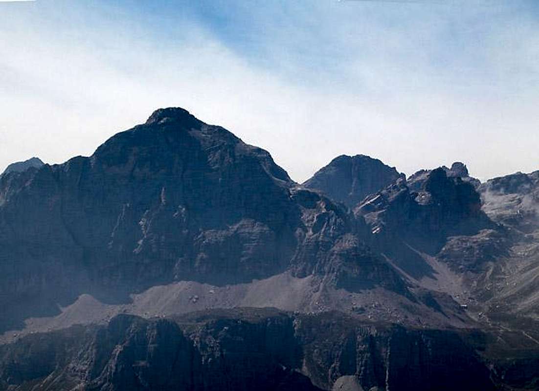
 The backside of the Croz. A bit lofty on top but otherwise easy. The backside of the Croz. A bit lofty on top but otherwise easy. |
Croz dell'Altissimo is a rather easy mountain within the Brenta Dolomites. It stands out high above Lago Molveno on the eastern ranges of the Brenta. Though you can reach the summit rather easily the crowds seem to stay awy from it. This might be due to the fact that hiking maps don't show the path to the summit.
What stands out about this mountain is not it's height or the lofty paths aound it but the sights and vistas that you have from up there. On a fine day you have perfect views towards the peaks of the centra Brenta, the Lago Molveno as well as the Dolomites proper. Moreover there is a near vertical drop of roughly 1000m towards its base which makes you wish you could fly.
 |  |  |  |
Summit panorama
Dos di Dalum (2689m)Monte Daino (2685m)Cima di CedaOrientale (2757m)Occidentale (2767m)Croz del Rifugio (2615m)Cima Brenta Alta (2960m)Crozzon di Brenta (3135m)Campanile Basso (2883m)Campanile Alto (2936m)C. del Sfulmini (2910m)Torre di Brenta (3013m)Cima degli Armi (2951m)Castello Alto dei Massodi (2430m)Cima Molveno (2917m)Cima Mandron (3040m)Cima Brenta (3150m)Cima Sella (2946m)Rocca di Val Perse (2760m)Cima Roma (2837m)Cima della Vallazza (2810m)Campanili degli ArmiC. degli Armi Bassa (2749m)Castello (2528m)Naso dei Massodi (2647m)Spallone dei Massodi (2999m)Cima Baratieri / Punta Iolanda (2784m)Cima delle Val Perse (2811m)
 | 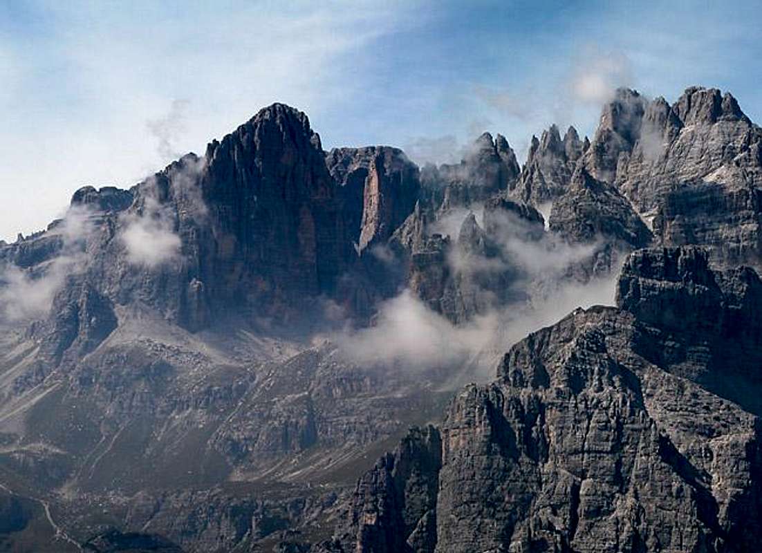 |  |  |
Summit view Croz dell'Altissimo. Central Brenta seen across Val delle Seghe.
2000m across, 1500m deep, the view into Val delle Seghe would be impressive enough. It is eclipsed, however, by the full view Brenta panorama as shown above.
Getting There
Take the Brenner Motorway A22 to the exit Mezzolombardo/San Michele all'Adige. Get on S43 through Mezzolombardo and after Rocchetta turn left onto S421 which leads through Andalao to Molveno. Molveno is pittorequely situated at the shore of the lake that carries the same name (868m). To get to the trailhead take the telecabina (a two person standup lift) to Rifugio La Montanara.The first stage ends at the Rifugio Pradel from where you can take the long ascent route through the Valle delle Seghe and Passo dell Clamer. If you decided on the shorter but steeper ascent via Passo dei Camosci you should take the second stage of the lift which takes you up to the Rifugio la Montanara at 1525m of altitude (the area around the refuge is very crowded but 15 min on the trail will leave you alone).
The two ascent routes can be combined to form a neat circle. For the whole trip you must calculate 6 to 8h (depending on whether you can ignore the vistas or whether you have to stop at each viewpoint to take your photos).
 |  |  |  |
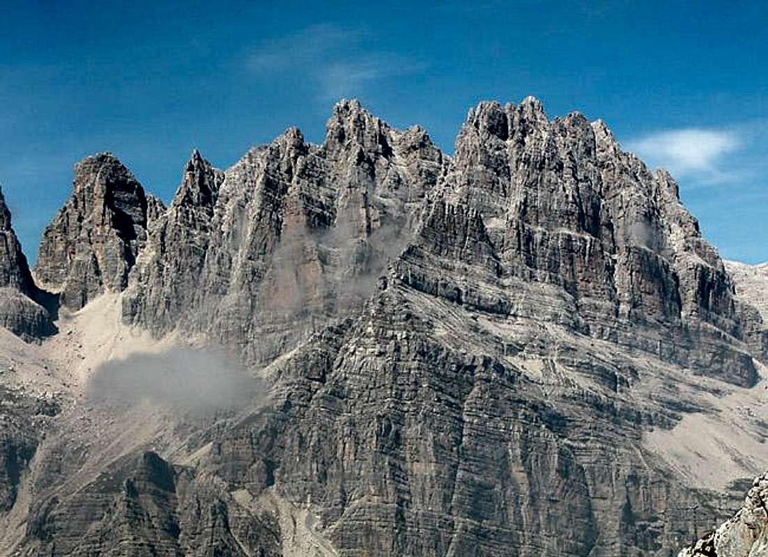
Climbing the big wall
Gabriele Roth provided me with the following information on the climbing routes of the big wall of Croz dell'Altissimo (compare the routes with the routes on the pictures):S wall of the shoulder
- Loss-Destefani - 650m - V,VI (200b)
- Laritti-Giogno-Rainis - 650m - IV,VI, A2 (200ba)
SW pillar of the shoulder
- Stenico - 650m - V (200c)
SW diedre
- Armani-Fedrizzi (the finest) - 650m - V+,VI (200d)
South wall
- Oppio-Colnaghi-Guidi - 650m - V+,A2 (200e)
W wall
- Dibona-Mayer-Rizzi - 800m - IV+,V+ (200f)
S wall variants (joins to Dibona 300-400m under the summit)
- variant Fedrizzi - 400m - V+ (200fa)
- variant Steger - 350m - V+ (200fb)
- variant Detassis - 450m - IV,V+ (200fc)
SSW wall to NW summit
- Pilati-Chini - 800m - V+,A2 (200g)
- Detassis-Giordani (looks like Solleder to Civetta) - 820m - V+ (200h)
SW wall
- Pianta-Mazzoleni - 850m - IV,V (200i)
 |  |  |  |
Red Tape
There are no limitations. You have to remember, though, that Croz dell'Altissimo is situated in the Parco Adamallo Brenta and thus you should behave as required within any natural park. Camping is allowed only in the vicinity of the refuges but you should ask the proprietors first. |  |
When To Climb
You can climb Croz dell'Altissimo all year round the best season should be May through October though. Both hiking routes are open for tour skiing in winter.Accommodation
There is a campground in Molveno near the lake.
You can chose among a variety of accomodations (hotels/rooms/B&B) in Molveno.
Azienda di Promozione Turistica
Piazza Marconi, 1
38018 - MOLVENO (TN)
Tel: 0461 586924
www.molveno.it
At the base of Croz dell'Altissimo you find the Rifugio Croz dell'Altissimo:
Altitude 1430m
Beds 19
Tel.: 0368 989242
Open: 01 July – 30 September
Weather Conditions
Weather and avalanche conditions in Trentino: www.meteotrentino.itMaps 'n' Books
MapsAn excellent map is:
- Gruppo di Brenta
Kompass Map WK 688
1:25000
Kompass Verlag
ISBN: 3-85491-770-8
- Brentagruppe
Alpenvereinskarte No. 51
1:25000
Books
- Hiking
Brentagruppe (German)
Kompass Hiking Guide 957
Dr. G. Wagner
Kompass Verlag
ISBN: 3-85491-410-5
- Vie Ferrate
Klettersteige Dolomiten / Via Ferrata Dolomites
W. Höfler
Rother Verlag
ISBN:
3-7633-3096-8 (German)
3-7633-4815-8 (English)
- Climbing
Dolomiti di Brenta (Italian)
Gino Buscaini
CAI-TCI
External Links
- Map of the Brenta taken from DAVlifeAlpin
Map taken from the german Alpenverein
- Brenta maps from kompass.at
Two Maps from the Kompass company, scaled 1:30000 and 1:50000 respectively