
|
|
Mountain/Rock |
|---|---|
|
|
44.72520°N / 14.98000°E |
|
|
Hiking, Mountaineering, Skiing |
|
|
Spring, Summer, Fall, Winter |
|
|
5479 ft / 1670 m |
|
|
Google Earth
Since Google has blessed us with its magical Google Earth software you can visit any corner of the world from the chair parked in front of your computer. Thankfully Velebit is amazingly clear so you can discover its corners and see for yourself how it looks from the above and where are the places this page is dedicated to.Each geographical point of interest described on this page has coordinates on the top of its section. You can use these coordinates with Google Earth’s fly to search engine. Just copy the coordinates (like it is written, with coma) and paste them into fly to tab and press enter. And, of course, enjoy the flight!
Overview of the Group
 Rozanski vrh (1638m) & Alancic (1611m) from Jablanac on the coast
In the SW corner of North Velebit there is a bunch of beautiful and very panoramic peaks. Scenery of the area is very diverse and picturesque. It ranges from rocky seaboard slope to gentle undulating grasslands to tame and romantic beech forests. Peaks are similar; some are rocky, some grassy and gentle, some forested. Few are marked and easily accessible, most are unmarked and not so easy to reach. All this is gathered in quite small Alancic – Rozanski Vrh – Seravski Vrh group, which offers allot of beauty and stunning views, especially towards sea because several peaks belong among highest on North Velebit and are closest to the sea of them.
Borders of the group are well defined.
On the west is seaboard terrace of North Velebit which is squeezed between the rocky peaks of first step and the slope of seaboard streak of peaks, in this case our group. Terrace is at the altitude of around 1100-1300m and contains series of very beautiful meadows, a former pastures and places where people lived during the summers with their cattle. Meadows are surrounded with beech and black pine forests which are mixed on places with spruce and fir. Three of five important peaks of the group are located in the seaboard streak and above the terrace. Most beautiful and highest among the meadows on the terrace is the northernmost; Lisac Stanovi at around 1270m. It is NW of Lisac (1545m). Ripiste (1060m) and Vujinac (1110m) are smaller meadows and are west of Lisac. Next towards south are Struga (1170m) and Zelengrad (1200m) meadows and former pastures. Above them is beautiful Rozanski Vrh (1638m). Just south of Zelengrad seaboard terrace melts into the slope of Alancic (1611m) and disappears but immediately appears several hundred meters lower so Alancic has big uninterrupted slope towards the sea (west). Below it, some 900m lower, is Dundovic Pod (720m).
On the south border of the group is same valley or depression which makes the border between North and Mid Velebit. It begins with Alan pass (1375m), south of Alancic (1611m). It continues towards east but after few kilometers our group ends where side valley opens towards north. That valley makes western border.
On the west group is separated from Goljak (1605m) group by a valley which contains large grassy basin of Tudorevo while other half is forested (more about both is onVeliki Kozjak page). On the north valley opens into Veliki Lubenovac basin while on the south is Alan Pass road and valley between North and Mid Velebit. Pushed towards east sixth and last prominent peak of the group stands above this valley; Vucjak (1586m).
Northern edge of the group is widest and rises above two distinctive areas. On the west is southern end of Smrceve Doline/Cipala area which is large closed valley between seaboard streak of peaks (west), Alancic – Rozanski Vrh – Seravski Vrh group (south), Rozanski Kukovi group (east) and Zavizan group (north). This undulating closed valley is heavily forested and one of wildest areas on whole Velebit, completely untouched with only one marked path. More about it find on Rozanski Kukovi page. Two of five important peaks of this group rise above Smrceve Doline/Cipala valley; Seravski Vrh (1661m) and Goli Vrh (1670m). Eastern part of northern border is forested valley between our group and Rozanski Kukovi. On its western end are Smrceve Doline/Cipala area while on the east is Veliki Lubenovac basin.
In the mid part of the group, behind seaboard streak of peaks or east of them, is high undulating grassy plateau Rozano, placed above 1500m. This beautiful area, which is covered with flowers in late spring and summer and blinding white in winter, offers romantic views of inner Velebit. East of it terrain continues to be undulating with frequent funnel shaped depressions but is heavily forested and slowly descends into the western border valley.
Through the heart of the group, the Rozano undulating plateau, in north-south direction leads the only marked path; a section of famous Premuziceva Staza, which is also part of VPP (Velebit long distance trail), on the way from Rossijevo Skloniste refuge in Rozanski Kukovi to Alan pass. From it short branches lead to two of the peaks; Seravski Vrh (1661m) and Alancic (1611m). These two peaks are frequently visited by the hikers who are doing this section and especially Alancic which sees additional visitor from nearby Alan hut, which is most convenient base to visit this group. Other peaks of the group are lonely and almost not visited at all. Very few have reached their peaks. More about it in each peaks section.
Most convenient base to stay and visit peaks of this group is Alan hut. More about it and how to get there see on Satorina page. See Rozanski Kukovi group page if you are coming from that direction.
Note: Lat/Lon of the page is that of Alancic
 |  |  |  |  |
Views
 Sea view during sunset from Alancic
Views vary from summit to summit and are great all over the group. Especially beautiful are those towards the sea, mainly from Alancic peak, as other great sea view point, Rozanski Vrh, isn’t marked and is hardly accessible. Views are also beautiful towards inner Velebit where main theme is rocky or grassy peaks, undulating grassy plain of Rozano and vast forests as far as eye can see. Here are few examples although almost every photo on the page represents the views all over the group.
 |  |  |  |  |
Alancic (1611m)
44°43'50.97"N, 14°58'7.89"E Alancic (1611m) in different seasons from Alan
Alancic (1611m) (read Alanchich) is bulky peak, last in the seaboard streak of North Velebit. Its first south neighbor, Buljma (1451m), is across the Alan pass (1375m) and on Mid Velebit. On the north first neighbor is Rozanski Vrh (1638m) and undulating high grassy plateau Rozano, at around 1500m. On the east Alancic shows its most modest side which gradually descends into undulating forested area of the group. On the contrary western side is highest. Above Dundovic Pod (720m) on the seaboard terrace Alancic rises some 900m. At the altitude of 1358m there is a small rocky/grassy terrace named Ostrik (read Oshtrik). From it are amazing views towards the sea. From all but northern side slopes above Rozano slopes of Alancic are forested. Summit is grassy cone which rises above the beech forests that reach 1550m on the eastern and southern side. On the eastern and northern side fir smaller fir trees are also scattered. On the SW there is longer grassy slope. High seaboard slope has various vegetation which changes with altitude. Below beech belt various types of trees grow and slope is forested with oak, maple, hornbeam, pine and ash communities.
Alancic is only 6km from the coast (airline) above which it almost rises in one piece because seaboard terrace is quite narrow here. This means Alancic is closest to the coast of any Velebit peaks that exceed 1600m! What this means considering sea panorama doesn’t have to be particularly stressed.
Alancic probably belongs among most visited peaks on Velebit. There are several reasons for that. First close to its summit leads quite frequent and popular section of Premuziceva Staza (Premuzich Path) between Rossijevo Skloniste and Alan pass. Second it is located above one of the most popular huts on Velebit, Alan hut, which is accessible by car. And third easy access is rewarded by fantastic sea panorama, one of the best on Velebit, because Alancic is so close to the sea. But this doesn’t mean you’ll have to fight for your spot on the summit, which is very broad anyway. Velebit is not visited by hordes of people, not even at the peak of tourist season, so chances are high that you’ll be able to enjoy panorama alone on the summit, especially out of season. And main focus of panorama is beautiful Rab island which is on your palm and looked at from bird’s perspective. If there wasn’t Alan pass road, that enables you to drive to only 30-40mins away from the summit, Alancic would be quite tough byte as any Velebit peak of similar altitude. From the coast it takes 4.30-5h to the summit.

Approach to the summit of Alancic is possible from two directions. First option is from the east with short marked path that branches from Premuziceva Staza path some 40mins from Alan hut. Second option, which is unmarked, also leads from Premuziceva Staza path. Some 25mins above Alan hut, when path leaves the forest for a short while and there makes sharp serpentine, you’ll see grassy/rocky dome of Alancic above. Leave the path on the serpentine and over the open slopes reach the summit in some 15mins. This is better option when coming from Alan hut while marked option is better when coming from Rossijevo Skloniste refuge (Rozanski Kukovi group).
 |  |  |  |
Rozanski Vrh (1638m)
44°44'37.95"N, 14°57'48.14"E Rozanski Vrh (1638m) from seaboard terrace
Shinning white limestone rocky dome of Rozanski Vrh (1638m) (read Rozhanski Vrh) rises in the seaboard streak of North Velebit. First neighbor on the south is Alancic (1611m). They are separated by a pass through which Rozano, high undulating grassy plateau, opens towards seaboards side of the mountain. Rozano lies east of Rozanski Vrh. Between the pass and Rozanski Vrh there is also minor rocky peak, made of smooth white cliffs, which is like a side peak but quite well separated with a pass from main bulky summit. It is around 1615m high. On the north is Lisac (1545m) peak. Between them is Strugov Stan (1360m) meadow, former pasture. Western side of Rozanski Vrh is highest. It descends over 400m to Struga (1170m) and Zelengrad (1200m) meadows on the seaboard terrace of North Velebit. Both were pastures during the summer while on Struga there was whole small village of houses. Today they are hardly recognizable ruins and forest has taken allot of former meadows. Sides of Rozanski Vrh are under beech forests, which are mixed with fir and spruce, except eastern side above Rozano plateau which is grassy. But that side of the peak like all other sides above forest are under dense belt of dwarf pine which is hardly passable. Above the dwarf pine are bare white cliffs of summit dome.
Behind Alancic Rozanski Vrh is second closest peak to the sea on Velebit, of those above 1600m! Distance is only 6-7km (airline), which makes it first class sea view point. I would say it is even better than from Alancic because Rab island is better centered below and very beautiful group of islands north of Rab is closer.
Rozanski Vrh is one of the most beautiful and elegant peaks of North Velebit and wider. Because it isn’t marked, and hopefully it will remain, Rozanski Vrh is one of the least visited peaks on North Velebit, especially among those in group above 1600m. By a dense belt of dwarf pine and smooth rocky summit dome it is well protected from already a small number of those interested but less adventurous. Rozanski Vrh is only visited by those who love to wander and explore the unknown. My guess is that even a year can pass without human foot stepping on its summit. Those that reach it are rewarded by the fantastic panorama of the Adriatic Sea beneath and North Velebit behind, even better than from Alancic. This is best view point in the group! Famous Rozanski Kukovi group are seen in very different light from this unique position.
Easiest approach, if there is one, leads from Rozano plateau. Try to find the place where dwarf pine belt is narrowest and ride it till you reach open cliffs of summit dome. Approach from the seaboard terrace is very difficult because of complicated mix of cliffs, forest and dwarf pine.
 |  |  |  |
Seravski Vrh (1661m)
44°44'45.38"N, 14°58'35.13"E Seravski Vrh (1661m) from Rozano
Seravski Vrh (1661m) is nice grassy cone with rocky summit that rises on the northern edge of Rozano, undulating grassy plateau. On the north is southern part of vast undulating forested area of Cipala/Smrceve Doline (Cipala/Spruce Valleys). Seravski Vrh closes the area from the south. On the west, south and east Seravski Vrh is surrounded by grassy waves of Rozano. On the other sides of large former pastures neighbors of Seravski Vrh are Rozanski Vrh (1638m) on the west and Goli Vrh (1670m) on the east. Naturally these sides are grassy while northern side above Cipala area is forested with beech and spruce. Just around the summit there is belt of stunted beeches and spruces. Some make it to the very summit but don’t obscure the view in any direction.
Seravski Vrh is lonely peak which doesn’t belong to any of streaks which generally appear on Velebit, like nearby seaboard streak of peaks to which neighboring Rozanski Vrh belongs.
Like Alancic Seravski Vrh is quite frequently visited by hikers who are doing Rossijevo Skloniste - Alan pass section of very popular and famous Premuziceva Staza (Premuzich Path). It passes just 10mins below the summit of Seravski Vrh and there is marked branch which leads to it. It is worth to climb it because of wide and beautiful view which reaches all the way to South Velebit. Part of the Kvarner Bay area of North Adriatic and islands is visible across Smrceve Doline towards NW. Also white Rozanski Kukovi are quite close. Marked branch can be reached from 3 directions; from Rossijevo Skloniste refuge it takes 2h, from Alan hut 1.30h and from Veliki Lubenovac 1.30h.
 |  |  |  |
Rozano
44°44'25.38"N, 14°58'31.59"E On Rozano
Rozano (read Rozhano) is beautiful undulating grassy high plateau in the SE corner of North Velebit. 4 of 5 most important peaks of this group are placed on its edges. On the south is Alancic (1611m), on the west is Rozanski Vrh (1638m), on the north is Seravski Vrh (1661m) and finally on the east is Goli Vrh (1670m). Well, to be precise Goli Vrh is in the NE corner so much of the eastern side of Rozano is open towards the undulating forested area that after a while descend into Tudorevo basin. Rozano is above forest line. It is separated into two parts, western and eastern. They are separated by grassy ridge so from the western part eastern is not visible and vice versa. Western part that is close to Alancic and Rozanski Vrh is lower (around 1500m) while eastern part which is closer to Seravski Vrh and Goli Vrh is higher placed (around 1570m).
Eastern part of Rozano is crossed completely from the north to the south end by the section of famous Premuziceva Staza (Premuzich Path) between Rossijevo Skloniste and Alan pass. Whole section is amazingly beautiful and Rozano is its second highlight after section through untouchable Rozanski Kukovi.
Western part is pathless but since orientation is easy it isn’t a problem to move away from the marks and explore a bit. Most beautiful combination if you are going from Alan hut towards Rozanski Kukovi is to leave Premuziceva Staza on the serpentine at the foot of Alancic and climb its summit (more in Alancic section). From the summit of Alancic continue towards north and descent into western part of Rozano. Continue straight till you reach a pass between Rozanski Vrh on the left (west) and grassy ridge on the right (east). From here northern section of western part of Rozano opens so it is hard not to recognize the spot. From here turn right and gradually climb onto the pass in the right grassy ridge. It is in front of larger grassy dome. Just behind the pass you’ll meet marks and turn left towards Rozanski Kukovi. This way you’ll see both western and eastern parts of Rozano. You can do just the same in opposite direction just reverse the description.
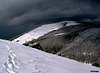
Rozano is romantic and very beautiful in each season. At the beginning of June both grass and beeches are fresh or fluorescent green, meadows covered with many flowers. Deep blue Enzians are especially noticeable. In autumn Rozano is bright yellow, like a vast prairie, with burning beech forests on the east and south. In the winter Rozano is blinding white as often sunlight is reflected from its hard packed or icy surface, smoothened to perfection by often hurricane force Bura wind. Although this isn’t a peak but plateau views are open and wide. Even distant South Velebit is visible.
 Winter vista from Rozano
 |  |  |  |  |
Lisac (1545m)
44°45'12.64"N, 14°57'6.20"E Lisac (1545m) from Ostrik
Lisac (1545m) is placed in the seaboard streak of North Velebit and stands in the NW corner of the our group. Its nice rocky cone, which rises above dark forests, pushed far towards sea, is visible from many parts of North Velebit. Like Alancic and Rozanski Vrh Lisac is very close to the sea, even closer than those two peaks. Western side of Lisac is melted into seaboard side of North Velebit which here descends to the coast almost uninterrupted because seaboard terrace almost disappears here. Side is rocky and torn. Last few hundred meters below the summit of Lisac are forested with beech. On the north is Lisac Stanovi (1270m), a larger meadow and most beautiful on the seaboard terrace of North Velebit. From it is beautiful view towards Lisac and towards the sea and islands. Here it is possible because crest of first step, which closes seaboard terrace from the sea side, here disappear and melts into the body of Lisac. On the east is southern part of vast Cipala/Smrceve Doline forested area. On the south is another larger meadow, Strugov Stan (1360m) which is placed in the passage area between Lisac and Rozanski Vrh (1638m). Through this passage former summer village of Struga (1170m), which is on the seaboard terrace, was connected with Cipala/Smrceve Doline. As from western side Lisac is surrounded with the forest from all other sides too. Here beech forest is mixed with spruce and fir. Summit dome is bare. It is mix of rock and grass.
Lisac is loneliest and remotest peak in the group and one of loneliest on whole North Velebit. To reach it one needs to have good orientation skills, will to go to the unknown and not to feel unpleasant in environment where there is almost no chance of meeting someone. Lisac is virtually unvisited peak. Like on Rozanski Vrh some years may pass without humans stepping on its summit. It is farthest away of 5 important peaks of the group from popular Premuziceva Staza (Premuzich path). Closest marked path is the one along the seaboard terrace of North Velebit which also sees very few hikers.
Most convenient trailhead for Lisac is Alan hut. From it head towards Plancice/Sica via seaboard terrace marked path. After some 40mins, when you descent from panoramic shoulder of Alancic called Ostrik, you are on the pastures of Zelengrad. From here you’ll notice a shallow rising forested valley between Lisac and Rozanski Vrh. From Zelengrad find a way to Struga former pastures which is at the foot of this valley. Behind the pass on the top of the valley, that is placed between Rozanski vrh and Lisac, descent to Strugov Stan meadows. From here left is towards the summit of Lisac.
 |  |
Goli Vrh (1670m)
44°44'42.92"N, 14°59'19.64"E Goli Vrh (1670 from Krajacev Kuk
Goli Vrh (1670m) is placed in the eastern part of northern edge of the group. It is in W-E line with Rozanski Vrh (1638m), which is in the seaboard streak of peaks, and Seravski Vrh (1661m). Between Goli Vrh and Seravski Vrh, which is its western neighbor, is northern part of Rozano, a high grassy undulating plateau. On the north is SE corner of vast Cipala/Smrceve Doline forested area and Krajacev Kuk (1659m) in Rozanski Kukovi. On the east and south are undulating forested areas that consist lot of funnel shaped depressions. From all sides Goli Vrh is forested with beech forest that is mixed with spruce and fir. Summit is above forest line.
Although Goli Vrh is bulky and highest in the group it is least significant and because of that last described. Marks didn’t reach its summit. Section of famous Premuziceva Staza (Premuzich Path) between Rossijevo Skloniste and Alan pass traverses its northern slopes but peak is rarely or not visited at all. Probably there are some years when no one reaches its summit. Easiest approach leads from Rozano area, where Premuziceva Staza leaves the forest and enters grassy spaces of Rozano.
 |  |
Getting There
Center of the region is Senj town on Velebit coast. Others are Krasno village on North Velebit and Jablanac on the coast below Alan pass. Public transportation can be used to access coastal trailheads while places in Lika are too far to walk from this part of Velebit.by Plane
Zagreb international airport is air gateway to Croatia. More info about flights find on official site of Croatia Airlines. From Zagreb you have to take a bus.
by Bus
There are several bus lines from Zagreb to Senj each day. Also there are lines towards Rab and Pag islands that after Senj continue along the Velebit coast till Jablanac (ferry to Rab) or Prizna (ferry to Pag). Detailed bus timetables from Zagreb find on Zagreb bus station site. If your line only takes you to Senj there you’ll have to wait for bus from Rijeka towards south.
by Car
This is always best possible option which gives you freedom to do and go wherever you want. There are three main directions to come to this area, from Rijeka, Zagreb or Zadar.
From Rijeka, along the coast
This route is suitable if you are coming from western Europe, via Trieste (Italy).
Trieste – Rijeka: 70km
Rijeka – Senj: 63km
Senj – Jablanac: 38km
From Zagreb
This road is suitable if you are coming from eastern or central Europe via Ljubljana (Slovenia), Maribor (Slovenia) or Budapest (Hungary).
Ljubljana – Zagreb: 138km, Maribor – Zagreb: 113km, Budapest – Zagreb: 347 km
Zagreb – Senj: 156km
Zadar – Starigrad Paklenica – Jablanac: 55km
Look for current road conditions in Croatia on the page of Croatian Automobile Club (HAK)


When To Climb
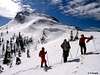
Learn about climate of Velebit mountain on its main page.Winter: in the high area described on this page winter lasts from mid November till May. In this period Velebit is under deep snow which reaches its peak in February or in March and lasts till May, sometimes even June. This changes from year to year. But even in this period after short periods of warmer weather in winter snow can remain only in patches on warm grassy southern slopes. To ascent any of peaks crampons are necessary because snow is usually transformed into white concrete, especiall on northern and eastern sides. Most dangerous factor is Bura wind which often reaches hurricane force. It brings terrible wind chill.
Spring: snow begins to melt faster in the second half of April but still falls frequently. Real spring begins in last third of May when greenery gradually reaches highest parts of the mountain. By the coast it will turn green between 15-20th of April while high placed beech forests will between May 20th and June 5th. End of May is fantastic time to visit as forest is fluorescent green. Flowers reach their peak during June.
Summer: lasts between mid June till end of August. July and August are real hell months on the coast with daily temperatures regularly around 35°C. Avoid day time ascent from the coast then because sun kills. On high elevations there is plenty of shade in the forests. Temperature rarely reaches 25°C in highest elevations. Temperatures usually range between 15-21°C. First snow falls every few years at the end of August but it doesn’t last long then.
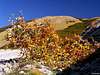
Autumn: in the highest area begins as September progresses. Colors are at peak between September 25th and October 5th. This is fantastic period to visit. By the coast colors reach peak only at the end of October or first third of November.
 |  |
Mountain Conditions
Conditions on Velebit are very well known thanks to Zavizan meteo station, which is observing weather since 1953. On WeatherOnline & DHMZ (Croatian Meteorological and Hydrological Association) sites you can find current data for Zavizan and even forecast for Zavizan on WeatherOnline.Here are the links where you can find out about the current weather on Velebit (Zavizan) and forecast for Croatia:
WeatherOnline:
WeatherOnline home page
Croatia at WeatherOnline,
Zavizan at WeatherOnline
Croatian Meteorological and Hydrological Association (DHMZ):
DHMZ home page
DHMZ Forecast page
DHMZ 7 Day Forecast for Croatian cities and places World wide, including Zadar and Gospic
Current Weather Conditions in Croatia including Zavizan, Gospic and Zadar (from 5-15h and 19-21h, during summer +1hour)
Snow Depth's in Croatia
Objects
Kuca na Alanu (1340m) (Alan hut) stands by the Alan road, 500m from Veliki Alan (1380m) pass, on the seaboard side. Hut is at the edge of the forest below Alancic (1611m) peak and meadows around pass. It was build in 1960 as foresters house. Forestry service gave 2 rooms to mountaineers to be used as refuge. In 1990’s it was completely handed over to mountaineers. It is open all year and managed in summer season when is partially supplied with drinks. You can prepare your own food in kitchen. It has 45 sleeping places in 4 rooms and water cistern. Hut is fantastic base to explore North and Mid Velebit.Visit Alan hut page on the web.
Dom Miroslav Hirtz (20m) is placed on top of 20m high cliff that rises above ferry berth in small bay of Jablanac village (learn more about Jablanac in its own section). Miroslav Hirtz hut probably ranks among lowest in the world. It was built before the WW II by Miroslav Hirtz. In 1955 Croatian Mountaineering Organization bought it from his ancestors and electrified it. In 1962 it was handed to mountaineers from Samobor who handed it in 1980 to MIV club from Varazdin. They completely renovated it. Today hut has 40 beds, 2 kitchens, water, electricity, TV and so on. It is open June 1st till October 1st and on arrangement by phoning Milan Turkalj (042 – 231764). Number at the hut is (053 – 887323). During season drinks and meals can be bought in the hut. Refuge by the hut is open all the time. From the terrace on which hut stands is beautiful view on Jablanac and North Velebit in the background with Lisac (1541m), Rozanski Vrh (1638m) and Alancic (1611m).
Camping & Accommodation
Camping is forbidden on Velebit except on authorized places like camps but none is in the vicinity of this area. On the mountain sleep in the huts or refuges. Here are few links to help you find accommodation on the coast and around Velebit.Adriatica.net, accommodation on Croatian coast
Senj town page
Karlobag place accommodation
Hotel Ablana, Jablanac
Marijana apartments, Stinica
Otocac town in Lika region (behind Velebit), accommodation list
Lika-Senj county, various info about nature, places, accommodations…
Red Tape
Group of peaks described on this page is inside North Velebit National Park so all the restrictions usual for NP’s apply. Movement is not restricted.Other Velebit pages on SP
~ Velebit massif, main page~ Zavizan area, North Velebit (Mali Rajinac (1699m) highest peak on the page)
~ Rozanski Kukovi group, North Velebit (Gromovaca (1676m) & Vratarski Kuk (1676m) highest peaks on the page)
~ Veliki Kozjak (1629m), North Velebit
~ Satorina (1624m), Mid Velebit (including whole area between it and Alan pass)
~ Stap area, South Velebit, (Debeli Kuk (1269m) highest peak on the page)
~ Visocica (1619m), South Velebit
~ Bojin Kuk (1110m), South Velebit
~ Viserujna (1632m) & Rujno, South Velebit
~ Paklenica area, South Velebit
~ Vaganski vrh (1757m), South Velebit (highest peak of Velebit)
~ Liburnija (1710m), South Velebit
~ Sveto Brdo (1751m), South Velebit
~ Tulove Grede (1120m), SE Velebit
~ Crnopac (1404m), SE Velebit
Note: Text on this and pages above is copyrighted and cannot be used in any kind of publications.