
|
|
Mountain/Rock |
|---|---|
|
|
36.29041°N / 50.77807°E |
|
|
Taleghan |
|
|
Hiking, Mountaineering, Bouldering, Scrambling |
|
|
Spring, Summer, Fall, Winter |
|
|
13534 ft / 4125 m |
|
|
Overview
see Map of Shah Albor areacentral alborz page
a picture from Taleghan (south face) :
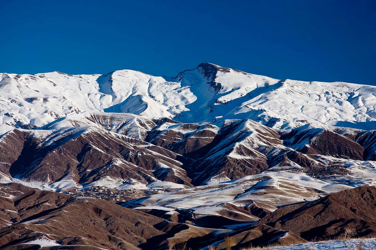
Shah Alborz is generally the name of a 20Km east-west 3500m+ ridgeline located more west to any mountain known as Central Alborz, some include it to Central Alborz and some West Alborz. These mountains incuding the lower mountains of south Taleghan are known as Taleghan mountains too.
The locals known the main 4125m peak that is the tallest giant peak on the range as Shah Alborz and leave most of the other peaks un named. The Taleghani people believe the height to be 4250m and they claim a group from Sepehr Electric(an Irainian industrial factory) have measured this number and they have put the 4250m sign on the peak. Anyway i put my trust on the numbers of Nader's maps.
Shah Alborz means King Alborz or maybe King of the Alborz.
A rocky peak named as Tanoorkhan or Tanoorakan at 3736m devides the main ridgeline into two sections.
(About the west section)
One is the west part that contains five distinctive peaks above 4000m including the tallest 4125m peak plus many 3500m+ peaks on sub ridge lines.
The north face of this part has eight small glaciers and rock walls under the ridgeline which drop steeply into Alamoot valley at 1400m to 1600m making the north face climb impressive (if done) and a fearsome view looking down when you stand on the ridge.
But the south face is not a big deal at a glance it is impresive when snow covered but actually its made of soft soil which is more like a rising sine wave of steep/not-steep hills making very long routs to the summits needing at least 2 or 3 days (summer), most of the year covered by thick snow, but summer the south slopes are more like a park on a slope ! grass fields and mountain flowers up to near the summit. the lower sub peaks or better say hills are mostly steep and rocky. the routes are made as narrow trails along these hills.
The west part rises from Alamoot valley at west makes a 3890m peak then an impresive peak 4089m names as (Alamoot peak) by the locals the normal route to this peak starts at Hasanjoon village and is a 3day walkup at summer.
then the unamed peaks : peak 4022m, peak 4042m and peak 4065m [the north view from Alamoot] there are several peaks and horns under 4000m sub peaks bellow these peaks on the main ridgeline. i believe the 4065m peak to have a name i have forgot but there is a sign and a branch toward this peak on the 4125m route, i don't remember the name but i think it was something like Zivarchal.
the last peak is the huge pointy 4125m peak named as Shah Alborz, the tallest peak of the range ! then the ridgeline drops slightly to about 3600m and then the rocky Tanoorkhan(3736m) peak.
(About the middle Tanoorkhan)
Tanoorkhan or Tanoorakan is the name of a peak and some know it as a pass, Tanoorkhan is a strange name, meaning Mr Tanoor(Tanoor is the fire place for making bread) and as i read in a book named Orazan by Jalal ale ahmad which was about Taleghan and Orazan village i realied Tanoor is the name of small caves the people made in the rocks of the mountain in the past, there where expert people who made this caves so water poured out and they put turbines and milds on the water for making flour of wheat...
anyway this 3736m peak starts a north-south sub ridgeline droping down by some rocky peaks, first a wall about 200m with 2 peaks at 3551m named AroosDoomad(Bride & Groom) the traildrops down to 1600m beside Khosban village.
(About the east part)
The east half is like a broad hump not steep from either sides. there is one 4003m peak named as Saat. the others (at least five) make 3800m, 3900m peaks on the hump. The south face of this section has beautifull villages and waterfalls, and good views of Naz/Kahar peaks.
Many streams and rivers come out of the Shah Alborz range. On the north face they join and define Alamoot rood river, on the south they join on the Taleghan river behind the Taleghan Dam lake. Most of the rivers are frozen at winter.
For the same heights Taleghan mountains have lower tempratures than the mountains around Tehran, Damavand and even the Takht-e-Soleimans.
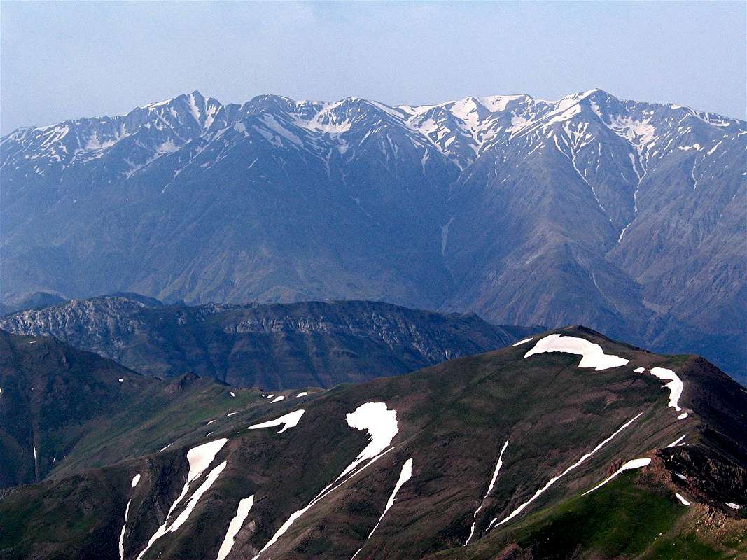
Nader's picture of the north face :
Getting There
from Tehran -> Karaj (by a 26Km highway) ->- (South face and Taleghan valley) follow the highway and go 49Km on Karaj-Ghazvin highway -> about 95Km far from Tehran the sign of Taleghan branch toward north can be seen, go on the branch, it will pass the lower south mountains into the valley of Taleghan after about 40Km. -> when you reach the valley follow to the village called Shahrak. The north part of Shahrak is totally covered by the Shah Alborz group, every village can be used for climbing up.
Normal route : there is a square at Shahrak go the north road then reach
Hasanjoon village (not far) the starting point of Shah Alborz normal route is
Hasanjoon village, you should climb out the village. to remain on the route can be confusing.
- (North face an Alamout/Moalem-kelayeh) follow the highway and go 99Km on Karaj-Ghazvin highway -> before reaching Ghazvin city turn up north toward Moalem-kelaye and Alamut -> After a long driving (85Km) reach Moalem-kelaye -> drive 30Km to Gazor khan village, follow the road and dont enter the branches, Shah Alborz mountains are located south to the road. Avanak, Rouch, Aveh are the villages located on the north slopes.
Red Tape
The whole Alborz mountains area and it's wild nature is a protected place hunting, fishing and abusing the nature is prohibited.This part is not a national park an dosn't need permit or fee.
If you see sheep groups be sure to call the shepherd, the fearsome guard dogs are free and dont hesitate to bite.
There is no problem for camping anywhere around, there are several shepherd on the south slopes at summer i prefere to camp near them to be secure of their dogs and other animals.
When To Climb
The climbing season is May - September. even the at summer Taleghan are can reach near 0C at nights so warm clothes should be included in the pack for night campings. Summer is windy at higher than 3200m. rain, hail frequant thunderstorms and lightnings happen.Winter climbing is a chalange, thick snow, avalanche danger, icy route, wild wind and other serve winter conditions of the mountains.
Trekking, hiking and taking pictures... i recomand a visit every season !