
|
|
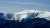
Mountain/Rock |
|---|---|
|
|
44.27059°N / 71.30327°W |
|
|
6288 ft / 1917 m |
|
|
Overview
Mount Washington is the highest peak east of the Mississippi River, north of North Carolina, and south of Ellesmere Island in North America. It is also one of most popular hiking, backcountry skiing, alpine climbing and ice climbing destinations in New England. Affectionately known as "the Rock Pile," it is located in northern New Hampshire just west of NH SR-16 between North Conway (to the south) and Gorham. It is also known as the "Home of the World's Worst Weather" and the world record holder for the fastest measured wind speed observed by man: 231 mph on April 12, 1934* (See the "Mountain Conditions" section for more). Today Mount Washington is known as the tallest peak in the Presidential Range which includes the 5 highest peaks in New England, but early on the entire massif was known as Mount Washington, a 30 mile long mountain running east to west. It wasn't until the 19th century that the surrounding peaks of Adams, Jefferson, Madison, etc. were named. A cog railway and road are also in operation on this mountain which hosts an observatory, musuem, and snack shop on the summit (so don't forget to bring your wallet).One of the shortest, most scenic, and most popular trails to the summit is the 4.2 mile class 2 Tuckerman Ravine Trail that starts at the AMC Pinkham Notch Visitor Center (2050'). The Lion Head Trail is probably the second most popular snow free route and the most popular route during the winter months. The Huntington Ravine offers challenging hikes, rock climbs, and ice climbs including: the Huntington Ravine Trail - considered one of the two most difficult hiking trails in the White Mountains; the NE Ridge of Pinnacle Buttress (5.7, 5-6 pitches); and a variety of winter ice climbing routes including the classic Pinnacle Gully (III NEI 3, 4-5 pitches), Odell's Gully (II/III NEI 2-3), South Gully (I NEI 1), and the Escape Hatch (I, popular descent route). The Lion Head, Huntington Ravine, and Boott Spur Trails all share the Pinkham Notch Visitor Center Trailhead with the Tuckerman Ravine Trail. See the Routes Overview Section below for a more complete routes list.
Mount Washington is known as the rock pile because the summit is composed of large blocks of New Hampshire quartzite and mica schist (Ref: injektilo) that you will have the privledge of hiking over during the summer. Winter offers a chance to get your crampons out of the closet travel up snow and/or ice instead. As you can probably tell by all the photos, Mount Washington is an extremely popular place for winter mountaineering, skiing and ice climbing, however, always check for current avalanche and weather conditions as over 120 people have died on this mountain (partial list with location and cause of death).
* Mount Washington's speed record is the fastest observed by man as well as the fastest in the Northern and Western hemispheres. Until 1996, it was also the fastest in the world, however in 2010, reports were published of wind speeds reaching 253 mph as recorded by remote sensors on the uninhabited Barrow Island during Typhoon Olivia.
 |  |  |  |  |
Routes Overview
Mount Washington has a plethora of hiking, ice, and ski routes. There are a few rock routes as well. The hiking routes ascend the mountain from all directions while ice climbing is generally concentrated in Huntington Ravine with some routes in Tuckerman Ravine and the Great Gulf. Spring skiing is concentrated in Tuckerman Ravine. Pinnacle Buttress (YDS 5.7) is a nice rock climb in Huntington Ravine.Any information related to filling in this table is highly appreciated.
| |||||||||||||||||||||||||||||||||||||||||||||||||||||||||||||||||||||||||||||||||||||||||||||||||||||||||||||||||||||||||||||||||||||||||||||||||||||||||||||||||||||||||||||||||||||||||||||||||||||||||||||||||||||||||||||||||||||||||||||||||||||||||||||||||||||||||||||||||||||||||||||||||||||
* NOTE on Ice Climb Ratings: All ice climbing technical ratings are labelled as WI (water ice) though they were originally rated on the NEI system. This is because ice climb technical ratings are now almost "universally accepted" according to Rick Wilcox (author of An Ice Climber's Guide to Northern New England) so that the NEI designation can be dropped. This would mean a route like Pinnacle Gully would be rated 'III 3', however, this leaves a lot to be desired for mixed routes where a technical rock and/or aid rating may also be used. To eliminate confusion, I have replaced the NEI designation with the more general American WI designation for the technical ice rating.
* CREDITS: Thanks to royswkr for difficulty ratings for Crawford Path, Davis Path, Dry River Trail, Glen Boulder Trail, Great Gulf Trail, and Jewell Trail.
NOTE ON BOOKS: ROUTES COVERAGE
The following is a list of books and the routes that they cover:
- An Ice Climber's Guide to Northern New England, 2nd ed. by Rick Wilcox: 7.1-7.2, 8.1-8.9, 8.11-8.13
- AMC White Mountain Guide, 26th ed.: 1-12, no decimal (variation) routes except 12.6.
 |  |  |  |  |
Getting There
PINKHAM NOTCH VISITOR CENTER: Pinkham Notch is the most popular starting point for the climb of Washington. Use this for the Tuckerman Ravine, Huntington Ravine, Lion Head, and Boot Spur Trails. It is located roughly halfway between Gorham and North Conway on Route 16. The visitor center at the Notch is well-defined and marked. To reach the auto road, go to the Glen House a few miles north of the Notch. The cog railroad can be reached by driving in on Mt. Clinton Road from Bretton Woods to the Marshfield Station - signs can be found near the Mt. Washington Hotel. |  |  |  |  |
Red Tape
PARKING PASS (MANDATORY IN SOME AREAS): Like many US National Forests, the White Mountain National Forest now requires a parking pass to park at many of its trailheads. A pass is required if you park in the National Forest including the overflow lots at Pinkham Notch. A pass is not required if you are parking in the Pinkham Notch parking lot proper. There are a variety of pass options ranging from a $20 annual pass to a $3 daily pass as of 2001. The USFS White Mountain NF Parking Pass Program page has more information on how you can order these passes. You can pay for the $3 daily pass at many trailheads. |  |  |  |  |
When To Climb and Ski
The snow free hiking season generally lasts from May to October though you can often find flurries as early as August. Be prepared for rain and wind during the summer months especially if traveling above treeline. During the winter months, outfit yourself mountaineering style with an ice axe and crampons. Also check out the:MountWashington.com: Winter Hiking page
The skiing is most popular here during the spring between March and May. Skiers should review the information on the NSI / USFS Tuckerman and Huntington Ravines FAQ. Ice climbers should check the EMS Climbing School Ice Climbing Conditions page under the Mountain Conditions Section.
 |  |  |  |
Camping
You can find established campsites at the Hermit Lake Shelters, the AMC Lakes of the Clouds Hut (5012'), and the Harvard Cabin. The Lakes of the Clouds Hut, located 1 mile southwest of Tuckerman Junction high on the mountain, is a full service hut that is open from June 1 to Sept. 15. During the winter months if you are caught in a jam you should be able to find emergency shelter here in a small "refuge room" that is kept open to provide protection against the wind and blowing snow.The Harvard Cabin, located about 2.1 miles from Pinkham Notch in Huntington Ravine, by contrast, is open only during the winter from December 1 to March 31. The fees are $15/night inside and $7.50/night outside. The cabin sleeps about 16 (but more can usually squeeze in if neccessary), has a gas stove for cooking, a wood stove for heat, as well as pots and other utensils. There's a caretaker at the cabin who collects fees and keeps the place going. Visitors that wish to stay at the Harvard Cabin must register by signing the logbook located in the AMC Pinkham Notch Visitor Center basement. Sign-up is on a first come, first served basis. Pets are not permitted overnight. To reach the cabin, head up the Tuckerman Ravine Trail, turning right on the Lion Head Winter Route, however, head past where the winter route turns left, instead crossing a small bridge to find the cabin on your right. Thanks to russki82 for information on the Harvard Cabin.
If you want to stay in the backcountry check out the WMNF Backcountry Camping Rules. Of special interest is that camping above treeline is only allowed during the winter on 2+ feet of snow and only outside of the Cutler River Drainage. This restricted area includes Tuckerman and Huntington Ravines as well as the general area east of the summit from Nelson Crag to the Boot Spur.
For detailed information on where to stay during the winter check out the Winter Overnights on Mount Washington page.
Additional links maintained on SP: White Mountain (NH/ME) links page
 |  |  |  |
Mountain Conditions
It's no accident that Mount Washington is known as having "the world's worst weather" - the USFS says so. The average annual summit temperature is 26.5°F with a historical range of -47°F to 72°F. Average snow fall is 256+ inches with a seasonal maximum of 566 inches so beware of avalanche danger during the winter, especially in Tuckerman and Huntington Ravines. Average annual mean wind speed is 35.3 mph or gale-force winds with hurricane-force winds occurring every 1 day out of 3. If you are ice climbing in Huntington Ravine, be careful of the weather up top since the ravine will often shelter you from bad weather above. Several unsuspecting climbers, upon reaching the top of the ravine, have been literally blown off the mountain (see the March 5, 1999 Mountaineering Accident Report below).If you come during the summer, you can expect low visibility on the summit, however, during the winter often the skies are clear. Use the following to check current conditions.
PINKHAM NOTCH VISITOR CENTER
P.O. Box 298
(on NH SR-16 just south of Wildcat ski area)
Gorham, NH 03581
(603) 466-2721
(603) 466-3871 FAX
Mount Washington Weather Reports: Mount Washington Observatory
Daily Summit Weather Report: Mount Washington Observatory
Avalanche Bulletin: Latest from USFS
Backcountry Weather and Trail Conditions (late fall to late spring): Mount Washington Observatory
Ice Climbing Conditions: EMS Climbing School
Ice Climbing Conditions: International Mountain Climbing School
2 Web Cams: Mount Washington Observatory
Tuckerman.org: Weather Page
MountWashington.com: "The world's worst weather?" Historical weather data.
USEFUL MESSAGE BOARDS
AMC Outdoors.org Website: Trail Conditions Message Board
Views From The Top: Current New Hampshire Trail Conditions
Miscellaneous Info
RADIO REPEATERSUse the following Ham repeaters for Mount Washington and the nearby area:
- Mount Washington: 146.655 Mhz -0.600 and PL tone of 100
- North Conway: 145.450 Mhz -0.600 and PL tone of 100
 |  |  |
External Links
- Tuckerman.org
The Mount Washington Volunteer Ski Patrol maintains this site in cooperation with the United States Forest Service to ensure that skiing, climbing, and hiking enthusiasts have access to current and accurate information regarding Tuckerman and Huntington Ravines.
- NEice.com
New England Ice Climbing web site includes information on routes, conditions, events, and articles.
- White Mountains Info Server
David Metsky's information packed web site on the White Mountains of New Hampshire.
- Deaths on the Peak
A neat site that shows you the 122 deaths that have happed on the Peak since the first one 1849. Unfortunately people just do not seem to learn there lessons as the deaths continue till 1997 at an ever increasing rate. I am sure there have been more in the last 5 years.
- Mount Washington, NH, by the Great Gulf Trail
- Mount Washington (NH) Hiking Trails
Information (distance, elevation gain, book time) on most hiking trails up Mount Washington.
- Southern Half of Presidential Traverse in Winter
- Mt. Washington weather, photos & general info
This is a great website to see current pictures from the summit, historical weather information, see photos from different times of the year and give general information.
- attempt via Tuckerman
- Time for Tuckerman
great site for skiing info in Tuckerman ravine. Real time cams, route/trail info, snow/avalanche conditions and a message board.