
|
|
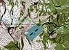
Route |
|---|---|
|
|
48.22270°N / 115.6885°W |
|
|
Scramble |
|
|
Most of a day |
|
|
II Class 4 |
|
|
Approach
Start at the Leigh Lake trailhead (4080 ft), directions for which are described in the Getting There section. After hiking for 0.75 mi on the steep Leigh Lake Trail you will arrive at a stream crossing (4970 ft) next to a waterfall on the left. Ignore the crossing and fork right up an even steeper use trail. This trail reaches Leigh Lake (5190 ft) 1.3 mi from the trailhead. Good campsites are available here.
 |  |  |  |  |
Route Description
Continue straight around the north side of Leigh Lake for 0.2 mi until you see a couloir, seasonally filled with snow, and a stream. Hike uphill on the right side of this gully through rocky hanging meadows to a crossing between waterfalls at 5560 ft. Traverse left and uphill through more meadows to the right side of another couloir. Follow the right side of this gully to an easy crossing at 6600 ft. Now traverse left through seasonal snowfields at an even elevation for 0.25 mi to the base of a gully (6680 ft) leading directly north through cliffs to the northeast ridge. This gully is the only weakness in the cliffs guarding the ridge, so look closely for it. Scramble through this often wet gully for 0.2 mi to the northeast ridge at 7310 ft.
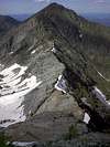
Turn left on the ridge here towards Snowshoe Peak. For 0.5 mi the ridge is second class with an occasional third class move. Exposure is generally severe on the left side with easy slabs on the right side. Be constantly aware of the loose rock. At 7640 ft the fourth class scrambling begins and continues for 0.35 mi to the summit ridge. Stay on top of the ridge when possible, skirting over to the right side if the scrambling seems too difficult. Low angle permanent snow reaches all the way to the ridge allowing you to bypass hard or exposed sections, especially near the top. Near the highest snowfield, traverse left on an exposed ledge to the summit ridge (8470 ft).
Follow the left side of the ridge, generally below steep towers on the right. Loose dinner plate rocks cover everything here; because of the slope aspect, the rock is much worse on this side of the summit ridge. Ascend though short cliff bands until a direct route to the summit comes into view. Easy third class scrambling will bring you to the summit (8738 ft). Entries in the Forest Service register here extend back through at least the eighties.
6.9 mi round trip
4660 ft elevation gain
 |  |  |  |  |
Essential Gear
Ice axe and crampons. During the summer you could probably get by with just an ice axe. If other people are around to kick down rocks a helmet is also recommended.