
-
 2615 Hits
-
 72.08% Score
-
 2 Votes
|
|
Route |
|---|---|
|
|
47.12240°N / 11.09480°E |
|
|
Hike / Scramble |
|
|
Most of a day |
|
|
Walk-up |
|
|
Route overview
| 1372m / 4501ft | |
| 3.5 - 5 hours (to the summit) | |
| about 8km | |
| Parking lot in Lisens |
Approach
Trailhead is the parkinglot in Lisens (1636m / 5367ft). Parking is not free there, but 2 Euros per day is not expensive.
Reaching Lisens is quiet easy by car via Praxmar and Gries im Sellrain. For more information visit the getting there section of the main page.
Route Description
After parking in Lisens you have to reach Westfalenhaus (2273m / 7457ft). There are two possibilities to do that:
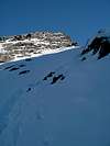
After you' ve reached Westfalenhaus (2273m / 7457ft) trail #143 leads up to Münsterhöhe and from there up to point 2508m / 8228ft. From there the trail gets quite steep. After 2h from Westfalenhaus (2273m / 7457ft) you' ll reach Zischgenscharte (2936m / 9721ft). From this pass the trail turns right (east) and the west ridge leads on to the summit. There is one section with a rope, which is fine if the rocks are covered by snow, but in summer this section offers no problems if you' re an experienced hiker.
 |  |  |
Essential Gear
Hiking gear is sufficient.
If you plan to do this trip in late autumn or winter be sure to be prepare for difficult conditions along hte ridge or the steep ascent to Zischengenscharte!
Miscellaneous Info
If you have information about this route that doesn't pertain to any of the other sections, please add it here.