Mt. Cascade via Upper Pole Coulior

Mt. Cascade via Upper Pole Coulior

Page Type Page Type: Trip Report
Additional Information GPX File: Download GPX » View Route on Map
Date Date Climbed/Hiked: Jun 21, 2014
Activities Activities: Hiking, Mountaineering
Seasons Season: Summer

Mt. Cascade: up via Upper Pole Couloir, down Dry Creek

Upper Pole Coulior
Hiked up June 21 via the Upper Pole Coulior. The snow (dirty mixed with rocks) was an issue lower down, but faded out higher up.  The grade and exposure was more
intense than expected, especially after exiting the Coulior and scrambling to the ridge. There were a million chipmunks in the Coulior.

Ramp
At the top of the Coulior is a "ramp" to exit out of the cliffs that surround the top.  From the ramp to the ridge line is very steep and without an obvious route to follow.  This part was so steep and rough, that we opted to not come back down this way.

Summit
We hit the North summit, then headed back down to where we hit the Ridge line.

Ridge
It's a long ways, several miles, along the ridge from the South Summit to the top of the Dry Creek Trail. A good spot to have gps or someone who knows the route.

Shingle Mill
Having a trail is super nice after all the scree and stair-stepping moves.  Shingle Mill peak is always fun to see.


Snow
Avalanche debris and felled trees blocked the trail below Shingle Mill Peak.  So it was a good thing we had hiked this part twice before.  Our GPX file may not be the best for this segment, but until the snow melts it may be useful.  For our route that goes up and down Dry fork, see here: https://www.summitpost.org/cascade-via-dry-fork/814620

A real challenge but a fun hike. Stats:

Distance: 13.6 miles
Elapsed Time: 10:35:27
Average Speed: 1.3mph
Moving Average: 2.0mph
Min Elevation: 6988 ft
Max Elevation: 10891 ft
Ascent: 5779 ft
Descent: 5792 ft

It took us about an hour and 45 minutes to get from the truck to the ramp (1935 feet of elevation ascent). 
It took us 3 hours to get from the truck to the ridge (3154 feet of elevation ascent). 
From the ridge to the peak and back took 1:51 (820 feet of elevation up and another 820 feet down). 
From there to the road took 4:19 (5.9 miles).  916 feet of ascent; 4217 feet of descent.  A
From the road to the truck took 1:24 (3.6 miles).  842 feet of ascent; 572 feet of descent.


Comments

Post a Comment
Viewing: 1-4 of 4
ZeeJay

ZeeJay - Jun 23, 2014 11:11 am - Voted 10/10
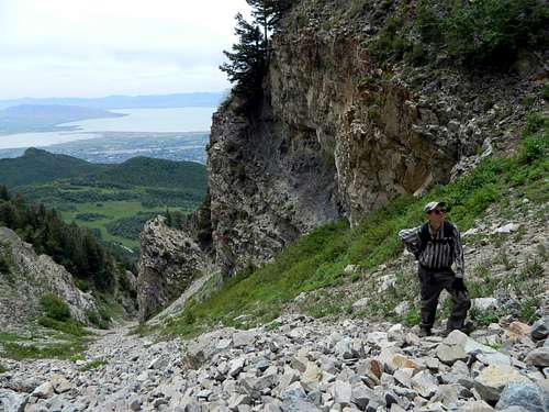
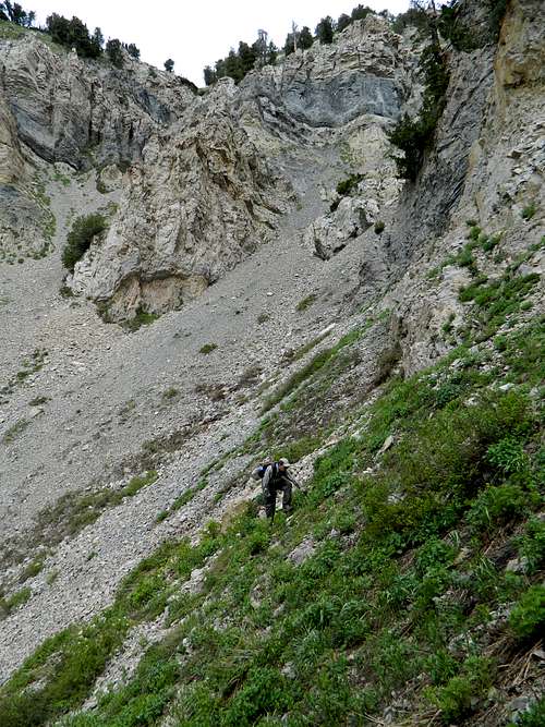
track

I took a look at your track. At the point you exited the couloir, if you had headed for the north ridge to your left, instead of the south ridge/right, you would have found the going much easier as it is significantly less steep and is pretty much a grassy slope up to the ridge.

rrigby - Jun 26, 2014 11:53 am - Voted 10/10

Re: track

It was a steep hike. My recollection is that it didn't look easy to cut to the left once we exited the couloir (which is partially why we headed for the south ridge but also because the track we were following headed roughly where we went). Any chance you have a gps track of the grassy slope up to the ridge? I'd be willing to give it another go. Particularly once the snow has melted in the couloir.

ZeeJay

ZeeJay - Jul 1, 2014 1:15 pm - Voted 10/10

Re: track

I sent you a PM.

Ryan Borzea

Ryan Borzea - Oct 10, 2016 5:15 pm - Voted 10/10

Re: track

Hi ZeeJay,
Any chance you'd be willing to share your .gpx file with me?
Thanks,
Ryan

Viewing: 1-4 of 4


Parents 

Parents

Parents refers to a larger category under which an object falls. For example, theAconcagua mountain page has the 'Aconcagua Group' and the 'Seven Summits' asparents and is a parent itself to many routes, photos, and Trip Reports.

Cascade MountainTrip Reports