-
 6416 Hits
-
 89.77% Score
-
 30 Votes
|
|
Mountain/Rock |
|---|---|
|
|
49.90639°N / 126.48722°W |
|
|
Mountaineering, Scrambling |
|
|
Spring, Summer, Fall |
|
|
5272 ft / 1607 m |
|
|
Overview
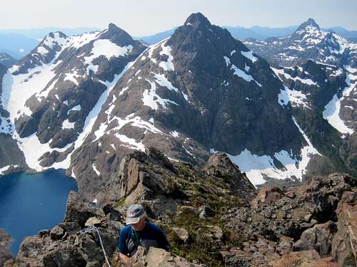
 Mt Grattan summit block and east aspect on the approach Mt Grattan summit block and east aspect on the approach |
The mountain is found in the north sector of the Sanctuary, north of Peter Lake and west of Shangri La Lake and can be climbed from either.
Mt Grattan northeast aspect
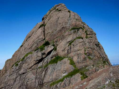
The steep ridges leading to the tiny summit are comprised principally of karmutzen pillow lava, a red/brown abrasive, grippy rock that offers friendly passage to the climber. A fortunate occurrence, since exposure on the routes is high and protection poor.
As with every high point in the Sanctuary, summit views both within the area and beyond to the Island ranges – particularly the Haihte Range - are somewhere between superlative and impossibly breathtaking.
Mt Grattan is named in memory of RCAF Flight Sergeant Noel Grattan, of Victoria, BC, who was killed in action in 1942, at the age of 21. Grattan's aircraft failed to return from a bombing mission over Cologne, Germany and was presumably shot down. The name was officially adopted July 20, 1978.
FRA: R Eppler, P Erickson, J Henderson, R Mcdonald June 1991 via the west ridge.
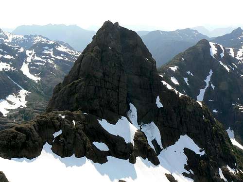
Mt Grattan on the left, west aspect from Mt Alava
Getting There
Vancouver Island can be reached directly by air from Toronto, Vancouver, Seattle, Calgary, Edmonton and recently San Francisco to Victoria and by ferry from Port Angeles to Victoria on The Coho and on BC Ferries from Vancouver to Victoria or Nanaimo. Public transport on the Island is notoriously poor and anyone arriving by air would be advised to rent a car.Access to the main points of entry to the Sanctuary involves logging road travel but on main lines. A 2WD vehicle would normally be expected to suffice.
Although the Sanctuary has been approached from the north via Sebalhall Creek, the main points of access are off the Gold River/Tahsis Road and only these will be dealt with here. From any point on southern Vancouver Island, drive north on the Island Highway 19 to Campbell River. From Campbell River take highway 28 west through Strathcona Provincial Park and onwards to Gold River. Just before entering the town of Gold River, watch for a right turn signed for Tahsis. It’s immediately after the tourist information office. Proceed 2 km on this road and across the bridge over the Gold River. Here the road splits. Right to Woss and left to Tahsis. Note this point on your odometer and turn left onto “Head Bay Road”. The pavement ends almost immediately, but this is good sealed or gravel road.
Drive about 27 km from the Gold River bridge and find Conuma Main on the right just after crossing the Conuma River. Drive this good main line about 11.5 km, passing the C15 access for Conuma Peak after 3.5 km and park at about N49 52.403 W126 24.954. The route to Shangri La Lake via the Conuma River approach starts here. Mt Bate towers above you to the northwest.
For the Perry Creek access to Alava and Peter Lakes continue 22 km past the Conuma/Head Bay junction and find Perry River branch road P15 on the right. Drive the road right to the back of the valley to where the creek crosses the road.
Approaches
Both approaches described below involve heavy bush and difficult travel particularly via the Perry River. These difficulties are in no small measure responsible for the few visitors that the Sanctuary has seen over the years.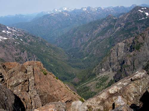
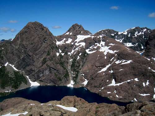
Pristine valleys to the north of Mt Grattan
Shangri La
From the start point travel west and then follow the river north up the steep sided canyon. The route has been recently (July 2010) flagged. Beware of a dangerous river crossing at N49 52.753 W126 26.725. A ramp at N49 53.766 W126 27.450 is used to bypass a waterfall about half way up the canyon. Travel time to Shangri La 6-8 hours.Alava/Peter Lake
Follow the creek through dense bush into a steep sided canyon. The route makes its way up rock slabs before reaching Alava Lake. Continue up to Peter Lake on the opposite side of the river. This route has been included in the list of top ten bushwhacks on Vancouver Island, which is saying something. Don’t say you haven’t been warned!The Airborne Alternative
Over the years a number of visitors have accessed the area via helicopter. The local ecosystems in the Sanctuary are delicate and fragile and, in this case, an air assist might just be the least invasive way to reach and stay there. See the “Camping” section below.Summary of Summit Routes
West Ridge
Accessed from Peter Lake. 300 Metres of exposed 4th Class on superb rock but with little protection.East Ridge
Accessed from Shangri La via the prominent snow couloir on the south flanks of Thumb Peak. 3 Exposed pitches up to 5.4 with poor protection.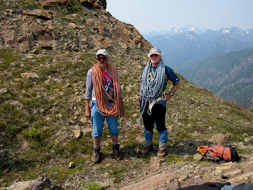
Mt Grattan first ascentionists
Red Tape/Safety Considerations
Mt Grattan and the Alava Bate Sanctuary could not be more removed from the need to consider red tape. Almost no-one goes there and few outside the climbing fraternity know of its existence. With this caveat, therefore, comes the need to consider safety.Unless you’re supremely confident in your abilities to look after yourself come what may, I would consider a satellite phone mandatory for trips into this wild and remote area. Make sure that you have left a detailed trip plan with someone responsible. The appropriate SAR agency will respond in an emergency but it is up to you to have the mechanism in place that will initiate the call-out process if it becomes necessary. Know your exact coordinates at all times. Consider personal limited range radios for communication within your group.
Camping
Most visitors camp at the outlet of Peter Lake or on the extensive gravel flats at the outlet end of Shangri La Lake. These, and anywhere else in the Sanctuary, are areas which are delicate in the extreme. Fires are absolutely out of the question – there’s no wood anyway. Tread carefully amongst the acres of flowers. Try to keep your footprint as low as possible. Air assist to leave ... Air assist to leave ... |  ... the Sanctuary as we found it ... the Sanctuary as we found it |
Low to non-existent soil levels mean that disposal of human waste is a super critical issue. Above all other reasons (e.g. to avoid the difficult approach conditions) flying out waste and garbage is a strong argument in favour of keeping the area pristine by means of a helicopter assist and several parties have done just that.
Weather
Nearest point current conditions and forecast.East
West
Additional Information/Suggested Reading
As in the case of many objectives on Vancouver Island, Lindsay Elms, our local guru on all things obscure and hard-to-get-to, has written an excellent historical and geographical perspective of The Sanctuary, including Mt Grattan, on his Beyond Nootka website. Don’t fail to visit this site before your trip.Island Alpine – A Guide to The Mountains of Strathcona Park and Vancouver Island, Philip Stone, Wild Isle Publications, 2003, ISBN 0-9680766-5-3 and/or visit Island Alpine Climbing Guide
An excellent guide to the back roads of Vancouver Island is Backroad Mapbook. Volume III: Vancouver Island
Map Issues
The map for this trip is the government 1:50 000 topographical map sheet 92-E/16, “Gold River”. Advance copies can be ordered on-line at this link. Copies are usually readily available in good bookstores and outdoor stores throughout the Island.Be aware that many features of the Sanctuary are mislabeled on the government map. Mt Alava is placed where the lower south satellite is located and Mt Bate is, in reality, located some 500 metres to the northeast of its map label.
Sitting on the summit of Mt Grattan my GPS and Garmin’s map showed me to be at 1,475 metres elevation and about 100 metres SE of the summit. The map also showed a summit elevation of ~1,565 metres. By contrast, two altimeters showed a reading of 1,609 metres - in good agreement with the true value of 1,607 metres.