
-
 6268 Hits
-
 83.69% Score
-
 17 Votes
|
|
Mountain/Rock |
|---|---|
|
|
49.98793°N / 126.58046°W |
|
|
Hiking, Mountaineering |
|
|
Spring, Summer, Fall |
|
|
5318 ft / 1621 m |
|
|
Overview
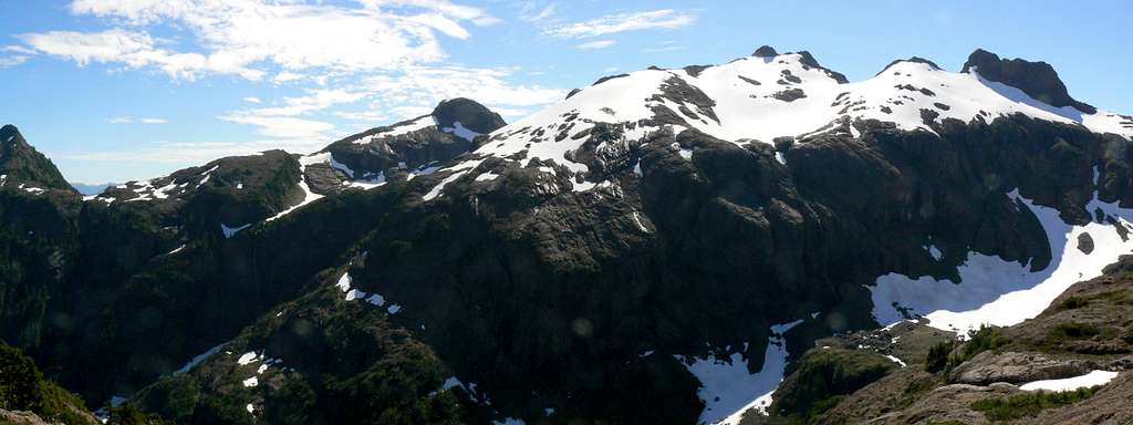
Mt McKelvie Northwest Aspect
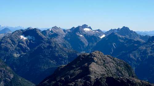
Mt McKelvie is an obscure and, until 2012, very infrequently climbed peak situated at the northern end of the Tlupana Range, on Vancouver Island. It is separated from the main range by the McIvor Creek valley and this may account for the lack of attention that it receives. The summit overlooks the west coast village of Tahsis approximately 8 km to the southwest and from its central location provides perhaps the best views of The Alava Bate Sanctuary, Rugged Mountain and the Haite Range in general.
Prior to 2012 McKelvie saw few if any ascents and what there were were multi-day affairs starting from Tahsis itself. In the summer of 2012 the Alpine Club of Canada, Vancouver Island Section, established a helicopter supplied camp at Nickel Lake in the McKelvie Basin to the north and proceeded to explore the surrounding peaks from there. The summit of McKelvie received a dozen or so visitors during the course of this camp.
In 2014 a route was pushed through from the McIvor Creek Valley to the east to the ridge system northeast of the summit that makes finally McKelvie an accessible and convenient objective.
Evidence of placer mining near the summit demonstrates that McKelvie was not always a neglected destination for those on foot, although the destroyed communications tower just below the summit was almost certainly serviced by helicopter.
There is no survey monument on the summit, nor does McKelvie host a visitor log book.
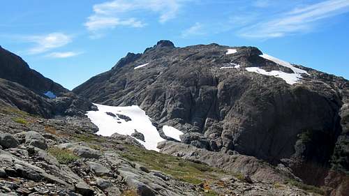
Mt McKelvie Northeast Aspect
Getting There
Vancouver Island can be reached directly by air from many destinations including Toronto, Vancouver, Seattle, Calgary, Edmonton and San Francisco to either Victoria, Nanaimo, Comox or Campbell River and by ferry from Port Angeles to Victoria on The Coho and on BC Ferries from Vancouver to Victoria or Nanaimo. Public transport on the Island is notoriously poor and anyone arriving by air would be advised to rent a car.Approaches to McKelvie generally require use of gravel roads but, with one exception, these can be negotiated with a normal sedan.
Approaches
Approach the mountain from the south on the Inland Island Highway 19 from Victoria or Nanaimo. Note that map references are on the NAD27 datum.Tahsis Approach
From Campbell River, at the end of the freeway section of the Island Highway, take highway 28 west towards Gold River. After approximately 30 km the road meets Upper Campbell Lake and after 47 km you will enter Strathcona Park at Elk Portal. Exactly 1 km further on highway 28 makes a right turn over the bridge at Buttle Narrows. Take this turn and drive to Gold River. From Gold River follow signs initially to Tahsis or Woss. Roughly 2-3 km from town cross the Gold River and immediately take the left hand road which reaches Tahsis in about 60 km. The road is mostly gravel with some paved sections.
McIvor Creek Approach
Approach via Gold River as described above but turn right after crossing the Gold River and follow the Nimpkish Valley Road in the direction of Woss. Pavement ends after 1 km or so and all roads from this point are gravel. Drive ~36 km up the Nimpkish Valley and find Vernon Lake Road heading west.
Alternatively, drive Highway 19 north of Campbell River. Pass through Sayward Junction and 11 km before the turn-off for Woss, turn left at the sign for Schoen Lake Provincial Park. All roads from this point are gravel. Almost immediately after turning onto gravel the road forks. Take the right branch signed for Gold River. This is the north part of the Nimpkish Valley Road. Drive 27 km from Highway 19 – following signs for Gold River if in doubt - and find Vernon Lake road on the right.
The road is called Vernon Lake Road at first and then becomes Sebalhall Road after it passes the branch road to Vernon Lake. At 4.3 km from the Nimpkish be sure to keep right at a junction at 9 U 686095 5542158 where Upper Sebalhall Road heads left. Continue west from this point around the head of Vernon Lake (with a brief view of the lake) and into the McIvor Creek Valley. 18.5 Km from the Nimpkish find a steep spur on the right just before a C-Span bridge. A normal 2WD sedan could probably make it this far but progress up the spur requires 4WD with high clearance. Since it’s only 500m to the end of the spur, the last bit can be easily walked if necessary. Assuming you have the right vehicle, drive up the spur to the point where it has been blocked by a log and large ditch. Good camping here.
You are now at the entrance to a narrow valley with the route directly in front of you to the northwest.
Summit Routes
From Tahsis Direct
From Tahsis via Nickel Lake
E & B Helicopters will charter a flight into Nickel Lake from Tahsis on request. The short flight in up the canyon to the lake will demonstrate that this is not an approach you’d attempt on foot.
When the river is dry or low, a camp can be established on gravel bars a couple of hundred metres or so upstream from the beach which is the only feasible spot for a helicopter to land. If you are considering this approach PLEASE be aware that is an absolutely pristine place in which no-trace camping is paramount. Dispose of waste scrupulously or better still, fly it out with you.
From the gravel bar camp hike 300 metres SW to the south shore of the lake where the bluffs meet the water. Find the most feasible access point to the steep slabs above. The obvious greasy gully goes for some but most would choose to wade the lake to a less steep access point about 30 metres away.
 Access from Nickel Lake |  McKelvie Basin Access Slabs |  Nickel Lake |  McKelvie Basin Access Ridge |  North Access Ridge |
FRA: several members of the ACC VI 2012 summer camp expedition to the McKelvie Basin, July 2012.
From McIvor Creek
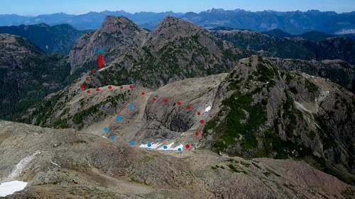
Go around the big log across the ditch and walk the disused/debuilt road for 1.4 km to its end. Turn left off the road end and cross the remains of the logging into the forest. Head NW at first staying on the left bank (true right) of the main river. Particularly in early season, the stream is heavily braided and many branches have to be crossed and re-crossed. Deadfall is the main issue at first and transitions into B3/4 Devil’s Club and slide alder as you get higher. Nevertheless, there are several open forest and two gravel draw sections and often good elk trail to follow. The route it also partially flagged. A distinctive “gorilla tree” about one third of the route up to the sub alpine confirms you are on the right line.
After the second of the gravel sections the route makes a hard right turn through some tangled krumholtz, climbs through dense slide alder – although on good elk trail – and continues north across a bowl before emerging into open elk meadows. Cross the meadows and continue on elk trail to the river.
 Lower Valley Bush |  Gorilla Tree |  McIvor Creek Approach Valley |  Approach Valley |  Route to Upper Bowl |
 Upper Bowl |  Summit Approach |  Approaching the Summit Block |  Final Scree Field |  Wrecked Communications Tower |
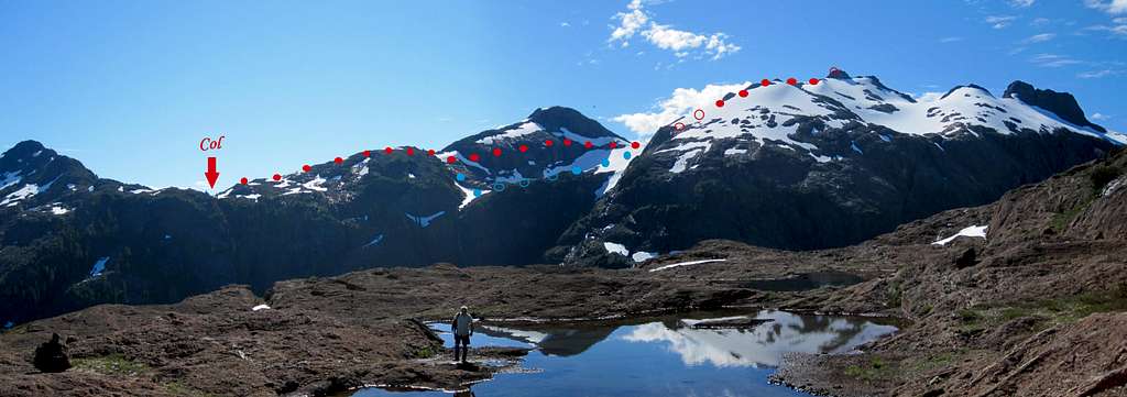
Summit Route from West
From the col make an ascending traverse towards the summit via the NE ridge of the 1,524 m unnamed peak that lies between. Eventually a brief descent is required to a tarn. At this point decide whether conditions merit dropping down to the snow or continuing with a high level traverse across the face of 1524 with the aim of reaching the col between 1524 and McKelvie.
Summit Route from Summit
From the col climb easy ramps SW to the summit block before the final tedious scree field to the summit.
Approximate route data
Total return distance: ~ 16 km
Net elevation: ~ 1,000 metres
Total elevation: ~ 1,200 metres
Ascent Time: ~ 7-8 hours
Descent Time: ~ 6-7 hours
FRA: Martin Smith and Tony Vaughn, September 2014
As always a MapSource/Garmin tracklog is available for the asking for the approach and summit routes. Just send me an email or PM.
 Summit View South - The Alava Bate Sanctuary | 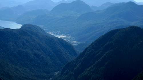 Summit View West - The Village of Tahsis | 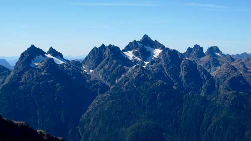 Summit View North - The Haite Range |
Red Tape/Safety Considerations
Absolutely no red tape.There’s nothing resembling a formal trailhead and an intentions system simply doesn’t exist in this neck of the woods. Make sure, therefore, that you have left a detailed trip plan with someone responsible. The RCMP and the appropriate SAR agency will respond in an emergency but it is up to you to have the mechanism in place that will initiate the call-out process if it becomes necessary.
This is a very remote location. There is no cellular service anywhere after leaving Campbell River.
Camping
Excellent camping at Nickel Lake as described.Likewise good car camping at the end of the McIvor Valley spur. Light no fires and, since giardia is well documented on the Island and since you’ve brought a vehicle this far, include a barrel of water in your supplies.
The upper bowl on the summit route would be a wonderful place to camp but this presupposes that you’ve lugged a full pack up through all that bush. I wouldn’t do it.
Useful Links
For more information refer to Island Alpine – A Guide to The Mountains of Strathcona Park and Vancouver Island, Philip Stone, Wild Isle Publications, 2003, ISBN 0-9680766-5-3For general backroad information and directions get hold of a copy of Vancouver Island Backroads Mapbook
Weather
Nearest point forecasts:West
East
Dedication
This page is dedicated to the memory of Island climbing legend Rick Eppler who left us just a few months after beginning exploration of the route from McIvor Creek. In the end you couldn't be with us on the summit Rick - except in spirit.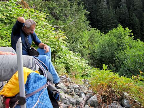 Rick Eppler on McKelvie | 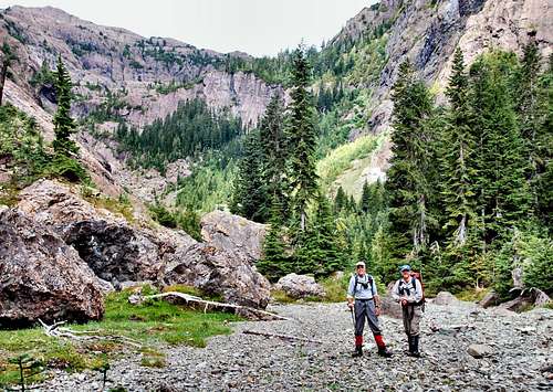 The Hanging Valley |