
-
 25435 Hits
-
 86.31% Score
-
 22 Votes
|
|
Mountain/Rock |
|---|---|
|
|
49.54437°N / 125.60617°W |
|
|
Hiking, Mountaineering, Skiing |
|
|
Spring, Summer, Fall, Winter |
|
|
5938 ft / 1810 m |
|
|
Overview
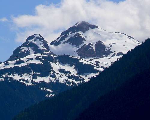 Mt Myra from Karst Creek Mt Myra from Karst Creek |
A rather unique aspect of Strathcona, and a not exactly welcome one, is the uses that outside for-profit interests are allowed to pursue in what should be a protected wilderness area. Over the years various nefarious deals involving business and government have seen swaps of land for mining and timber rights inside the park. To this have been added recent proposals that would allow “wilderness lodges” inside this and other parks in BC.

Westmin Mine. Exactly what is this doing in a provincial park?

Mt Myra from Ralph River
In spite of these disadvantages, Myra is a popular and worthwhile day hiking objective in the summer and almost as popular in winter and spring with skiers. With just under 1500m of ascent (and descent) to reckon with and a real knee cruncher of a trail, it’s also a good workout. For this reason, many people like to camp at Tennant Lake and complete the trip over two days. The summit offers views of the south and east aspects of the park and also north up practically the whole length of Buttle Lake.
Mount Myra is named for Myra Ellison, daughter of Price Ellison, both of them members of the 1910 BC Government sponsored expedition to the interior of Vancouver Island. The success of this expedition, especially the first ascent of Crown Mountain, led to the establishment one year later of Strathcona Provincial Park, the first such park in Canada.
Getting There
Vancouver Island can be reached by air from Vancouver to Victoria, Nanaimo or Campbell River and by ferry from Port Angeles to Victoria on The Coho and on BC Ferries from Vancouver to Victoria or Nanaimo. Public transport on the Island is notoriously poor and anyone arriving by air would be advised to rent a car.Access in this case is all on paved roads and, therefore, fine with a normal sedan.
From Campbell River, at the end of the freeway section of the Inland Island Highway 19, take highway 28 west towards Gold River. After approximately 30km the road meets Upper Campbell Lake with the first views over the mountains and after 47km you will enter Strathcona Park at Elk Portal. Stop and admire the large wooden elk statue. Exactly 1km further on highway 28 makes a right turn over the bridge at Buttle Narrows. Ignore the turn and carry straight on down the paved Buttle Lake Parkway (also known as Westmin Mine Road). This runs south down the east shore the whole length of the lake and offers ever improving views. Mount Myra can be seen looming over the end of the lake just after passing the Ralph River campground. About 39km south of the Buttle Narrows bridge, the road swings west over a bridge around the end of the lake. Pass the gravelled Jim Mitchell Lake Rd on the left, drive 6km up the hill, through the mine site and into the BC Parks parking lot on the far (west) side of the mine
The Route
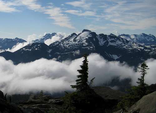
Mt Myra N Aspect from Phillips Ridge

Myra from Tennant Lake

Sandbag Lake

Summit view N down Buttle Lake

Summit view S to Mt Septimus
The initial part of the route is the remains of an old bulldozer road used when Westmin built its dam at Tennant Lake. It makes no more than 4 or 5 contours as it heads unrelentingly up the hillside to the lake. Although improved in recent years, the way is steep and broken, particularly the higher you get. This part of the hike is a bit of a burden on tired knees when heading down at the end of the day. After approximately one hour, the route breaks out of the trees into an open area where the pipeline running down from the dam crosses the confluence of Tennant and East Tennant Creeks. This makes a good spot for a break.
Cross Tennant Creek (the old bridge built right on the pipeline no longer exists) and carry on up the penstock for a further hour of rough going to Tennant Lake. The large concrete dam and its boulder retaining wall bar access to the lake. Climb this barrier with care and finally reach the lake.
From the north end of Tennant Lake and quite close to the dam, pick up flagging that takes you SE and up to a flat rocky area below Myra’s west face. Cross the flats and carry on up a steep, wet gully where a fixed hand line is usually in place. Immediately after climbing the gully, trend leftward, but still SE, and climb up to (unofficially named) Sandbag Lake at GR 098904. This is a lovely alpine tarn right under Myra’s SW ridge and an ideal spot for lunch – about 4 hours from the start. Sandbag Lake is great for a swim on the way down but beware that it’s VERY cold.
From the north end of Sandbag Lake – the end you arrived at – pick up cairns that take you round to the east side of the lake and up onto Myra’s broad SW ridge. Walk up the ridge passing a false summit on its south (right) side and down into a col below the summit dome. Across the col a steep, vegetated and somewhat exposed gully offers Class 3 climbing straight up to the summit.
If the weather is clear you’re looking east across the Price Creek drainage to Flower Ridge and Central Crags and beyond to Mts Harmston, Argus and the Red Pillar in the SE sector of the park. To the south and west from left to right is the Septimus/Rousseau massif, Big Interior Mountain and Mt Tom Taylor. The ribbon of Buttle Lake runs north with Mt Albert Edward and Augerpoint prominent
Descend the way you came up. The round trip takes 10-12 hours car to car.
Red Tape
None. You are outside the designated core area of Strathcona Park.Be aware that BC Parks does not operate an intentions system. Make sure, therefore, that you have left a detailed trip plan with someone responsible. Parks and the appropriate SAR agency will respond in an emergency but it is up to you to have the mechanism in place that will initiate the call-out process if it becomes necessary.
Camping

Tennant Lake Dam with helicopter in situ
Many parties make a two day trip out of an ascent of Myra with a camp at Tennant Lake. This is not a maintained campsite and there are no facilities. Camp on already cleared spots and try to make as little impact as possible. DON’T use the one wooden platform that you will find overlooking the lake. This is for the helicopter that delivers mine personnel for maintenance work on the dam. I was there on one occasion when someone used this platform for their tent and forced the helicopter to land right on the dam wall (see photo). Rarely have I heard profanity at the level that this produced!
Fires are strictly prohibited, so you must pack a stove. Bear and cougar frequent the mountains and forests of Vancouver Island, so proper back country methods – hanging food bags out of reach, cleaning up all cooking scraps, good toilet practice etc – are essential. Giardia is well documented throughout Strathcona Park, so boil or treat all water.
External Links
Strathcona Provincial ParkNearest point weather forecast
Additional Information
The correct map for this trip is the government topographical map sheet 92 F/12, “Buttle Lake”. Advance copies can be ordered on-line at this link. Copies are usually readily available in good bookstores and outdoor stores throughout the Island.Suggested Reading
Beyond Nootka – A Historical Perspective of Vancouver Island Mountains, Lindsay Elms, Misthorn Press, 1996, ISBN 0-919537-29-4 and/or visit Beyond Nootka
Island Alpine – A Guide to The Mountains of Strathcona Park and Vancouver Island, Philip Stone, Wild Isle Publications, 2003, ISBN 0-9680766-5-3 and/or visit Island Alpine Climbing Guide