Third in three days but a nice hike nonetheless
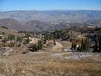
![Mt. Ogden]() Mt.Ogden from Snowbasin ski slope
Mt.Ogden from Snowbasin ski slope
Utah is an amazing state, it has just about everything you could look for, from high lofty peaks to desert canyons in red rock country. One of the pursuits I am involved in is chasing down the prominence peaks of the state and I was trying to make a dent this weekend. On friday, I had driven out into the Utah desert to nab
Keg Mountain, a pretty lonesome place in some pretty lonesome country. Then on saturday, I was back after one called
Champlin Peak, highest peak in the Gilson mountain range, not far from a place called "Little Sahara" Both of these peaks belong to the
Utah prominence group and I really felt the need to get off the desert peaks a bit and visit something a bit more alpine. Studying the map, I decided that Mount Ogden would be the perfect choice.
Mount Ogden is a beauty, visible for miles from I-15 and often it wears a mantle of snow which is why the east side has a ski area, an area that was utilized nicely in the 2002 Winter Olympics when they were held in the state of Utah. Snowbasin ski area hosted the downhill events and Mt. Ogden was the backdrop. I decided it was time to visit the area (without skiis) and so I headed up that direction from where I was staying in Orem Utah.
![Moose captured in bronze]() Moose at Ski lodge area
Moose at Ski lodge area
Driving up in the early morning, I found my way to the
ski lodge parking area and the lifts. A sprinkling of snow was present in areas where shadows dominated
yet for this time in November, it was strange not to see more of the white stuff. I could see some roads and a trail snaking up past the ski lodge but using my GPS to draw a bead on the peak, I just started up under the lifts.
I imediately regretted this as it was rather brushy but within 500 vertical feet, the brush became less dense and easy to walk through. I had no map of the ski area but soon I was able to find a road that was heading in the right direction so I shifted from going cross country up the slopes to staying with the road as it worked its way up. Just after getting on the road which was perhaps half way up, I met two men and their two dogs who were descending the road and confirmed that it went all the way to the saddle below the peak. They were doing a traverse having started early in morning from the Ogden side of the mountain. They had a ride waiting for them in the ski base area below. Now that sounds like the way to do this mountain. They mentioned I'd have snow in areas but nothing that would present a problem, which I found to be true.
![Under the lifts]()
I was just happy to be out and hiking upward. Now that I was on the road, I started making pretty rapid progress although switchbacks added to the overall distance as compared to just heading straight up the slopes. Still, what a great feeling it is to be outdoors in the brisk air and feeling the wind push at you as you expend effort. On a mountain like this, it is somewhat lame to be hiking a ski area and yet the fact that most people would ride a chair lift up to the top of the lift areas and then ski down, made me feel better about what I was doing. In another month or so, the ski lifts of Snowbasin would probably be operating and people would be doing just that. Riding up and skiing down. I would then don my snowshoes
to do this same mountain although I am a skier and would enjoy skiing the runs.
Off to the sides I could see the snow making guns, all poised and waiting for the temps to drop enough so that any snow made would stick. The temperature as I was hiking down later was in the mid 40's, not quite cold
enough for the snow making process to begin.
Finally the "road" left the last lift line and headed up towards the saddle. There was snow along the road at this point but it was easy enough
to just walk along the edge where the snow had melted and a track was easily followed. Upon achieving the saddle, I had a "wow" moment as suddenly, surburbia (Ogden) was now visible and spread out before me.
The road up to the peak was truly ugly as it was free of snow and a rather loose rocky affair. I made my way up it and past a path which had a sign stating "trail". I continued up the road to where it switchbacked up to the building and I was glad I did. Sidestepping a small snow section, I found that next to the building was a very steep side of the hillside which had the rocks cemented into place so that no erosion would take place by people like me who would scramble up it towards the top.
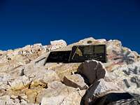
After a little climb of about 20 feet, I looked up to see two plaques and
a benchmark just above me. The benchmark was a witness marker but it was badly scarred, so much so that I couldn't read the inscription on it. The
two plaques had also received some abuse but both were still legible. Climbing a few more feet up put me on top of the flat summit where the
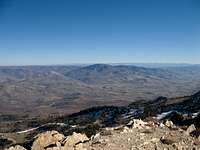
main benchmark was located. It was inscribed as "Ogden Peak 2" so that must mean that there is an "Ogden Peak 1" somewhere. A few rocks just a bit from the benchmark were the actual highest spot of ground on the mountain so I sidled over and checked them out. The thing I really liked were the views I had, with the one exception of where the tower structure impeded it on the Ogden City side. The views north, east and south were quite nice.
I noted a helipad on the top area as well and after grabbing a snack, taking some pics, I followed a cement stairway down a few feet before separating myself from it and working back down to where the hiker path was. The hike back down went uneventfully and I knew that someday I would have to return and hike this mountain from the Ogden City side, that would make this one feel better.
The total hike was 7 1/2 miles roundtrip and I had an elevation gain of close to 3200 feet.
Two days later, I closed out my flurry of peak bagging by getting
Black Crook Peak LINK TEXT HEREout in the Utah desert.
A route?
I hesitate to post a route for this side of Mt. Ogden simply because this is
a hike you could do up roads from the ski area. I chose to do as much of it
cross country as I could but finally in order to gain the ridge, I ended up taking the road about half way up. On the way down, I actually got off the road again about half way down and walked down the ski slopes again but via
a slightly different way. I rectified the situation by hiking up
Black Crook Peak two days later by using totally a cross country route.
Still, this is a nice hike, one that most people could do even if not in
very good condition. The key problem for most people might be the elevation
if coming from sea level and doing this on a very hot summer day. Perhaps the best way to enjoy Mt. Ogden would be to do the traverse, coming up from the Ogden side and hiking down through the ski area side. Having transportation
on both ends would be the key requirement.
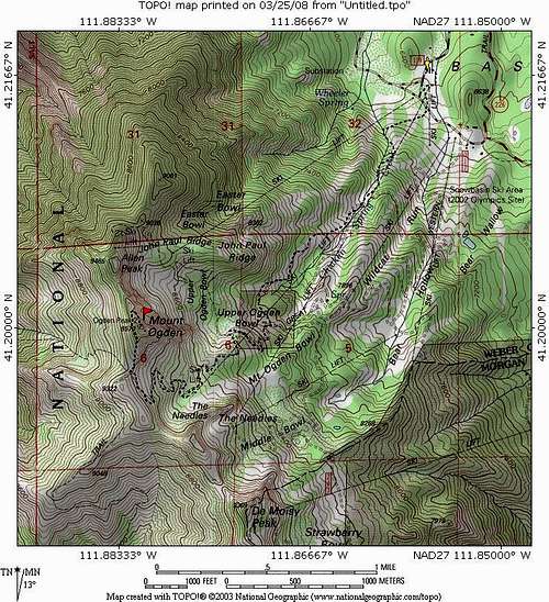
Again, my map will give you a fair idea of how I went up and down but you are able to take trails and the roads as you see fit if you should decide to hike the peak from the Snowbasin side.
Views


Comments
Post a Comment