
|
|
Custom Object |
|---|---|
|
|
46.42280°N / 86.6214°W |
Overview
** DISCLAMER: information on this page is by no means complete. I would greatly appreciate it if people with additonal or more up-to-date knowledge of the area/routes/etc leave their corrections and comments, so I could incorporate them in this resource. Thanks in advance. **Great winter ice climbing in the Midwest. There is an ice fest held every winter too (usually beginning of February).
SEE EXAMPLES HERE:
1. (my photo-report on 2005 MI Ice Fest)
2. Additional info at www.downwindsports.com
and MI Ice Fest 2005
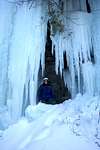
3. Example climbs: The Curtains (multiple), Dryer Hose...
4. Also: Grand Island has ice routes over 200 ft high.
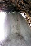
check out Grand Island ice caves here:
Grand Island ice caves
5. See how the Dryer Hose route is undergoing a liquid-solid phase transition:
Dryer Hose yearly cycle
6. Also more info at
http://www.climbingcentral.com/
7. Grand Island Ice climbs:
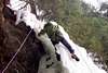
Grand Island is a recreation area that is approximately seven miles long, four miles wide and has a 27-mile perimeter. Three sandy beaches and dramatic 300-foot sandstone cliffs rim the island. It is these sandstone cliffs that form the base for some incredible ice formations. It lies just off the shore from Munising and can be quite a tease to ice climbers as it’s shores are inaccessible until the ice forms on the bay and in the channel.The east shore of Grand Island can be seen from the Sand Point Road parking area, which produces incredible ice formations that drop to the shore ice. Most of the climbs on the east shore are lead climbs only as setting top ropes is nearly impossible. Trout Bay is an ice climbers paradise! The western shore of the bay develops into huge sheets of ice ranging in height from 20 to 90 feet high. Skiing or snowmobiling to the island is popular way to access the climbs.
Warning: Check with locals or the Ranger station in Munising before venturing out on the ice.For local ice conditions visit
www.downwindsports.com
 |  |  |  |
Getting There
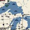
To MUNISING:From Lower Michigan: Take I-75 North across the Mackinac Bridge into the Upper Peninsula. Take US 2 West. Turn right on 177. Turn left on 28 and continue to Munising.
From Wisconsin: Take 41 North. Turn right on 94. To access Rock River Canyon Wilderness Area, turn left on Rock River Road in Chatham. For Munising and Grand Island, continue on 94 to 28. Turn left to enter the City of Munising.
To MARQUETTE:
From Lower Michigan: Take I-75 North across the Mackinac Bridge into the Upper Peninsula. Take US 2 West. Turn right on 177. Turn left on 28 and continue through Munising. Marquette is 44 miles west of Munising.
From Wisconsin: Take 41 North until you reach the City of Marquette.
In Munising, go to Sydneys restaurant (hard to miss in Munising) and ask locals or visiting ice climbers of ice conditions and areas to go to.
 |  |  |  |  |
Rules and regulations
Over the years, ice climbers have developed a great relationship with the park service in regards to ice climbing within Pictured Rocks National Lakeshore. The park service has even developed their own ice climbing brochure available at the visitor’s center in Munising. The park service has set forth the following rules and regulations to help preserve this beautiful lakeshore.Do not park along Sand Point Road. Please park in the designated parking lot at the end of Sand Point Road.
Pets are not allowed at any of the climbing areas. If you have any questions regarding these rules or regulations, please don’t hesitate to call the park service visitor center at 906-387-3700.
When To Climb
ICE CLIMBING: December - March (locals say you could sometimes get on ice by Thanksgiving)ROCK CLIMBING: sandstone in Munising is very fragile, and park rangers don't like people rock- and especialy mixed- climb there. For rock-climbing, go to nearby Pictured Rocks area:
The Upper Peninsula of Michigan can be characterized as a sparsley populated region with prodominatley northern hardwood forsest. Hidden within these forests quartz, basalt and granite bluffs immerge offering hundreds of routes for climbers to work. Forty miles north of Marquette is a ripe area that see's little or no action throughout the year. This is one of the few areas that has cliff side camping. From slabs to overhangs this area has it all. Take CR 550 north out of Marquette towards Big Bay. Turn left on CR 510. Travel several miles and turn right on the AAA road. (The first main road you will come to). Go 2 miles and turn right on a two track. Follow it to where the road splits, turn left and go 20 yards. The crag is on the right. Area Classics: Nasal Drip, Carbo Boy Topo Negaunee NW.
Camping
1. Winter camping within Pictured Rocks National Lakeshore is available only in the designated lakeshore backcountry sites and a permit is required. Overnight camping in parking lots is not permitted.2. You can stay in motels in Munising (cheap)
Mountain/Route/Ice Conditions
www.downwindsports.comCall Down Wind Sports at 906-226-7112
Miscellaneous Info
ROCK CLIMBING in the area: Pictured Rocks area. See more info at www.downwindsports.comExternal Links
- Down Wind Sports page
Munising ice fest organizer
- Grand Island ice caves
Grand Island ice caves
- Climbing Central: Munising Ice Climbs
Numerous routes/descriptions in the Munising area.