
|
|
Area/Range |
|---|---|
|
|
42.85999°N / 0.15553°E |
|
|
Hiking, Mountaineering, Trad Climbing, Sport Climbing, Ice Climbing, Aid Climbing, Big Wall, Mixed, Scrambling, Skiing |
|
|
Spring, Summer, Fall, Winter |
|
|
10472 ft / 3192 m |
|
|
Note
 Dawn lights on the Pic Long
This page, like Gavarnie and Vignemale, is another secondary area of the Bigorre.
There is so much to write about it, that I thought such a page would be better than overloading the Bigorre.
I would like to thank the following people for their stunning photos of the sector, which I abundantly used here: Rafa , Franganillo, and Edouet.
This page is dedicated to Jean-Marc Bergeron, a great mountaineer from my former town Agen and its mountaineering club, who sadly left us in the end of 2010. He died far from the mountains but the Néouvielle scrambles always were close to his heart.
Overview
 Sunset upon Néouvielle
 Sunset upon Néouvielle
 Lake Loustallat, old photo
 Lake Loustallat, old photo
 Aumar & Néouvielle
 Gourg de Rabas
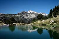 Lac Inf. de Bastan
 Barèges valley from Néouvielle
"The granitic region of the Néouvielle is remarkable by its amount of lakes, the beauty of its landscapes and forests.
It is one of the rare regions of the French hillside of the Pyrenees that evoke the very special charm of Spanish granitic valleys. The abundance and limpidity of the waters, the black scarps crowned with dwarf pines, lawns framed by bosks and crossed by adorable streams, the dark blue lakes, or green, whose banks are filled with rhododendrons, or decorated with even finer colours of flowers, make this region a paradise for walkers, painters, botanists, photographers, fishermen and, of course, mountaineers."
(Sample of the Ollivier guidebook, edition of 1937)
Robert Ollivier perhaps did not expect his words to be so accurate, when comparing the Néouvielle to Spain. It was in the meantime scientifically proved that due to the layout of this mountainous area, oriented as a gradual slope looking south to the sun, it enjoys a specific microclimate. Combined to the fact that the french northern mountainside gets more rain from the Atlantic, gathered the conditions to make it the botanical garden we see.
The variety of fauna and flora is unique: 370 animal species have been identified, such as the capercaillie, the crossbill, the gray partridge, marmots, chamois. Lakes and streams are the home few endemic species such as the Desman, small aquatic mammal also known as the Trumpet Rat. 571 different species of algae have also been identified. Even toads have been observed in the highest regions, and, as for flora, there is no other place in Europe where trees grow so high: the though "black pine" can be seen as high as 2600m !
Pic de Néouvielle comes from the old Occitan "Nèu Vielha", which means "old snows". The beauty of the landscape, so full of lakes, and omnipresent water, owes everything to the granitic nature of the terrain. Granite, unlike sedimentary stones, does not erode. Consequently, during the withdrawal of the glaciers, many stones accumulated as dams to form moraines, or when covering pockets of ice, formed depressions as it melted. The abundance of granite can be explained by the fact that the main ridge of the Pyrenees, in the Bigorre, does not correspond to the granitic horst, the "geologic main ridge". The Gavarnie-Perdido range, standing on the border and made of limestone, despite forming the water divide, is only on outstanding sedimentary fold. Specificity shared by the Ardiden area (its continuity, only cut by the Gavarnie valley), aside the Vignemale. Such asymmetry is partly explained by the important dip (geologic inclination), as well as the fact ice erosion was more active on the colder northern side. Further, granite converges again to the main ridge, at the Balaïtous more west, and the High Luchonnais via the Montious more east.
Counting the number of lakes in the Néouvielle could be summarized as a Chinese puzzle, or in one question: "from when a piece of water is a lake"... Despite few huge developments made by men, most of them dams, this richness was not too altered, and the hiker will be embarrassed with choices. For this reason, the Néouvielle is sometimes flatteringly designated as the "French Aigüestortes", for its similarities with the famous Spanish original.
The "Réserve Naturelle du Néouvielle", adjacent to the National Park of the French Pyrenees (and often confused as being a part of it), was created as soon as 1935, much earlier than the Park in 1967. It covers 2313 hectares and aims to protect the biodiversity of the area.
The Natural reserve covers in fact a bit less than what is usually meant by the term "Le Néouvielle", the south part (Barada & Cap de Long) being a part of the National Park.
The Néouvielle region, as we could call it then, can be divided in eight valleys, a bit like a big oval Camembert oriented from SW to NE. Each of them has a specific character, provide different hiking goals (peaks or anything else) and will be described below.
Getting There
 Lac d'Orédon
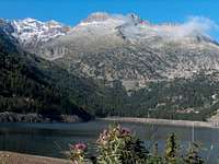 Lac d'Aubert
 The Ramougn
 Hourquette d'Aubert
 Lacs d'Estelat
 Coume Estrète
 Lac d'Orédon
 Lac d'Aubert
By public transports
Due to its touristic popularity and ski resorts, the Néouvielle is quite accessible for the non-motorized hikers, in comparison with other French areas of Pyrenees.
Saint-Lary is served by the regular SNCF buses, via Lannemezan, on the Pau-Toulouse line. All timetables can be checked on the SNCF website : www.voyages-sncf.com. The Aure valley used to be served by train as well, until Arreau, but this line is currently used only for industrial purposes. There were talks about reopening it for passengers, but no one knows.
Once in Saint-Lary, there are several ways to penetrate the massif without the help of a private car :
- The travel company Costa Voyages regularly operates shuttles to the Orédon, Cap de Long, Aumar and Aubert lakes ("route des lacs") during the high season. Contact them for more information, or ask/phone the Saint Lary touristic information ("Maison du Parc National").
- The cable-car of Saint-Lary leading to the Pla-d'Adet ski resort works in summer. Pla-d'Adet is not a very convenient place to reach the heart of the mountain, but it saves a significant elevation if one plans a several-days hike. The area of the Lacs de Bastan is reached via the ridge of Hèche Barrade, (exposed and unstable, album here).
- The ski-resort of La Mongie (Tourmalet pass) is served by the SNCF buses, and there is a direct connection from Tarbes. Other alternative ways of transportation can be found here (winter season) and here (private shuttles, irregular schoedules, contact them by phone). The valleys of Ets Coubous, La Glère, and Campana de Cloutou are then well reached.
- Since Gavarnie is served also by the SNCF buses, Gèdre and Pragnères below have their stops too. Vallée du Barrada is then served too.
 Spain by car
All trailheads in the Aure valley are quickly reached from Spain thanks to the tunnel of Bielsa.
In order to reach the others, we need to circumvent the whole massif anticlockwise: Campana du Cloutou, Ets Coubous, La Glère or Barrada : the furthest the longest. Driving down until Arreau to catch the road of Col d'Aspin is not needed: another secondary mountain pass connects to it, and avoids a significant drive: take the road to the Hourquette d'Ancizan in the homonym village. The other end reaches directly Payolle. The drive is very scenerical and you will enjoy it. Then, the next pass, Tourmalet, is reached via Sainte-Marie-de-Campan. A last drive up in the diction of Gavarnie is needed for those seeking Barrada.
 France by car
Thanks to the A64 (E-80) Motorway that goes very close along the Pyrenees on its section between Saint Gaudens and Lannemezan, the access to the Néouvielle is made very quickly. One can leave the A64 in Tarbes, Tournay or Lannemezan to reach either the Gavarnie, Campan and Aure valleys.
The map below shows the position of trailheads mentioned in each subregion :
- I : Dam of Cap de Long (Vallée de Cap de Long)
- H : Dam of Lac d'Aubert (Aumar, Aubert, Orédon)
- G : Dam of Lac de l'Oule (Vallon d'Estibère)
- F : Col de Portet (Lacs de Bastan)
- E : Artigues trailhead (Vallée du Campana de Cloutou)
- D : Barèges trailhead (Vallée d'Ets Coubous)
- C : Betpouey village (Vallée de la Glère)
- B : Pragnères power plant (Vallée du Barrada)
View Larger Map
Valleys & Subregions
View Néouvielle in a larger map
Cap-de-Long, Orédon
 Lake Loustallat, old photo
 Lake Loustallat, old photo
 Cap-de-Long
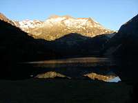 Lac d'Orédon
 Balcons de Cap de Long
 Balcons de Cap de Long
 Lac d'Orédon
 Orédon from Estaragne
The valley constitued of these two famous artificial lakes is undoubtely the one that men transformed the most.
The Orédon lake, already existing in a natural state, was enhanced as early as 1882 to elevate artificially its level. It was the first dam built for industrial purposes in the Pyrenees, and one of the first in Europe. Russell, aware of these works, declared, bitter :
"Everyone heard of these interesting works over the Orédon lake, which the state is carryong out at great expense, which is meant to raise of scary number of meters the water level so that the Aure valley doesn't lack water. A dam will fullfil this goal, although spoiling the landscape, and perhaps collapse after some storm, flowing few villages in the valley. This sadly grave and costy .... But science wants the useful at any cost."
If he knew this was only the premise of the titanesque Cap de Long dam in 1945, he would have had perhaps a heart attack...
"Cap de Long" was known formerly as a valley with a myriad of smaller lakes known as "Laquettes de Cap de Long", the largest on them forming the Lake of Loustallat. The scale of this construction was, at this time, a real technological challenge, meant to be a showcase of the French expertise, somehow comparable to Viaduc de Millau nowadays. This good website relates it well.
Today, despite the way they radically changed the aspect of this valley, Orédon and Cap de Long are still impressive to watch. The fittings on Orédon are nowadays very discrete, making it looking almost like a natural lake with grassy shores, in which is reflecting the peak of Hèche-Castet, often mistaken with Pic de Néouvielle.
Cap de Long, on his side, looks like a dark blue long fjord. The wind that rushes into it, raising waves, make it look kind of scary and gloomy. But, for this precise reason, it drains crowds of visitors that come just for this only sight.
The road of the Couplan valley leads to both lakes. At the first is located the Refuge Hôtel du Lac d'Orédon. "Refuge" as it serves well as a mountain-hut, "Hotel" because served by a road. Cap de Long, 2160m, is reached after an impressive set of laces which make a popular cycling goal. Some refreshments stand in the high season near the trailhead heading to some three-thousanders like Pic Long, highest and hardest peak of the Néouvielle area, his lieutenants Badet Maubic and Maou, or the Campbieil -Estaragne duet (not always considered as part of the Néouvielle since out of the granitic terrain).
The historic trail used to go in what is now a cold ocean, and nowadays's approach is made via a trail along its south shore. In order to circumvent a small escarpment on the shore, significant ascent and descent are made in the only approach, and exhausted hikers often joke about the signification of the lake's name, being "Long" not only by coincidence :)
Another trail of this valley is worth mention: the "Balconies of Cap de Long", over the opposite north shore. As it name suggests, this is a breathtaking path going over a tiny stripe of grassy slope, under and over cliffs whose exposure is straight over the lake. It links the Breach of Hèche-Castet, also called "Pas du Gat", coming from Lac d'Aubert (next valley below), to Col Tourrat, passageway to the Barrada valley. From which we can also catch back the trail to Pic Long.
 Sunrise in Cap-de-Long
Aumar, Aubert, Laquettes
 Lac d'Aumar
 Lac d'Aumar
 Lac d'Aubert
 Trail...
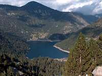 Lac d'Orédon
 Pic de Néouvielle
These sites are served by a road as well, built in 1972 despite the classification as a reserve in 1968. Which explains the high popularity (sometimes excessive ?) of this place. In order to remedy to this problem, the portion of road from Orédon to Aubert was featured with a toll in 1994, during the high season.
But this restriction is not as unlucky as it seems like. Between the trailhead of Orédon, convergence of the two valleys, and Aubert, is located a beautiful piece of trail going along a set of little emerald lakes, named "Les Laquettes", nestled in a fragile ecosystem of marshes. Usually spared with crowds, it is a must-see.
Further up, hikers can reach the Néouvielle by several ways, but not only. Some important passageways to neighbouring valleys, like the impressive Brèche de Chaussenque to the Vallée de la Glère, the Col d'Aumar to the Vallon d'Estibère, the Hourquette d'Aubert and the Col de Madamète to Vallée d'Ets Coubous, visiting the secret site of the Gourg de Rabas.
A set of interesting secondary peaks like Pic d'Estibère, Pic de Madamète, Pic d'Anglade, Soum de Montpelat, or the 2600m unnamed peaklet over Col d'Aubert make other hiking goals. As a descent to Orédon, it is adviseable to try the trail heading steadily over the lake till Cap d'Estoudou, another first-class viewpoint before hiking down.
Two very individualized peaks, which make most of the skyline from Lac d'Aumar, form the southernmost rampart of the area, over Aragnouet: Bugatet and Pic Méchant. As the last of the two suggests, they are not easy hikes despite under 3000, on wild and unstable terrain.
 Panorama on Les Laquettes
Vallon d'Estibère
 Lac du Cascaret
 Gourg de Rabas
 Primeval forest...
 Primeval forest...
The valley has five little lakes gradually disposed: Lac du Pé d'Estibère or Lac Cascaret, nestled in a marshy depression in the heart of the forest. Lac de l'Ours and Lac d'Anglade, in the upper limit of the forest. Lac de l'Ile, with a rocky island as the name tells, on which grows a grove of few pines. And Lac Supérieur, at the start of the alpine level.
All these lakes host a rich aquatic ecosystem, including the truit fario. Blueberries and alpine Soldanellas are found in abundance. And it is precisely here that can be observed the highest trees of Europe. The only "tour of the lakes" justifies well a round-trip.
The Estibère valley is reached either from Cap d'Estoudou, previously mentioned, or from the trail elevating left at the upper end of Lac de L'Oule, described in the section below.
Pic d'Estibère and Pic de Gourguet close the end of the valley, ridge behind which is located the Aygues-Cluses valley, easily accessible thanks to the generous grassy slopes. Col d'Aumar, left, links to the homonym lake, and Col de Gourguet, right, to the upper Port-Biehl valley.
This is a fine and quite safe hiking terrain in winter due to generous relief.
 Néouvielle view from Pic d'Estibère
Lacs de l'Oule & Bastan
 Lac de Port-Biehl
 Lacs de Bastan
 Lacs de Bastan
 Lac Inférieur
 Lac Du Milieu
 Lac Supérieur
 Pic de Bastan
 Lac Supérieur
At the base of it is located the largest artificial lake after Cap de Long, the Lac de l'Oule (built in 1922), whose dam is served by a road, and near which is located another "refuge-hôtel", the Chalet-refuge de l'Oule. Despite artificial, this large lake is not bad-looking, excepted when its level is abnormally low, revealing stratified sandy banks, like a scar.
As the upper end of this lake is reached, one can either step into the Vallon d'Estibère previously described, go straightforward until the magnificent and large Lac de Port-Biehl, or elevate on the right side to reach the not less famous site of the Lacs de Bastan.
While heading to Port-Biehl, we meet a large amount of smaller lakes, like the Laquet de Coste Oueillere (shelter), the Laquets de Port-Biehl, the Gourg Nère, or the Gourguet lake, its pass to Estibère.
Port-Biehl also designates a large grassy zone over Pic de Contadé, that gives simultaneously access to the valleys of Campana de Cloutou, Quatre Termes (out of the reserve), or Aygues-Cluses (by Col de Barèges or Hourquette Nère). Near the lake of Port-Biehl stands a metallic shelter often used by mountaineers. Houquette de Caderolles, a high pass, also gives access to the upper Campana de Cloutou valley.
The neighbouring Lacs de Bastan are more commonly reached via the road leading to Col de Portet, over the Espiaube ski domain, accessible via the Plat d'Adet road from Saint-Lary. The site consists in three lakes gradually settled: Lac Inférieur, du Milieu, and Supérieur. The second is also the largest one. On an cape of its complex shore is built the guarded hut whose location is the most romantic in the whole french Pyrenees: the Refuge de Bastan. Further up, the Col de Bastanet, high pass, gives access to the upper Campana de Cloutou valley, as well as the most magnificent peak of the area, Pic de Bastan, a must-see panorama at the cost of a little scramble.
Pic du Portarras, located opposite on the pass, offers an almost identical panorama, as well as the access to the Aulon valley, neighbouring the Arbizon. Col de Bastan, over the middle lake, provides a simplier access as well, near the rounded Pichaley, popular destination for ski-touring.
From the Lacs de Bastan, one can also reach directly the lakes of Port-Biehl, admiring on the way the emerald Lacs du Bastanet, thanks to a steady trail that avoids getting down to the level of Lac de l'Oule.
 Lacs de Bastan and hut
Lacs du Campana de Cloutou
 Artigues trailhead
 Lac du Campana
 Lac d'Arrédoun
 Lac d'Arrédoun
 Campana, Grézioles, Noir, Laquets
 Lac de la Hourquette
The northernmost valley of the Néouvielle area, and first in our anti-clockwise tour to be in the watershed of the Adour, is reached from the Campan valley and the road of the Col du Tourmalet, slightly before the ski resort of La Mongie (recently merged with Barèges to form "N'Py"). The trailhead is located at the end of a long sharp lace just over the village of Artigues.
Not less than eight beautiful lakes can be counted in the main part of this valley, to which we must add a countless amount of smaller tarns in the subvalleys of Cloutou (west) and Gréziolles (east).
As we elevate, we meet the Réservoir des Laquets, first of the two artificial lakes of the valley. Next to it is located a natural one, Lac de Caderolles, seen only while making a diversion.
The second dam, Lac de Gréziolles, rivalizes in size with Aubert or Orédon. It is followed by an homonym and natural smaller brother, Laquettes de Gréziolles.
From this point, one can choose to visit the amphitheater of Cloutou, making the separation with the Port-Biehl area, or the upper Gréziolles valley, where the Lac Noir, the Lacs de La Touyague and the Lac de l'I (shortest lake name in the Pyrenees !) are met under Col de la Couradette, linking the Gaoube valley and the Payolle resort.
Continuing further up, the next large lake, Lac du Campana is met, with the guarded mountain hut next to it. Another magnificent site.
Next, again, Lac d'Arrédoun is reached. It has a smaller brother kind of divided in two with few emerged stones, on which the trail goes by pure fantasy.
Finally, the Lac de la Hourquette, perfectly round, forms the end. Two high saddles previously mentionned provide an access to the Port-Biehl and Bastan areas: Hourquette de Caderolles and Col du Bastanet, possibly to the top of Pic de Bastan.
 Lac de la Hourquette
Ets Coubous & Aygues-Cluses
 Ets Coubous
 Aygues-Cluses
 Pic des Quatre Termes
 Lac Nère
 The Aygues Cluses valley
 Melting ice
After a vast separation from the previous valley, made by the complex and mountainous area of Quatre Termes (its largest valley, Coume de Porteilh, makes the ski domain of the resort of La Mongie), we reach the next important basin of the north side of the Néouvielle. It consists in two subvalleys linked together on their top, which make a fine round tour: Ets Coubous and Aygues-Cluses.
Similarly to the previous trailhead, this is a similar wide lace, on the west of the Tourmalet pass, in the Barèges valley, that makes the accès.
The largest lakes are seen in the western half, the Vallée d'Ets Coubous: Lac d'Ets Coubous, the only artificial, Lac Blanc, Lac de Tracens, Lac Nère, Lac Estagnol.
The twin peaklets of Pic de Tracens and Pic de la Touatère make a separation with the other half, Aygues-Cluses. Pic de Madamète, the main top of the area, is facing them, and can be climbed on the way. The Hourquette d'Aubert, west, and the Col de Madamète, east and via the lake Gourg de Rabas, link to the Aubert and Aumar lakes.
Col de la Mourèle and Hourquette de Mounicot, two passages close to each other, provide an accès to the valley of La Glère, below.
The tarns in the eastern half of Aygues Cluses are more numerous and smaller: Lacs de Madamète and Lacs d'Aygues-Cluses. Where we reach the thalweg is located a small unguarded hut, Cabane d'Aygues-Cluses, often described as dirty, but not less popular for hiking purposes thanks to its convenient location.
Then, we can either go back via the convergence of the two valleys, down, reach Estibère via the Col de Gourguet or to the upper Port-Biehl valley via Col de Barèges or Hourquette Nère.
 The valley of Aygues-Cluses
Vallée de la Glère
 Trailhead of La Glère
 Lake of La Glère
 Néouvielle from La Glère
 Vallon de La Glère
 Lac Bleu
 Lac Bleu
This lacustrine unit is indeed divided by two very distinct valleys, linked only at one point. Together, they provide several access to many three-thousanders, such as the Turon and the Trois Conseillers, usually climbed from this hillside, the backside of Néouvielle by its famous backbone ridge. Even the Pic Long, via the upper part of the Barrada valley below, is withing reach of hand.
The trailhead most commonly used is the valley of La Glère elevating over Barèges, and whose lower part is accessible by car until a certain point, thanks to a decent track.
A steep climb leads to the Refuge de la Glère, most famous hut guarded all year, and very popular amongst hunters of three-thousanders.
From there starts the lake festival. Another one ! Lac de la Glère, artificial, that the hut overlooks. Lac de la Coume Escure, just after. Lac d'Astazou, Lac de Mounicot, slightly away from the trail. They take us to Col de la Mourèle and Hourquette de Mounicot, leading to Ets Coubous valley if we continue.
Straight on: Lac de la Mourèle, Lac de l'Oeil Nègre, Lac det Mail, Lac de la Manche. Then the two Lac d'Estelat, Inférieur and Supérieur. Photogenic ones ! Continuing forward, we get into the steep gully of Coume Estrète that leads to the Turon. But a neighbouring hollow that also accesses the peak owns few other, the Lakes of Maniportet, respectively Lac Vert, Lac Bleu, and Lac Glacé.
As said earlier, there is another valley that accesses the area: from Betpouey, the GR10 leads into the Gucheterre valley. A small hut, Cabane de Sardiche is passed, and a balcony is reached, where a junction, the only one, alows to reach Lac de la Coume Escure, over La Glère. Keeping straight, the unguarded refuge Packe is reached. On a high saddle, its architecture and location are not without reminding Tuquerouye.
With Col de Pierrefitte, reached directly from Luz-Saint-Sauveur, these are the only two passages into the Barrada valley.
Betpouey.
 Panoramic view to the Néouvielle from La Glère
Vallée du Barrada
 Lac de Rabiet
 Lac Tourrat
 Lac Tourrat
 Lac Tourrat
 Lac Tourrat
 Lac Tourrat
The only valley of the Néouvielle accessible from the Gavarnie side is a long, wild, bad-marked itinerary, not to say kind of dangerous. But once the upper side is reached, some extraordinary wonders are waiting, and the effort is well rewarded.
The trailhead is in Pragnères, and as we pass the power plant, a green bucolic valley, whose hardwood forests and ferns are contrasting with the mineral character of the Néouvielle area, not expected at all at this stage. Which ends suddenly as we reach the Cirque d'Érès Lits (literally "avalanches corrie", just like many places named Lys, Lis or Lits in the Pyrenees), a wide grassy amphitheater with steep grassy slopes.
There are very few points where a hiker can decently afford to reach the upper level. This passage is definitely dangerous if the grass is wet ! It can be described roughly as a sort of lace on the right side of the gorge where flows the stream.
Lac de Rabiet, first of the serie, is met, as well as the unguarded hut. Lac de Couyéla det Mey is met next, still in a narrow glaciar valley, followed by Lac de Bugarret at the same level.
The ascent is now in the 100% mineral environment, and much later, an amazing lake, Lac Tourrat, is met. Bright blue, just like freshly melt from a glacier, this lake is indeed very famous for being the most interesting object in the panorama of the Turon de Néouvielle when looking south.
The last possible goals of the ascent of this valley can be the Pic Long (sporty rock-climb !), or more reasonably its smaller close neighbours Badet, Bugarret and Crabounouse.
This last peak can be descended via the homonym valley, which visits the last lake of our tour, Lac de Crabounouse. A wild and very rarely visited place. With strong orientation skills, we find back the lace into the steep part of the Cirque d'Érès Lits.
The last option to be mentionned is the high pass of Col des Pêcheurs, also named Col Tourrat, over the homonym lake, and, by passing the water-divide, gets back into the Cap-de-Long valley. The anticlockwise tour is now finished !
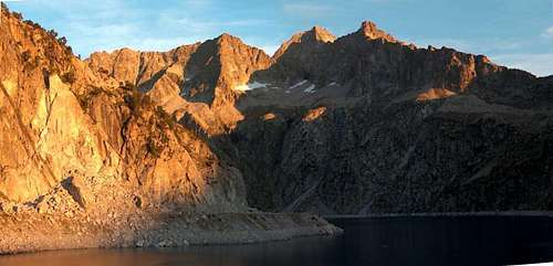
 Panoramic view of the Badet/Pic Long
Red Tape
 Les Laquettes
 Les Laquettes
The regulations of the Natural parc specify that :
- One can wildcamp or bicouac in mountains as far as one hour of walk away minimum from a road, only during the night or by bad weather, between 19pm and 9am.
- Dogs forbidden
- Fires forbidden
- Rubbish forbidden
- Flower-picking forbidden, no Hunting
- Motors (4x4, motorbikes) forbidden
- Mountain bike authorized only on designated tracks
- Paragliding forbidden
- No noise...
- Fishing allowed in certain conditions. Regulations even more complex for subalpine mountain lakes.
Sleeping
 Refuge Packe
 Refuge of La Glère
 View from refuge de Bastan
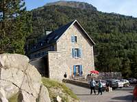 Chalet d'orédon
Bivouacking, wild-camping
As mentioned in the red tape, overnight camping is allowed, if your tent is located at least 1 hour away from any road or mountain hut. Camping near mountain huts, using them only for eating and toilets purposes is allowed, despite it can be a surprising attitude in other countries. Removing the tent in the morning is required, despite leaving it the time of the hike is usually tolerated.
Unguarded huts and shelters
The Pyrenees have an incredible amount of places of this kind, which are inventoried in this fantastic site : www.pyrenees-refuges.com. This interactive map allows to locate them : http://www.geopyrenees.net (click "cabanes"). Few of them are very famous and useful in the Néouvielle area : Refuge Packe, Cabanes of Rabiet, Coste Oueillere, Port-Biehl, Aygues-Cluses, Sardiche.
Official Campsites
One will find several convenient campsites in Saint-Lary and the Aure valley.
Guarded Mountain huts & alpine hôtels
Most of the artificial lakes with dams used to have a building next to them, for construction and maintainance purposes, and these are nowadays reconverted into well-located mountain huts (Bastan, not managed by the CAF but ASPTT is the only exception to this rule). Some of them are served (or nearly) with roads, but kept their alpine character.
- Refuge-Hôtel du Lac d'Orédon
- Chalet-refuge de l'Oule
- Refuge de Bastan
- Refuge du Campana de Cloutou
- Refuge de la Glère
Accomodations in the valleys
All the previously mentionned valleys have a crowd of possible accomodations. The most simple is to type places names in Google, or to check the touristic portals of these resorts and valleys:
- www.vallee-aure.com
- www.paysdesnestes.fr
- www.saintlary.com
- www.campan-pyrenees.com
- www.bareges.com
- www.gavarnie.com
- www.lestoys.com
One accommodation is worth mention for large groups of people: La Filature (former spinning mill), in Ancizan, with further information here and here (French). Prices can go as low as 10€ for groups over 10 people. A separate apartment is available too but rates may vary depending on the charges being shared with others or not.
Maps
Numeric mapsDue to the copyright policy of the IGN, it is not possible to scan and include map samples without permission. The only way to consult them online is via the database Géoportail, easily browsable via the site ClicGPX (we need to unzoom, move to the central Pyrenees and rezoom again)
Paper maps
Two types of maps are usually found in France for the Pyrenees :
- The TOP 25 series of IGN, high quality maps at the 1/25000 scale, are mandatory for hiking the high regions and offtrail terrain. One map covers most the area described in this page: 1748ET (Aure & Néouvielle). The northernmost part near the Tourmalet is covered in the 1747ET (Bagnères). See the France index for a more accurate look.
- The Rando Editions series, at the 1/50000 scale. This kind of map is usually enough if we stick to the trails, as well as for the softer relief. One whole map covers the whole area : the N° 4 Bigorre.

