
|
|
Mountain/Rock |
|---|---|
|
|
15.74288°S / 71.53771°W |
|
|
Download GPX » View Route on Map |
|
|
Hiking, Scrambling |
|
|
Spring, Summer, Fall, Winter |
|
|
17257 ft / 5260 m |
|
|
Overview
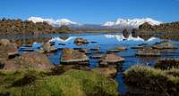
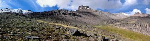
Ampato, Sabancaya and Hualca Hualca
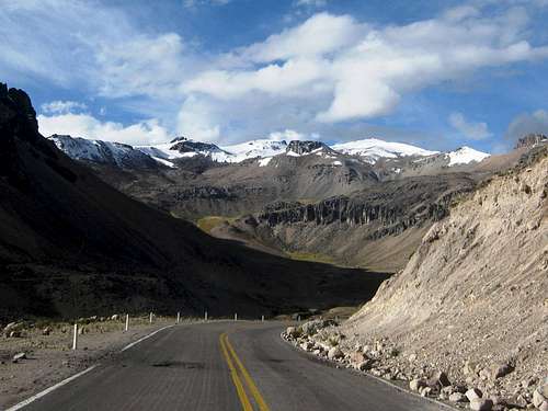
Nevado Chucura from the road in Quebrada Chucura. The summit is the snowy peak just right of center.
The mountain is close to the main road between Arequipa and Chivay. You can see it up close from where the road crosses Quebrada Chucura, the valley southwest of the summit. There are a few simple huts near the road, a bit further downstream in the valley, and you stand a good chance of seeing alpacas or llamas wandering about.
The prominence of Nevado Chucura is pretty small: to the east, the ridge drops to about 5200m, before rising again to a peak of around 5310m, which marks the start of the south ridge of Huarancante. Still, Nevado Chucura can be seen from the road at Quebrada Chucura, but Point 5310 cannot, which, perhaps, is why Chucura has a name of its own.
 |
 |
Note: Since Nevado Chucura is very close to Nevado Huarancante, a lot of information for the two peaks is the same. I chose to repeat it here, so the Chucura page can be used independently.
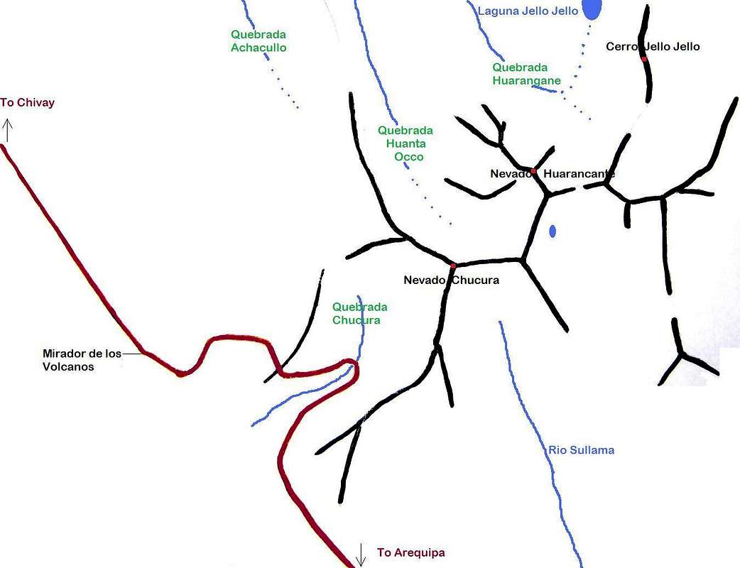
Getting There
Arequipa is the nearest airport, with many daily connections with Lima and a few with other Peruvian airports. In addition, several companies offer long distance bus transport. A lot cheaper, but more time consuming. I flew into Arequipa from Lima, and later I departed on a night bus to Cuzco.
Arequipa airport

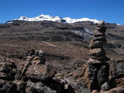
Millions of cairns at the Mirador de los volcanes
From Chivay to the Mirador de los volcanes takes the better part of an hour by public bus, depending on the engine - the bus has to climb 1200m or so, up a long and winding road. Going down takes just half an hour.
Routes
NW ridge
For the ascent, the easiest route starts at the Mirador de los Volcanes. It's about 350m elevation gain. From the Mirador, Nevado Chucura cannot be seen very well. On a direct line, the summit is about 5km ENE, but to avoid having to descend a bit along the way, start off by hiking up the gentle slope to the northeast, heading 40°.
A few minutes from the Mirador you get to see Nevado Chucuru, right of center. On the left, and further away, is Nevado Huarancante. Look closely, and you'll make out the telecom tower. Easier to spot is the winding dirt road just ahead.

The dirt road at the turnoff NW of the Mirador

The telecom tower
If you have your own transport, you can actually drive as far as the tower. There are two turnoffs from the main road that can get you there. One is about 2km NW of the Mirador (-15.7564,-71.5752), heading east, the other one is about 1 km SE of the Mirador (-15.7388,-71.5918), heading north. On my first encounter with the area, I camped just northwest of Chucura. I hiked out along this road for a bit and it was in good shape. You might even be able to drive it with a regular car, but a 4x4 would be a safer bet. The tower is already visible at the turnoff. I can't vouch for the condition of the other road. No matter which one of these two you take, soon you'll reach a junction with a smaller road leading to the tower itself.

Point 5310 and Nevado Chucura from the final part of the NW ridge

View towards the tower from the summit of Chucura - enlarge for a better view
E ridge
 View along the south ridge of Huarancante to Pt 5310
 Pt 5310 from the west
 Chucura from the east ridge - view along the N slope
 Chucura from the east ridge - view along the S slope
 Chucura:The summit rocks from the east
 A tired dude on the summit
Slightly over 1km east of Chucura, and connectedby a wide ridge, is an unnamed summit, ca. 5310m. There was one place along this ridge where I used my hands for a short and easy scramble. You can get to Pt 5310 by descending Nevado Huarancante along its south ridge.
SW slope
The big rocky foresummit from the west

The NW ridge from Huanta Occo
If you're already acclimatized, climbing Chucura won't take more than a few hours. With more time, it can be combined with Nevado Huarancante. With only a day pack, you can climb both in one long day. With two days, you can camp in Quebrada Huanta Occo (a short first day) or somewhere north of Huarancante, and make a grand traverse of Huarancante, Pt 5310 and Chucura on the second day. A really enjoyable trip!
The GPX-file attached to the page displays a multi-day trip, ending with this traverse. See the Routes chapter of Nevado Huarancante for an embedded map.
 Nevado Chucura 360° summit panorama. Nevado Chucura 360° summit panorama.On the left, far away to the south, looms the dark volcanic cone of Misti, with a friendlier looking Chachani to its right. If you scroll about a third to the right, you'll see Ampato, Sabancaya and Hualca Hualca, somewhat obscured by clouds. If you scroll further to the right, you first pass the northwest ridge of Chucura, and then comes next door neighbor Nevado Huarancante, covered in snow, looking beautiful. |
Red Tape

Chachani from Chucura
Accommodation and Camping
There are lots of hotels in Chivay and Arequipa. Between treks and climbs, I stayed in Casa de Melgar, a nice midrange hotel in the center of Arequipa.
Rime on my tent, NW of Chucura
In Arequipa, the best place I found for buying supplies was the big Plaza Vea supermarket at Avenida La Marina 300. Chivay has a well stocked open market in the town center.
When to Go
Chucura is low enough to be safe to go all year round. Temperatures usually drop below freezing at night, but as soon as the sun comes out it's not really cold anymore. Peru being close to the equator, it's not much colder in the dry winter months of June thru August. If you have a choice, you might want to avoid the rainy season, from December to March. That said, with snow on it, the mountain is a lot more interesting, so the ideal time would be during a dry period in, or just after the rainy season, or after an unseasonal bit of snowfall later on.Note: At just over 3600m, Chivay lies much lower than Nevado Chucura.
Gear

Lizard in Quebrada Achacullo, NE of Chucura
Maps
Frankly, there are no good maps of the area. The best one in existence is the Peruvian IGN sheet 2539 Chivay, 1:100 000.The small print on the map says that it's based on aerial stereophotography from 1955, but during my time in the area I found that I could trust the geographical features, notably the relative altitudes of the valleys, ridges and peaks, as denoted by the contours, very well. As for human-made features like roads? Well, that's a totally different matter. I learned not to trust the map on that point.
External Links
The two agencies where I dropped in from time to time and got useful information about the area:Quechua Exploring, Calle Ugarte 109 Cercado Arequipa.
Carlos Zarate, Calle Santa Catalina 204, Arequipa.