
-
 8441 Hits
-
 76.66% Score
-
 7 Votes
|
|
Route |
|---|---|
|
|
49.64670°N / 115.485°W |
|
|
Hiking, Scrambling |
|
|
Summer |
|
|
Overview
The scramble up Mount Fisher would have to be considered one of the best day outings in the east Kootenay area. Starting with a beautiful trail through the forest, you continue on to see boulder fields, streams, tarns, a waterfall, and incredible views of the Rockies, the Purcells, and the Rocky Mountain Trench dividing the two ranges. It is no wonder that Mount Fisher is as popular of an objective as it is. The round trip distance from the trailhead to the summit and back is 10km and the terrain is usually steep. The elevation gain to the summit is 1400m (4600 ft.). The average person will take 5 hours to reach the summit.Due to its prominence in the area and its proximity to Cranbrook, Mount Fisher can get people attempting it that may not even have previous hiking experience. I personally would not recommend attempting Fisher without some previous hiking and scrambling experience. It is a long, steep, physically demanding day. It is a class 2 route involving some exposure and some routefinding. You will definitely be using your hands a considerable amount on the ascent and descent of the steep scree/gravel gully leading up to the saddle as well as on a few more difficult moves near the summit. A crux move just before the summit will just be another day out to some, while being very intimidating to the inexperienced. Some hiking and scrambling experience is wise before attempting Mount Fisher.
For those choosing to make a run at Mount Fisher’s summit regardless of experience, please be very careful not to dislodge any loose rock – especially in the gully leading to the saddle south of the peak. In the event that one should come loose, it is paramount that you yell “ROCK” to warn others below you that a rock may be coming their way.
Topo Map: Fernie 82G/11 (some literature lists both Fernie 82G/11 & Cranbrook 82G/12)
Cranbrook Forest District Recreation Map #33
Route Description
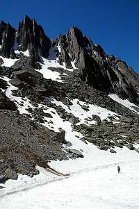
See the “Getting There” section of the main page for information on getting to the trailhead.From the trailhead, take the switchbacking trail into the forest. The trail is very clear and easy to follow. When you reach sections of talus and boulder fields, there are usually sufficient cairns to easily keep you on the route. Continue to follow the trail until you reach the first of two cirques (the first being less defined than the upper one). From here, continue up the talus trail until you reach the upper cirque with its several tarns. The gully which will lead you to the saddle south of the summit is at the back of this cirque on the left (NW) side. Scramble up this steep rock, scree, and gravel gully. A helmet wouldn’t be a bad thing to have in this gully, despite the fact that you probably won’t see any people wearing helmets on the mountain. There is a considerable risk of rockfall in this gully, especially if there is an inexperienced party ahead of you.
From the south saddle below the peak follow faint, yet easy to follow, trails up towards the summit. Upon meeting a descending party as we were going up, they told us “The cairns don’t lie.” That is my advice also. The cairns didn’t lie. Whenever a faint trail leads you to an overly exposed spot, backtrack and you will find a better route. You shouldn’t have to face any significant exposure until one move just before the summit. We generally stayed to the right hand side on our way to the summit. Some trails wandered left but we avoided them due to the snow which still existed there. I have read literature attesting both to sticking to the right and to the left. I can only say that the trail that stays more to the right is a pleasant ascent and that the “cairns didn’t lie.”
Within spitting distance of the summit, there is one interesting scrambling move to get around before the last easy walk to the summit. The summit is a true pinnacle of a peak with only room for one or two people on it at a time. The views are breathtaking in every direction. To the east, you can see mountains as far away as the Crowsnest Pass. To the south, you look down on the formidable Steeples and see the Kootenay river winding its way toward the horizon. To the north, the Rocky Mountains continue on uninterrupted and to the west the Rocky Mountain Trench lies below you with the majestic Purcell Mountain Range sitting on the horizon.
After breathing in all the beauty the summit has to offer, descend the same way you came up. The steep trail provides a challenging end to this great day out.
Essential Gear
Standard day hike gearProper hiking footwear
Warm clothes
Rain gear
Also recommended:
Helmet - Although most people you see on the mountain aren't wearing helmets, I would recommend wearing one while on the scree slope and gully leading up to the saddle.
Ice Axe - For early/late season attempts.
Hiking poles
Bear spray