|
|
Route |
|---|---|
|
|
37.06670°N / 3.3667°W |
|
|
Hike, some scree and rocks close to the summit |
|
|
Half a day |
|
|
Walk up |
|
|
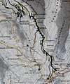
Approach
Use the road from Granada to Prado Llano, the industrial skiing area in the Sierra Nevada. From there, further up the road, you'll reach Hoya de la Mora (2.250m), where the trail begins just above the parking lots.
Route Description
The easiest, safest and least attractive way is to simply follow the road. An alternative is to use the trail which starts right at the control point (you'll remark a Madonna statue to your left: that's where you have to go to). The trail itself is not marked well and can be difficult to find during bad weather conditions. In parts, you will have to cross the road (which can be helpful for orientation). Once you are high above the skiing area and the new observatory, you can access the summit by a straight hike over scree and rocks.
 |
Essential Gear
Depending on season and weather take appropriate hiking gear with you (boots, rain gear, map, compass, etc.)
Miscellaneous Info
If you have information about this route that doesn't pertain to any of the other sections, please add it here.
Diego Sahagún - Sep 22, 2004 12:58 pm - Hasn't voted
Route CommentI thought that I should improve this page with more information about the route. As well, you could start higher, at Albergue Universitario (2.550 m).