
-
 6889 Hits
-
 76.66% Score
-
 7 Votes
|
|
Route |
|---|---|
|
|
45.97080°N / 7.60410°E |
|
|
Mountaineering |
|
|
Summer |
|
|
A long day |
|
|
II |
|
|
Overview
The “Normal route” from the Italian (South) side to Dent d’Herens.It is a long and demanding climbing along the Grand Muraille glacer (crevasses!). Once reached the upper part of the glacier, approximatly in correspondence of the south-east ridge, traverse all the south face of Dent, in parallel along the terminal crevasse, then with a diagonal climb, reach the west snowy ridge, at a small saddle between the Tieftmattenjock and the top.
While you climb the south face, remember to move in direction of the west ridge, quite far from the top, where it seems to be reachable. DO NOT try to ascent directly to the top.
This way is advisable only when the south face is fully covered of hard snow and with low temperature. Otherwise great danger for the falling stones!
Getting There
The Refuge Aosta (2781m tel +39.0165.73.00.06) lies at the top of Valpelline. Very comfortable, is located on a rocky step between the glacier de Tsan (north) and glacier des Grandes Murailles (east).From Italy. Live the Highway at the exit Aosta- Gran San bernardo and then follow to Gran San Bernardo pass. Then look for the indication Valeplline. At the village of Valpelline turn right till lake of Place Moulin(1968 m) where you can park your car. From there, easy path n° 10 to ref. Prayer (1h) and then ref Aosta (3 hours, total about 4h).
From Swiss: From cabane de la Dent Blanche through the Col de Valpelline (3568 m), or from Zermatt through Tiefmatten pass (3585 m). Both across glacier, not very advisable.
Route Description
Leave the refuge Aosta between 2:30 or 3 AM descending for about 100m and then rise along a steeped path on the lateral moraine of the grand Murailles Glacer.When the path get much less steeped and almost flat continue in direction of the front of the glacier of Gran Murailles (in 2007 it was a stepped, about 45° and with many serracs).
Follow the path and the easiest way to surmount it (about 300 meters) then just continue on the upper flat part. Attention to the crevasses. About after 1 hours you can recognise the lateral trace to the Tieftmatten pass, in direction of an evident red-yellow gendarme. For the Normal route then continue straight ahead on the east direction to the upper part of the glacier (another step of about 300 meters) in direction of the south-east ridge coming down from the top.
Then fronting the south side of the mountains traverse in west direction (left) walking almost in parallel along the terminal crevasse and then pass it on the extreme left, where is narrower. Look for a sort of rocky pillar (sometimes with a signal made by stones) with a sort of path that and then keep climbing on the south face with a diagonal movement in direction to the west ridge. Look carefully for signals and also follow where the way seems to be easy. There are a couple of channels and rocy easy dieders to climb. It is the right direction.
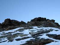
Once reached the west ridge in its snowy part (sometimes a stone signal, otherwise try to remember this small saddle to recognise it when you go down!) just follow in direction of the top. About 200 meters of very steeped snow with some ice and stones, then you arrive at a rocky part with two easy dieders (II) and then the last final ridge, sharp, exposed with an impressive view on the north face.


Essential Gear
Helmet, roops, crampons, axe, ice screw, maybe 1-2 camalot or 1-2 intermediate nuts. Rope rings.At the top of the west ridge, when there is the rocky part, there are pitons and rings for repell down placed about 25-30 meters.