
|
|
Route |
|---|---|
|
|
39.04250°N / 106.5969°W |
|
|
hike and snow climb |
|
|
Most of a day |
|
|
hike: 2+, snow climb: steep snow (45 degrees) |
|
|
Approach
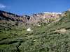
Start from the Grizzly Reservoir trailhead, at 10560 feet.
To access the trailhead from Colorado 82 (between Independence Pass and Aspen), go 6.4 miles on a dirt road (Lincoln Creek Road) accessible to all vehicles (though, a regular passenger car can touch a few times some rocks). The trailhead is 0.3 mile after the dam.
Route Description
Hike 3.2 mile on an easy path up to Grizzly Lake located at 12500 feet. On the way to the lake, you have to cross to the west side of Grizzly creek at 11420 feet (which is not problem in summer, but might be difficult or impossible otherwise).
Once at the lake, go around the lake on the north side (as told by guide books - though you might try the south side as well) and reach the snow field. You are now standing at the bottom of the north couloir, the widest of all couloir you can see, steepening at around 45 degrees. The way up is obvious.
Once on the ridge of Grizzly, hike south 0.2 mile to the summit (class 2+).
Instead of going back down the same way, go down through the west face, which is a class 2+ route. From the summit, stay on the ridge and go south 0.3 mile. When reaching the basin located between Grizzly and the next summit (Garfield peak), go straight down the west face in the gulley. After some loose talus scrambling, you will reach grass fields, and then forest. There is no marked trail, but the route is obvious to reach the river flowing at the bottom of the valley down to the dam where you parked.
Walk down the 2.5 miles to the parking lot (or hitch-hike any 4x4 truck that would luckily go down this 4-wheel road).
 |  |  |  |  |
Essential Gear
For the snow couloir climb, an ice axe is essential given the steepness. In the summer (snow holds well in the couloir until mid-summer), crampons are not absolutely mandatory but might help in some sections.
Miscellaneous Info
If you have information about this route that doesn't pertain to any of the other sections, please add it here.
Liba Kopeckova - Jun 25, 2015 10:34 am - Voted 8/10
Grizzly CouloirA great way to get up this high 13er. I would not take my regular car on Lincoln Rd. It was pretty rough and bumpy. The hike up up to Grizzly Lake, up Grizzly Couloir, summit and descent via Western slopes (between Grizzly and Garfield) is longer than Gerry Roach's book describes - my partner got on his GPS over 11 miles (we were bushwhacking western slopes since there was still some snow at lower sections and we did lost the existing semi-trail).