
|
|
Mountain/Rock |
|---|---|
|
|
48.31251°N / 121.60372°W |
|
|
Skagit |
|
|
Hiking, Mountaineering |
|
|
Spring, Summer, Fall, Winter |
|
|
3840 ft / 1170 m |
|
|
Overview
North Mountain is a peak located immediately north of the city of Darrington, Washington. With vast forested slopes but no highly distinguishable summit, North Mountain would likely go unnoticed by most peakbaggers if it were not for two major reasons. One attraction for potential peakbaggers is that the false summit has a large fire lookout atop it. Another attraction for potential peakbaggers is that North Mountain is one of Washington's peaks with over 2000' of prominence. North Mountain (Photo Taken By Eric Noel)
Unfortunately, North Mountain might soon be an attraction for peakbaggers for only one reason. The mountain is not likely to suddenly lose its prominence, so that leaves the status of the fire lookout as soon-to-be disregarded aspect of the mountain. In 2009, the Darrington Ranger District announced its plans to tear down the popular fire lookout in the near future.
 Fire Lookout As Seen From Slopes Of True Summit Area
In 1962, a tent campsite was established on North Mountain's northern false summit, and the tent lookout facility remained active for four years. Then, in 1966, a 41'-tall treated timber fire lookout with an "R-6" cabin was officially built by the U.S. Forest Service. The fire lookout remained operational until the late 1980s, and then was only officially used on an emergency basis from then on. Then, in 2006, the Darrington Ranger District setup a locked gate approximately 1.25 miles of road from the lookout site, hoping to curb vandalism that had plagued the lookout site for many years. Later, in 2009, the Darrington Ranger District made the following announcement on its website: North Mountain Lookout retirement – move Forest Service radio repeater from North Mtn. Lookout to a new site on Segelsen Ridge, and tear down North Mtn. Lookout. T33N, R09E, Sec.26, north of Darrington, WA. The Darrington Ranger District also locked the lookout, blocking access to its top cabin and outward views. Some hiking groups are loosely planning to fight the lookout dismantlement plan, but unless something is done the fire lookout will be torn down sometime during 2010.
 North Mountain Fire Lookout
No matter what happens to North Mountain's fire lookout, one aspect of North Mountain will always remain intact: its prominence. North Mountain, with 2200' of prominence, is one of Washington's 144 peaks with at least 2000' of prominence, ranking 109th on that list. At first glance from the peak's base, it might not seem apparent that North Mountain has such large prominence, especially due to the peak's modest overall elevation (3840'+) and being regularly overlooked by its more-prominent and popular neighbor to the south... Whitehorse Mountain.
 Whitehorse Mountain, As Seen From North Mountain Summit
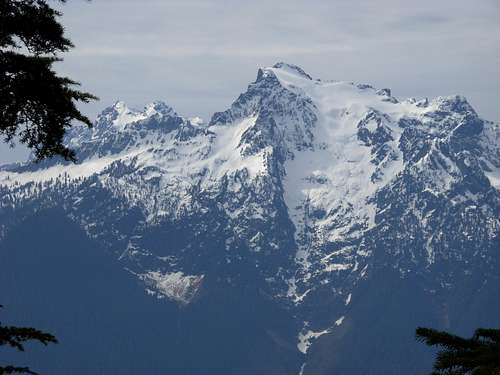
Different sections of North Mountain's summit ridge offers fantastic views in different directions. The top of the fire lookout, if open, would offer a 360-degree panoramic view. Otherwise, much of the northern false summit area, where the lookout has been stationed, is largely surrounded by trees that prohibit unobstructed views. The true summit area is also largely surrounded by trees but has open eastern views, as well as views in each of the other directions (north, south, west) from different areas near the true summit. It could be suggested that the rocky and densely forested summit area is worth exploring for those views, alone, on a clear day. Views of major nearby peaks including Mount Baker, Whitehorse Mountain, White Chuck Mountain, Pugh Mountain, Sloan Peak, and various peaks of the North Cascades (including the Picket Range) can be seen from different sections of the North Mountain summit ridge.
 View Of Picket Range From North Mountain (Photo Taken By Paul Klenke)
North Mountain can be summited year-round. However, reaching the true summit is perhaps most advisable between late Autumn and mid-Spring months while the most leaves and growth are not as prevalent as during the rest of the year. This is especially notable while travelling off-road through thick forested sections and while traversing along the summit ridge.
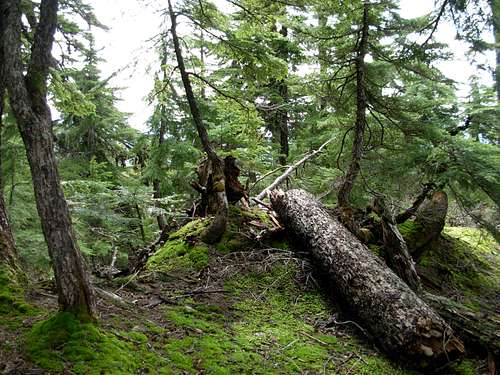
 Thick Forest Growth Near True Summit
North Mountain was named as such by USGS surveyors, in reference to the peak's position directly north of the Skagit County-Snohomish County boundary line.
Getting There
FROM THE DARRINGTON RANGER STATION ALONG HIGHWAY 530 IN DARRINGTON, WA:
1) Drive north along Highway 530 for 0.6 miles.
2) Turn left onto North Mountain Road. This road is also known as FS-2810 and FS-2811. There might not be a road-marker sign along Highway 530. However, this is the same road that leads to, and beyond, Whitehorse County Park (which is only 0.1 miles down the road).
3) Follow North Mountain Road/FS-2810/FS-2811. The road is one-lane and paved for the first 2.8 miles, then becoming gravel and dirt the rest of the way up the mountain. Continue following the main road, not making left or right turns, that leads up the mountain.
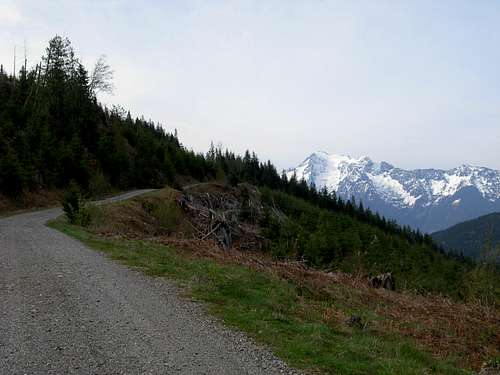 Driving Up North Mountain Road (a.k.a. FS-2810, FS-2811)
4) From Highway 530, follow North Mountain Road/FS-2810/FS-2811 for 11.5 miles to a small automobile turnout (~3300' elevation) for parking. A locked gate is only a few hundred feet away from the parking area.
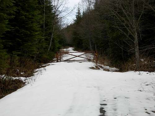 Locked Gate On North Mountain Road
HIKING INSTRUCTIONS TO THE SITE OF THE FIRE LOOKOUT (FALSE SUMMIT):
From the locked gate, continue following the road for approximately 1.25 miles to the site of the North Mountain fire lookout (3824' elevation).
HIKING INSTRUCTIONS TO THE TRUE SUMMIT:
OPTION 1:
1) From the locked gate, continue following the road for approximately 1.00 mile until finding a very old, overgrown south-trending logging road veering south from the left side of the lookout road. The hill containing the true summit might occasionally come into view.
2) Continue following overgrown, slide alder-consumed road, passing by a minor rocky false summit on the west side of the road, for approximately 0.5 miles until reaching the steep hill leading to the true summit area.
 Looking At True Summit From Minor Middle False Summit
3) Begin hiking off-road and uphill to the true summit area.
 One Of Possible Locations Of True Summit
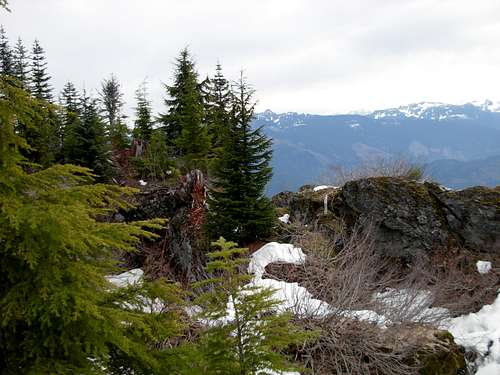
4) The top of the hill containing the true summit is a series of steep rock outcrops and small rocky ridges surrounded by forests. The exact location of the true summit is disputable, as the summit area has a 40-foot closed-contour ranging between 3840'-3880' elevation. Several of the possible highest points are easily seen while others are not. True peakbaggers will make an effort to reach each of the possible highpoints.
 Rocky Outcrops And Uplifts At Summit Area
OPTION 2:
1) From the fire lookout site (northern false summit), head off-trail through thick forest due south, passing by a minor false summit on the middle of the summit ridgetop, for approximately 0.5 miles until reaching the steep hill leading to the true summit area. The forested areas are very thick with groundcover and branches, making this possibly the least desirable summit route option.
2) Begin hiking uphill to the true summit area.
 One Of Possible Locations Of True Summit
3) The top of the hill containing the true summit is a series of steep rock outcrops and small rocky ridges surrounded by forests. The exact location of the true summit is disputable, as the summit area has a 40-foot closed-contour ranging between 3840'-3880' elevation. Several of the possible highest points are easily seen while others are not. True peakbaggers will make an effort to reach each of the possible highpoints.
 Mount Baker, As Seen From North Mountain (Photo Taken By Paul Klenke)
OPTION 3:
From the locked gate on North Mountain Road, there is an old logging road veering right (southeast) just prior to the gate. According to some maps, that old road leads southeast and then northeast towards the hill containing the true summit. This road route to the base of the summit hill has yet to be officially verified. However, if this side-road did lead to the base of the hill containing the true summit, it would diminish the length of the summit trek. The route would only be approximately 1.5 miles roundtrip rather than 1.5 miles each way (as is the case for the standard options listed above). Also, it would negate the necessity to bother with the northern false summit, especially if the fire lookout is removed and there is no longer a favorable reason to go there.
Red Tape
There are no fees or permits required to park or hike North Mountain.North Mountain Road (a.k.a. FS-2810, FS-2811), that switchbacks up the mountain's western slopes, is a one-lane road with few side pullouts. Use extreme caution while driving on the road, in case of oncoming vehicles or wild animals crossing the road.
Many of the mountain slopes are on a permanent "timber sale" basis. As such, clearcut slopes and logging trucks & machinery might be encountered at any time while driving North Mountain Road.
Camping
Several official campgrounds are found near Darrington, WA.For specific updated rules regarding camping on North Mountain, please contact the Darrington Ranger District.