
-
 8789 Hits
-
 71.06% Score
-
 1 Votes
|
|
Route |
|---|---|
|
|
68.19086°N / 14.29812°E |
|
|
Rock climb\scramble |
|
|
A long day |
|
|
5.5 |
|
|
Approach
See route description for the South Face, as this will be your descent route. There are two route approaches to the North Ridge.
Approach 1: When driving from Svolvær to Henningsvær, a tunnel is driven through. After the tunnel, there is a turn-off to the old dirt highway that climbs over the pass. Follow this road (4X4, mtn bike, or hike) to the pass. From the pass, follow a trail toward the summit of Glåmtinden. At a saddle follow a trail to the right. Traverse below other peaks until reaching the head of Djupforden valley. From the lowest point traverse RIGHT into the head of the valley below several cliffs. At a large coulior adjacent to the massive walls of Vågakallen proper, head up left until gaining the ridge. Do NOT continue along the ridge from the lowest point or col. While it is possible, it is difficult, grassy, loose, and exposed (see trip report for further info on the joys of this route). The advantages of this route is that it starts at a higher elevation, enjoys much high traversing above the bushwacking horrors below, and is fairly direct.
Approach 2: Park at Djupfjorden on road 816 on the way to Henningsvær. (see approach for South Face). Follow the fjord to the moraine, and continue on the south shore by the freshwater lake. This path goes through a small but dense conifer forest. The trail ends at a beautiful secluded beach at the far end of the fjord-like lake. From here there are faint intermittent trails heading up for the pass, but there will be some serious bush and fern wacking en route. When coming to wet slabs, they are easier to pass on the left.
Far up the valley one comes to a small depression/pasture area with large boulders and sheep trails. From here, the col is directly above and steep grassy slopes invite the climber upward. DON'T go there! It is off route. Instead head right to a wide coulior that leads directly to the base of the climb. See route photos. Advantages of this route is that you descend back to where you parked your car, and you climbed the WHOLE THING from sea level.
 |  |
Route Description
The coulior begins easily, and ends in moderately loose fourth class. Moving into the reddish rock is a little easier. Rope up after gaining the ridge.
Pitch 1-4. From the col at the head of the coulior, head right to a groove, (5.4). Mantle into the groove and climb it for about 4 meters, then head slightly left of the ridge crest, following short chimneys and ledges until reaching a large flat area (lunch ledge.) Most of this is 3rd 4th class scrambling, and is best simul-climbed.
Pitch 5 5.5 This is the prominent chimney right in the middle of the ridge proper. Climb over and between several large chockstones, then worm through an off width crack, or a wide stem. Exit to the right of a large chockstone at the top of the chimney.
Pitch 6-7 simul-climbing. From the top of the chimney, head slightly right to a gully. Climb left of the gully, and regain the ridge crest among big blocks.
Pitch 8-9 5.4-. Follow the ridge, up a couple of short interesting corners and small gullies to the base of a slab. Stay left of the ridge crest. Zoom up the exposed slab to a ledge at the base of a steeper slab.
Pitch 10 5.5 There are two hand cracks. The right looks easier and shorter, but ends with a nasty offwidth unseen from the base. The left is longer, and isn't really any more difficult, and ends cleanly at a ledge.
Pitch 11 5.5 crux. The moves on this pitch are no harder than elsewhere, but it's weird, and much more exposed.Creep under a bulge in the ridge to the right. This leads to a large solid flake. Follow this to it's end, then traverse carefully right. It can be wet here, and the holds are not obvious. There is an ancient piton in crumbly gray rock. Keep traversing to a chimney (almost a gully) that is easy, and leads back to the crest of the ridge. Pro is iffy, best if belayed, not simul-climbed.
Pitch 12 4th class. Scramble along the ridge crest to where it begins to flatten out, and turn into a hike. There is one last surprise. A deep cleft gouges across the entire ridge. It is possible to leap over this (belay from abundant horns and flakes) or to rappel into the cleft, and 4th class climb out the other side. From here, it's a short easy scramble to the summit.
Descent: See description for South Face.
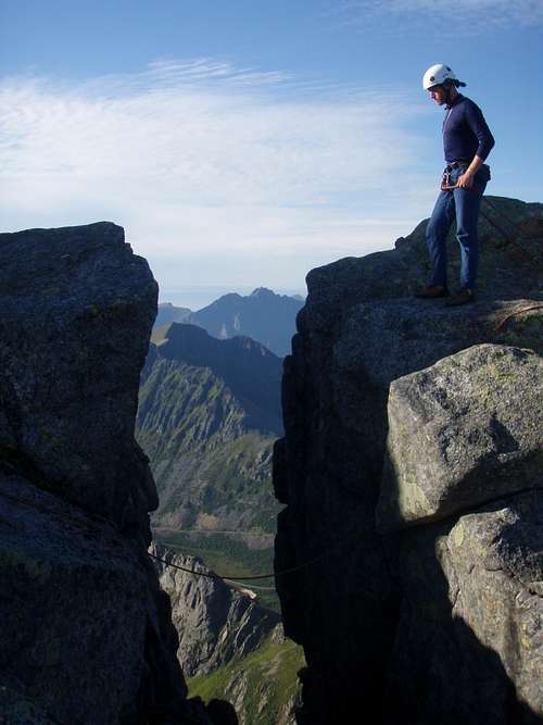
contemplating the gap and the jump.
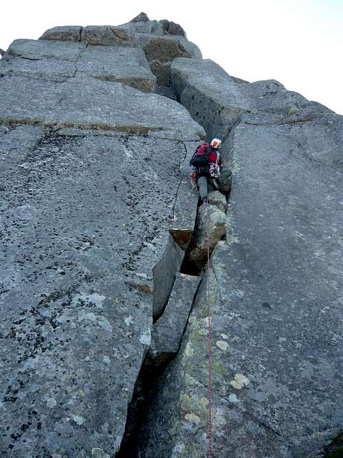
Starting the 1st of the 3 main pitches. A traditional chimney, with all the fun that can entail!
Essential Gear
One set of stoppers, Hexes or Tri-cams. 3 or 4 cams especially larger. One 60m rope. Sticky rubber approch shoes, or wear boots and carry rock climbing shoes. Runners for when the route wanders, and simulclimbing.
Why you should climb this route.
This is ridge climbing with lots of interesting route finding. Solid rock at the most difficult sections, and a good variety of climbing. Slabs, chimneys, loose ledges, grass filled gullies, cracks, leaps, this route has all the classic mountaineering difficulties. For added joy do it in clunky leather boots they way they did it back in 1939 during the first ascent. Climbing the North Ridge and descending the South Face gives a complete tour of the mountain.