
|
|
Route |
|---|---|
|
|
37.79750°N / 110.5834°W |
|
|
Hiking |
|
|
Spring, Summer, Fall, Winter |
|
|
Most of a day |
|
|
Class 2 |
|
|
Approach
See the getting there section on the main page for driving directions to the start of this route.Route Description
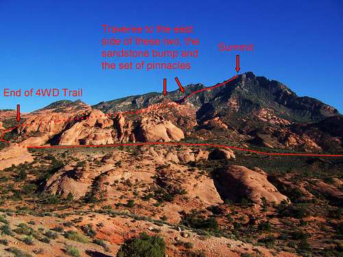 Route Diagram
As discussed on the main page the route I chose to describe for the page is, in my opinion, the easiest and most scenic. There is a dirt road that gets you closer to the peak but the ridge that you will ascend is steeper, looser with more brush and some traversing. I’ve done both routes and found this one described better for the page.
This route can be kept at entirely class 2 with careful route finding, but class 3 will probably be found along the way. The last 50 feet to the actual summit is only class 2. This route is much more steep than the pictures portray, be careful!
 Hike Overview
Round Trip Distance : Approximately 7 mi
Elevation Gain : 3000 ft
Start of Hike : N 37.8273 W -110.6027 (WGS 84)
Start of 4WD Trail : N 37.8274 W -110.6002 (WGS 84)
 Past the pinnacles
 On the North Ridge
Once you are on 276, near the start of the hike, the best place to park is just north of the start of hike point. About 1/3 a mile north of this starting point on 276, is a large pull off area on the west side of highway 276, park here.
Once parked walk south 1/3 a mile on 276 to the wash, you will ascend a small hill then descend it on 276 to the wash. Once in the wash follow it for 0.15 miles eastward to the start of the 4WD trail, listed above. Follow this fading 4WD trail as it starts to head towards Mount Holmes, then begins heading north towards an area with sandstone walls. The 4WD trail enters this area, and then ascends a notch where it ends. The 4WD Trail is about 1.25 miles long.
At the end of the 4WD Trail, you will be on the east side of the north ridge of Mount Holmes. Gain the ridge then follow it north towards Mount Holmes. At about 6200 feet traverse to the east side of the sandstone “bump” to avoid unnecessary elevation gain. Once around the bump you will have a good view of the rest of the way up. As the sandstone ends and the granite starts, there is a set of pinnacles to go around, traverse to the east side (left) of this. There are several chutes that look like they will take you over and around but most will be dead ends on a cliff.
Now you are around the pinnacles, continue heading up the north ridge, once again the intimidating western summit block looks highest but it is really the leftmost bump seen in this photo. Make your way towards the left side (east side) of that bump seen and you will find an easy class 2 chute with some talus to ascend (50 feet), ascend this and you will be at the summit of Mount Holmes. If you want to make the summit scramble more interesting head around to the right side, there are several class 3/4 routes up.