
|
|
Mountain/Rock |
|---|---|
|
|
46.10047°N / 68.85514°W |
|
|
Piscataquis |
|
|
Hiking |
|
|
Spring, Summer, Fall, Winter |
|
|
3144 ft / 958 m |
|
|
Overview
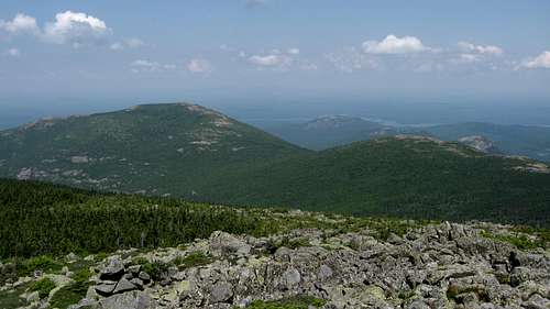
Just north of the Traveler (the highest volcanic mountain in Maine) lies one of its subsidiary peaks, North Traveler mountain. Rising over 2100 feet in little more than 2 miles from the trail head, and over 2500 feet from the lowlands to the East this is truly an important, imposing, and impressive mountain. (alliteration aside) From the start of the trail it ascends relentlessly, but the effort is not in vain. Soon after heading out, about a half mile in you are granted your first view, including; both South Branch Ponds; Black Cat Mountain; The Peak of Ridges; and of course, Katahdin. After that you come to view after view becoming more dramatic and panoramic as you climb. Most of the trail is exposed and you will walk across giant granite rock ledges, small talus fields, blueberry patches, and beautiful alpine meadows that invoke a truly serene feeling onto even the most metropolitan of us. The peak is nothing short of spectacular, with a 360 degree view of the Maine north woods and mountains, I would recommend this mountain to anyone who loves the wilderness in its true form as well as a little exposure. View SSW
Getting There
From Bangor, take 95N until exit 264 for ME-158 toward ME-11/Sherman/Patten. Turn left onto ME-158, then a slight right onto ME-11. Follow ME-11 then make a left onto ME-159/Shin Pond. Continue onto Grand Lake rd and enter Baxter park onto the park tote road, then make a left at the signs for South Branch Pond.Red Tape
Baxter Park limits the number of people allowed to enter each day so get in early (about 5:30 am during the busiest times). You also must sign in and out at the ranger station letting them know how many people are with your party, what time you departed, name, and whether you are camping or day-use.Camping
South Branch Pond CampgroundThere are 12 lean-tos, 21 tent/trailer sites, and an 8 person bunkhouse. These are all open May 15- Oct. 15. Fishing is allowed in the Ponds (fly fishing only), and you can rent canoes at the ranger station.
Outlying Sites
Upper So. Branch (1 Lean-to)
Pogy Pond (1 Lean-to)
So. Branch Canoe Site (1 Tent site, 1 Lean-to)
(ALL OUTLYING SITES ARE EITHER HIKE OR CANOE-IN)
Trout Brook Farm Campground
Holds 14 tent/trailer sites, 1 lean-to, and 4 group sites (site #1 holds 8 people, group sites 2-4 hold 14 people each). Fly fishing only.
Outlying Sites
North West Cove (1 Tent site)
Boody Brook (1 Tent site)
Little East (1 Lean-to, 1 Tent site)
Webster Stream (1 Lean-to)
Billfish Pond (1 Tent site)
Webster Outlet (1 Lean-to, 1 Tent site)
Long Pond Outlet (1 Tent site)
Little Coffeelos (1 Tent site)
Long Pond Pines (1 Tent site)
Telos Cut (1 Tent site)
Lower Fowler Outlet (1 Tent site)
Hudson Pond (1 Lean-to)
Lower Fowler Pond (1 Tent site)
Togue Ledge (1 Tent site)
Middle Fowler North (1 Tent site)
Pine Point (1 Tent site)
Middle Fowler South (1 Tent site)
Second Lake (1 Tent site)
K-P Dam (1 Tent site)
(ALL OUTLYING SITES ARE EITHER HIKE OR CANOE-IN)
For additional info. you can see Baxter State Park
What To Bring
Water, the spring that used to be advertised has since dried and has not been dug out. A sturdy pair of hiking boots, a whistle (I've seen Bear, Moose, and coyote droppings along the trail),a Camera Trust me the views are unforgettable. A jacket should be carried even in summer ,sunglasses, and lasty but probably most used... 100% DEET. If you use anything else the bugs will practically lick it off of your skin as if it were refreshing.Weather
In general for every 1000 feet you climb it cools by approximately 3-6 degrees (depending on other atmospheric factors), that combined with the Northernly latitude, elevation gain, and little-to-no cover on most of the trail can make for some hairy situations (if not prepared, even in the summer). This area by and large has very harsh winters with mild summers, but you can't rule out a snow/ice storm at any time. Wind Chill is a huge factor in this region, most of the entire Traveler Circuit is exposed SO PLEASE BE PREPARED.WEATHER FOR MILLINOCKET