
-
 8238 Hits
-
 78.27% Score
-
 9 Votes
|
|
Route |
|---|---|
|
|
46.68930°N / 110.8194°W |
|
|
Mountaineering |
|
|
Spring, Summer, Fall |
|
|
One to two days |
|
|
Class 4 |
|
|
II |
|
|
Overview
 Avalanche Canyon
The Northeast Chimney Route is an enjoyable snow climb located on the northeast face of Buck Mountain. The route climbs steeply from the south fork of Avalanche Canyon, though a short chimney high on the northeast face, at which point it joins the East Ridge route which can be followed to the summit. The route was first climbed by Fritiof Fryxell on August 15, 1931.
With an early morning start strong hikers may be able to complete the route in one long day. For the rest of us, a more realistic itinerary is to spread the hike over 2 days, with a camp established in the south fork of Avalanche Canyon. This will require a backcountry camping permit, available free of charge at the Jenny Lake Ranger Station. Refer to the Grand Teton camping guide for complete details on camping in the park.
Stats
 Buck Mountain NE Face
One-Way Hiking Distance: 5.5 miles
Elevation Gain: 5,313 ft.
Avg. Gain per Mile: 970 ft.
Trailhead Elevation: 6,625 ft.
Summit Elevation: 11,938 ft.
Route Description
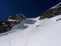
 Below the Lower Couloir
 Entering the Lower Couloir
 Looking Down from Lower Couloir
Please Note: This route description is based on early spring conditions, with extensive snow on the route. Route conditions will vary considerably from those encountered later in summer and autumn.
From the Taggart Lake trailhead proceed north on the Taggart Lake trail for ±1.1 miles to the junction with the Bradley Lake trail. Follow the right fork for ±0.25 mile, then head cross-county to the west towards Taggart Lake. Contour around the north shore of Taggart Lake to the far northwest shore of the lake, then proceed directly west into the mouth of Avalanche Canyon.
Follow an unmaintained hikers trail west along the Avalanche Canyon drainage, although the trail may be snowcovered in early spring. Approximately 1.5 miles from the canyon mouth, the south fork of Avalanche Canyon opens up on the left (south). Turn left and climb the short but steep headwall of the south fork. Peak 10,696 dominates the view directly to the south.
At the top of the headwall the canyon opens up, and the northeast face of Buck Mountain appears to southwest. Here the canyon flattens out briefly, and for those climbing the route as a multi-day backpacking trip this is a good area to establish camp.
Proceed directly towards the peak and begin ascending the broad snow slope (talus in summer) which lies at the base of the northeast face. The slope steepens as it gradually veers left into a couloir which climbs up to the large snowfield forming the upper bench on the face. Maximum steepness of the lower couloir is 40-45 degrees.
Above the lower couloir the slope decreases as it enters the upper bench, and the chimney comes into view on the right (west). Head up the gradually steepening slope, then ascend the short (80-100 ft.) chimney, which approaches 50-55 degrees near the top.
The chimney tops out on the east ridge of Buck Mountain at ±11,300 ft. elevation, and ±0.3 miles from the summit. From this point the ridge is followed to the summit as described in the East Ridge route.
Descent
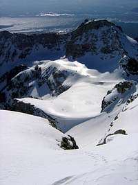
 Optional descent route
Descent can be made by reversing the route. An alternate descent option can be found approximately 200 yards further down from the point where the northeast chimney interesects the east ridge. From a small flat bench on the east ridge, drop north off the ridge (steep) back into the upper basin just below and to the east of the northeast chimney, then continue down into the south fork of Avalanche Canyon.
For those who have not left camping gear in Avalanche Canyon, it would also be possible to descend via the East Ridge or East Face routes.
Essential Gear
 Top of Chimney
An ice axe and crampons will be required. Individuals wishing to rope up will also require suitable snow protection gear.