
-
 3964 Hits
-
 78.27% Score
-
 9 Votes
|
|
Route |
|---|---|
|
|
44.94202°N / 111.46274°W |
|
|
Mountaineering, Scrambling |
|
|
Summer |
|
|
Half a day |
|
|
Class 3 |
|
|
Overview
To climb Echo Peak, most people use the Class 2 north ridge. In Select Peaks of Greater Yellowstone, author Thomas Turiano mentions a scrambling route on the east ridge but does not give more detail than that.
This route is a little shorter than both, combines parts of both (approach for the north ridge and scrambling on the east ridge), serves up some pleasant Class 3, and skirts an alpine tarn that probably very few ever get close to.
Interesting note: While many sources put the elevation for Echo Peak at 11,211', that elevation is actually for the "Roof" benchmark found a short distance south of the summit. The true summit has an interpolated elevation of 11,260'; my GPS device gave me 11,316', which would tie it with Hilgard Peak as the range highpoint. However, Hilgard is clearly higher, and my GPS device gave me 11,317' for it.
Getting There
Between Earthquake Lake and Hebgen Lake, turn off U.S. 287 onto signed Beaver Creek Road (FR 985). Drive about 4 miles to the road's end at Potamogeton Park. Two trails depart this spot. Use the first, more southerly one, not the one over by the pit toilet. The trail you want is the Sentinel Creek Trail, and it accesses Expedition Pass and Hilgard Basin, the latter of which is a highly scenic backpacking and fishing destination.
This road is a little rocky in spots but is suitable for most passenger vehicles.
Route Information
At the Sentinel Creek TH, a sign says it is 8 miles to the turnoff for Hilgard Basin. Turiano puts it at 7. My pace suggested it is closer to six, but let's split the difference and call it 7 miles.
Anyway, follow the trail until an intersection close to timberline. Bear left for Hilgard Basin. This intersection is NOT where the USGS Hilgard Peak quad shows it; it is higher up.
From the divide above Hilgard Basin, descend and then pick a campsite at or between Expedition Lake and Crag Lake. You will lose about 200' in doing so.
Early the next morning, strike out cross-country, using the good topo map you surely remembered to pack, for Thunderbolt Lake. Staying north of the lake, hike SW up tiring talus to the right of a waterfall (perhaps dry in late summer) to the vicinity of Point 10,290T. A small unnamed lake is just to the south.
 |
 |
 |
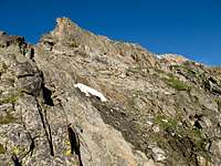
On the USGS Hilgard Peak quad, there is a marshy area just northeast of Echo's summit tucked in a small basin bounded by Echo's north ridge, east ridge, and a north-reaching spur of the east ridge.
In fact, this marshy area is an alpine tarn, or was so in late July 2012, and, at almost 10,560', it is the highest lake in the area and perhaps in all of the Madison Range. Scramble your way above and around this lake on its eastern side (while it's possible to make it harder than Class 3, it doesn't have to be harder than that) until you gain the crest of Echo's east ridge. Note: from Point 10,290T, you could actually follow the ridge south and wind up in the same spot, and probably on easier terrain. I opted for the approach I took because it looked more interesting and I wanted to get closer to the lake.
 |
 |
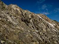
Now scramble up the east ridge (can be kept at Class 3) until you reach the summit ridge and then hike a short distance north to the highpoint.
 |
 |
One-way trail distance is 7.5-8 miles, with about 2600' of elevation gain and about 200' of loss.
One-way off-trail distance is about 2 miles, with approximately 1700' of elevation gain.
Essential Gear
Pack an axe and crampons and then from Hilgard Basin assess whether you will need them on climbing day. You cannot see the peak or the route from the road in.