
|
|
Route |
|---|---|
|
|
40.34670°N / 105.7364°W |
|
|
Scrambling |
|
|
A long day |
|
|
Class 3 |
|
|
Approach
This route starts from the summit of Stones Peak. See its page for how to reach it. In summary, from the Fern Lake TH, hike to Spruce Lake, bushwhack across Spruce Canyon to the southeast ridge of "Stapps," climb it and traverse southwest to Stones Peak.Route Description
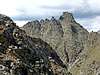
From the summit of Stones Peak (12,922 ft), descend southwest along the obvious ridge that leads to the saddle at 12,250 ft between Stones and Sprague. Avoid the difficulties on the crest of the ridge on either left or right. The first stretch of the northeast ridge of Sprague leads to a pronounced false summit along steep but uncomplicated terrain (Class 2).The last part of the ridge is narrower and made up of a series of gendarmes. It may be possible to keep the difficulties at Class 2 with careful routefinding, but at that point it looked faster and simpler to stow my trekking poles, take to the crest of the ridge, and enjoy some fun Class 3 scrambling. You reach the Continental Divide a short distance to the south of the summit cairn.
See the main page for a descent to the Bear Lake TH.
 |  |  |