
|
|
Route |
|---|---|
|
|
39.96655°N / 105.29077°W |
|
|
Hiking, Scrambling |
|
|
Spring, Summer, Fall |
|
|
Half a day |
|
|
Class 3 |
|
|
I |
|
|
Overview
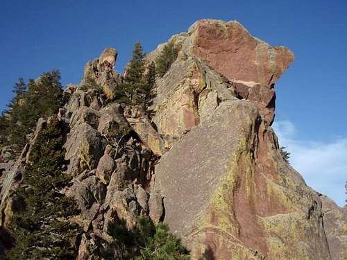 Nebel Horn from the Southwest.
This is the easiest route to the summit of Nebel Horn.
Getting There
Start at the NCAR Trailhead.Route Description
Stats: Class 3, 3.9 miles (round trip), 1460 feet of elevation gain.From the trailhead, follow the NCAR Trail (aka the Walter Orr Roberts Nature Trail) west for approximately 0.3 miles to a trail junction. At the junction, take the left trail which descends to the southwest. Follow the trail west for approximately 0.2 miles past a water tank to the intersection of the Mallory Cave Trail (if you go straight) and the Mesa Trail (if you go right or left). Go left (south) at this intersection. After about 0.6 miles from the trail intersection, the trail for Bear Canyon will branch to the right. Do not take the branch. Stay on the Mesa Trail for another 0.1 miles to the turnoff for the Fern Canyon Trail. Follow the Fern Canyon trail for 0.8 miles as it steadily climbs up to the saddle between Nebel Horn and Bear Peak. Once at the saddle, Nebel Horn can be seen to the northeast. The route to the summit from here is difficult to describe, but not too difficult to discover on one's own. Basically, from the saddle walk along a faint trail at the base of the northwest side of the Nebel Horn. Scramble upwards when the difficulty is no greater than class 3. If the difficulty looks harder than class 3, continue traversing to the northwest. |
Trail Profile and Map
The trail color represents the class of that portion of the trail.Green = Class 1
Purple = Class 3
Trail Profile The vertical unit is feet, and the horizontal unit is miles.  |
Map  Northwest Face from NCAR TH. Northwest Face from NCAR TH. |