
|
|
Route |
|---|---|
|
|
38.81300°N / 110.8546°W |
|
|
Hiking |
|
|
Spring, Summer, Fall, Winter |
|
|
Half a day |
|
|
Class 2 |
|
|
Approach
Depending on your vehicle, see the Getting There section on the main page for driving directions to the start of the routes mentioned.Route Description
 Hike Overview, Justensen Flats route in red, 4WD Trail route in yellow
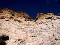 Chute to the summit
[img:474846:alignright:small:Close up of the start of the Ridge]
Both routes mentioned are about 8 miles roundtrip with about 1200 feet of elevation gain. However the route cross country from Justensen Flats will take longer because of its cross country nature, the route up the whole 4WD Trail is considerably easier
Round Trip Distance : Approximately 8 mi (same for starting at Justensen Flats or impassible part of Copper Globe Road). Distance is only 1 mi if you are able to drive all the way to the San Rafael Knob. Or if you start hiking at Justensen Flats and follow the Copper Globe Road, add 3 miles round trip.
Elevation Gain : Approximately 1200 ft (measured from impassible part of Copper Globe Road) About 1200 ft also from Justensen Flats Area with the ups and downs. If starting from the base of the San Rafael Knob, it’s only 500 feet of elevation gain.
If you are starting the hike from Justensen Flats you will have to make you own route for about 2.5 miles cross country, the Knob will be visible to the southeast the whole way. However, there are many washes to negotiate, as well as Devils Canyon, which is easily negotiated. It can be done at nothing harder than class 2. Making your way cross country, head towards the right side of the Knob. When the Knob is about a mile away, you will reach the 4WD Trail that is mentioned in the other route and have about a half mile walk to where the rock cairn is. See below.
If you are starting the hike from the impassible part of Copper Globe Road, or you can drive over it, see here. Continue about a ¼ west down Copper Globe Road where Devils Canyon breaks off the road and continues westward. Continue Following Copper Globe Road as it turns south, follow it for a short ways then enter the large wash on your left (not Devils Canyon). Follow this large wash for approximately ¼ mile to a 4WD trail head off to the southeast up another smaller wash.
Start of 4WD Trail: N 38.8328 W -110.8954 (WGS 84)
Rock Cairn on 4WD Trail indicating start of hike up the San Rafael Knob: N 38.81674 W -110.85558 (WGS 84)
Follow the 4WD trail for about 3 miles towards the San Rafael Knob, as you get near look for several rock cairns on the right that will direct you to the start of the trail. Coordinates are above. Follow the faint trail up the ridge seen in this photo. Follow this ridge (the ridge is hard to tell, but it starts mid left and goes up and right towards the center of the San Rafael Knob in the previous photo) as it gets near the sandstone wall seen near the top of the San Rafael Knob. Depending on your route finding (if you follow the faint trail) you will be able to stay on class 2 the entire way, but class 3 is easily found once off the trail. Once at the top of the ridge the trail traverses along the Knob to the left ridge where there is a flat spot as seen in the previous photo. A shot looking back from the flat spot. Once here the faint trail goes around the east side of the San Rafael Knob, and traverses the east side for about 500 hundred feet to where a chute heads up to the north. Follow this chute up for about 100 feet and to the left is the summit.