
|
|
Route |
|---|---|
|
|
40.67810°N / 111.0615°W |
|
|
Scramble |
|
|
Most of a day |
|
|
Class 2+ |
|
|
Approach
The Norway Flats Road branches off the north side of Highway 150, 10.6 miles east of Kamas. There is a sign marking the road. The road is good for the first mile, and then it quickly deteriorates into a 4wd road. Follow the 4wd road north staying on the main road that is marked for 4wd's (staying away from the forks marked for ATV use). Near the end of the main road there is a junction. Turn right along a less used road and follow the road to its end. If you reach a large lake, you're in the wrong place. Turn around and backtrack a short distance to the last junction and follow the less used road to its end. At the end of the road is a vehicle barrier trench and a singpost without a sign (late 1990's). This old blocked off road is the beginning of the trail.Route Description
From the trailhead, the trail heads east and drops rather steeply at first before leveling off after a short distance. After .5 miles from the trailhead, the trail reaches a marshy meadow and fades out. Pass the meadow on the west (left) side. At the north end of the meadow the trail becomes distinct again. The trail then climbs gently at first, but then climbs steeply to Big Elk Lake. Big Elk Lake is in a spectacular setting and is one of the most beautiful lakes in the Western Uintas.Wall Peak
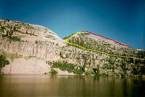
The trail to Big Elk Pass from Big Elk Lake is also inistinct. From Big Elk Lake, the route climbs steeply north to a bench. Watch carefully for cairns that mark the route. From the bench head west to a small pond. From this pond, the route heads west and up to Big Elk Pass. Wall Peak is reached from Big Elk Pass via a steep boulder-hop and scramble to the southwest and along the ridge southwest to the summit. There is another variation. Wall Peak can also be climbed from its southeast ridge. The southeast ridge is reached by heading cross-country to the pass southeast of Wall Peak from the ponds near Big Elk Pass mentioned above. From the pass, boulder-hop and scramble along the ridge to the summit. For a spectacular extension of the Wall Peak climb, continue south from the saddle just mentioned and follow the ridge (with scrambling and boulder-hopping) to peak 10,712. This is a spectacular ridge route with Big Elk Lake located directly below.
The round trip distance is about 4.8 miles to Wall Peak.
The final portion of the route:
Click for full sized map:
