But I also discovered the trail is regularly used by what I soon dubbed the “65 Mile Clubbers”. It turns out that folks come from all over to backpack Idaho’s Sawtooths “Grand Loop”, as one of them showed us excitedly on a map and book description at the trailhead. Personally, I could not imagine actually choosing to backpack the Baron Creek trail, the Alpine Way trail, and ultimately the South Fork Payette trail, all part of a 7 day slog-fest, and no peakbagging thrown into the mix. These were long, boring trails! No thanks. At any rate, different strokes for different folks: we met 18 such happy hikers along the trail who were all over it. Most were from back east, and the rest from Washington state. This is a most interesting take on the Sawtooths experience, we discussed. I decided we were sure lucky to be locals, to know more than the average joe about these mountains, and I gained another angle of gratitude for having the Sawtooths as my weekend playground. “Going to the Sawtooths” doesn’t have to be a lifetime bucket list thing for me, as is apparently true for others on the planet. So for my accumulated knowledge of the Sawtooths and its hidden treasures, I am eternally grateful.
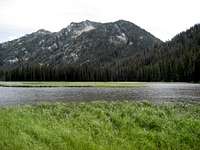
Elk Lake was surprisingly beautiful. My aforementioned friend and Google Earth had both painted a picture of a swampy mud bog. Instead, I found lush meadows of verdant green grasses, and a peaceful quietude that put my soul at rest... until the next morning.
Dismal Swamp
We set off from camp toward Fall Creek at 8:20 AM. Getting to Fall Creek “might be interesting”, we agreed reservedly, as we started across the pretty Elk Lake vicinity grasslands. By 8:30, we were both wet up to our thighs in marshy wetland mush. By 8:45, we had both sunk into the swampy waters over our boots and were now completely soaked. Over the course of the next hour and a half, we proceeded to slog through hell, we cursed like demons, and I started to lose track of how many times I thought about turning back. The marsh became a swamp, complete with standing trees, downed logs, and only got swampier the further we slogged maddeningly forward. We should try the Rakers again on another day, from a different direction, I thought, because this was insanity. I don't know how we got through it all without breaking a limb. Immediately after the experience was over, and even now, I cannot recall details of how we made it. Apparently, it was so bad that my brain won’t let me remember – PTSD, right? More importantly at the time, however, was how in the hell were we going to get back to camp?
Making it to a dry spot at the base of the mountain beyond the Swamp From Hell, we removed our boots and socks, had a snack, and attempted to put our senses back in order. My body was pegged from adrenaline, and I wondered how much juice I had left in me for the day and a climb up the drainage, let alone getting to the saddle between the Rakers, let alone a summit of the South Raker. Since we had made it this far, we discussed, we might as well continue on. And that was that. We put ourselves back together, pushed away painful thoughts of how we might have to go back through the swamp again later, and looked upward toward the thick, dark, forested mess that was the outlet of Fall Creek drainage.
Sidehill Salvation
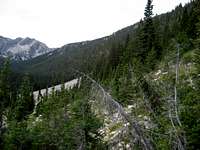
![Fall Creek, Headed Toward the Rakers or Bust]() Sidehill to Eternity
Sidehill to Eternity Another precious half hour was spent navigating a deadfall strewn path up the Fall Creek outlet. By 10:30, we landed on a rocky sidehill. This was most welcome, I decided. A mountainous side hill slog for hours ahead was far preferable to deadfall hell.
For the next couple hours, we made our way up the drainage along the steep, loose debris of a mountainside, which never let up. We took several breaks to give our limbs a rest, and to check the GPS for how much further it still was to that damn tarn. It seemed to take forever, and all we could see was forest ahead of us.
The Rakers Awaken
At 12:30, after an eternity of seeing little but forest and rocky mountainside, I suddenly caught sight between the trees of the North Raker, blazing reddish orange in the sun, and jutting defiantly skyward. Who invited you here? it seemed to ask menacingly. I felt as if we had awakened the dragon.
![North Raker View from lowest east tarn]() The Red Finger
The Red Finger
Ripping the Skyline Two minutes later, we arrived at the lowest tarn. Both out of water, and with me wired and tired, we sunk onto a rock sloping gently into the tarn and proceeded to filter water while catching furtive glimpses behind us at the amphitheater of Rakers.
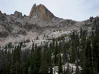
![South Raker (?) Upper Right, USGS South Raker in background; second/middle tarn below]() South Raker,
South Raker,
Upper Right; second tarn below;
USGS "South Raker" back leftWe lingered at the lower tarn for what must have been an hour, resting, airing our still-wet feet, gulping water, force-feeding lunch (lunch and exertion don't always go well together), wondering if the cloudy skies all around would not turn to thunder and rain, and otherwise just gawking into the Rakers amphitheater, trying to pick out a quick route to the saddle. My heart would alternately thud and sink as I slowly, achingly accepted that we did not have enough hours in the day, nor did I have energy left in my body to make it up to the saddle, let alone the summit, to come back down, to go back down the mountain to Fall Creek, and to spend another hour and a half of my life in that swamp. I accepted that I would have to be ok with my accomplishment to get as far as I did that day – with the help of my good friend, favorable weather, and the universe in general.
After agreeing that a climb to the Rakers’ saddle was not in the cards, we opted to hike over to the second tarn and examine the terrain with the limited time we had before our official turnaround time at 2 pm.
The second tarn was quite pretty, if not as inviting as the first. It sat down in a rather steep bowl, and seemed to glare up at me, as if it had never been visited by another human. Who do you think you are, coming here? it demanded. I looked away, unsettled, and up at the near vertical divide between the second and third tarn. “I don’t have it in me to go up that,” I told Alan. He agreed we should skip the third tarn. No reason to - this divide was the actual Rakers' ridgeline, I later realized.
Making our way along the 8600' high edge of the tarn basin, we were struck by the towering views all around us, looking east toward some very climbable (if not easily approachable) peaks 8787 and 9438, back north along the Cony Peak/Reward Peak divide and the SF Payette, and directly below into meandering Fall Creek and its wide U-shaped valley. We snapped pictures of these views, a few more of the Rakers, then set our sights for the Fall Creek meadow that was over a thousand feet of loose debris on a hard hillside, and straight down, below us.
The Way Home
An hour and a half later, we arrived at the meadow with its blazing white granite boulder fields, only to find the entire area another marsh.
![Fall Creek Meadow, Returning from the Rakers]() Fall Creek Meadow
Fall Creek MeadowThe boulders made it tricky, with deep holes between them, filled with murky water and brush. Wet shoes again. Sigh. At least it was pretty, with wildflowers, butterflies and bees everywhere, verdant green, and birds a-singing. The mountains don’t care, they just are.
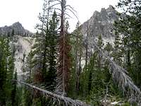
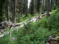
![Fall Creek Deadfall Hell]() Typical Fall Creek Deadfall
Typical Fall Creek Deadfall
We opted for a lower tour through Fall Creek on the way out. Poor choice. After an hour of more twisted, wet, deadfall hell, we made our way back up to the comparative heaven of sidehilling the steep mountainside again.
We did find a way back across the swamp that was much easier, but not without more trial and error and some pain first. Arriving back at camp in a state of bewilderment, nine tired hours after starting, we agreed that telling anyone, ever, the correct way to get to the Rakers up Fall Creek, needed to be a money maker – not to be given away for free. Not after what we went through to figure it all out. So… if you really want to know the best way up Fall Creek sometime, show me the money!
Just getting into the Rakers basin was harder than most mountains I've climbed to date. As for making it up the South Raker, I am already looking forward to my next trip in. I hear the Rakers calling me back for another visit, and to climb them. After putting me through the ringer, I seem to have passed their initial hazing test and become a member of their own secret little club.