
-
 4980 Hits
-
 0% Score
-
 0 Votes
|
|
Route |
|---|---|
|
|
58.42746°N / 134.35635°W |
|
|
Download GPX » View Route on Map |
|
|
Hiking, Mountaineering, Scrambling |
|
|
Summer, Fall |
|
|
A long day |
|
|
Class 3 |
|
|
Overview
Nugget Mountain Route has a bit of it all.... Steep lose rock, ice, and scrambling. A 22.7 mile out and back or 25.2 mile loop, this mountain packs a punch. The slopes near the summit are steep and bare, and heavy avalanche danger can persist on the mountain well into spring. Doing this mountain in mid to late summer is my best recommendation. If doing the loop, overnight at camp 17 unless you have quads of steel.
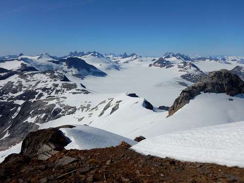
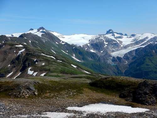
Nugget Mountain provides a stunning view of the Juneau Icefield and a dramatic transition into the glaciated alpine environment from the coastal forests of lower elevation. Lemmon and Ptarmigan glacier as well as the valley lakes are visible as well as Split Thumb, Amherst, Spencer, and the Mendenhall Towers.
Getting There
The hike starts from the same location as the well-known hike to Thunder Mountain.
The trailhead begins at the end of Jennifer Drive behind Glacier Valley Elementary School. Follow boardwalk over swampy terrain until it intersects a dirt trail. Take a right here and the Thunder Mountain trail turns left and up just after a small stream. This trail climbs very steeply in the beginning.
Another option is to climb from Blackerby Ridge and go via Camp 17. It's a longer route and involves traversing the Lemmon Glacier. I have included the route in the map and as part of the .gpx file located on this page.
Route Description
The Nugget Mountain Route starts from the well known Thunder Mountain Trail. Follow boardwalk over swampy terrain until it intersects a dirt trail. Take a right here and the Thunder Mountain trail turns left and up just after a small stream. This trail climbs very steeply in the beginning and after 1.25 miles intersects a lesser known (and very muddy) trail that comes up from Lemmon Creek. Just remember the intersection when you're coming down the trail delerious from hiking 20+ miles. After 2.3 miles the trail ends up on the top of the Thunder Mountain Ridge.

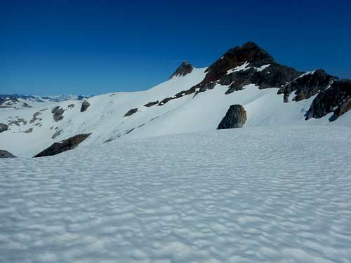
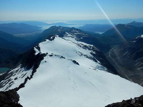
From here follow the user trail on climber’s right and follow the ridge for 8ish miles. At mile 2.8 you'll encounter very steep rocks. Hang on climbers Left and follow the user trail and climb up the rope that’s tied to a tree. At mile 5 all sense of a user trail will disappear and you will be left to route find the least obtrusive way down the ridge. The view up the ridge will look like the photo below and you're roughly halfway there
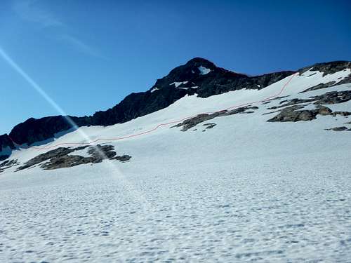
After 8ish miles of the ridge (total miles of 10.2) steeply downclimb on climbers right onto the snow and traverse below the summit to the opposing ridge to avoid cliffs. There isn't really a best time to descend off Heintzelman, but getting near where the ridge cliffs out and finding anywhy down is a good choice.
The traverse is pretty slide sloped so if the snow is hard, crampons and ice axe will be necessary. Photo below shows the traverse and roughly the place to start the traverse from the ridge highlighted in Red
Access the opposite ridge by finding a break in the cliff line and hike straight towards the summit. I stuck to climbers Left and avoided the snow with a bit of class 3 scrambling. Finally at mile11.35, you're there!
From here turn around and hike all the way back to round out your 22.7 miles day, or hike across an unnamed snowfield and then the Lemmon Glacier to reach Camp 17. This is occupied in early summer by JIRP, but generally has a place to crash. At mile 19 for the day you'll arrive at Camp 17 and continue the next day to the Blackerby Trailhead for a total of 25.2 miles.
See attached .gpx for an exact route or check out the Juneau Hikes and Summits CalTopo page.
Essential Gear
Ice axe and crampons as well as a long days worth of food. In addition dress appropriately. Mountaineering boots or stiff waterproof boots are necessary and gators help keep your socks dry. Having a SPOT or InReach is a great idea. Bring extra dry/warm stuff.