Trip Report
![The Brothers Wilderness]() Brothers Wilderness
Brothers Wilderness "I Am a Man of Constant Sorrow…For in this world I'm bound to ramble," lyrics from the soundtrack to the film
O Brother, Where Art Thou? were running through my head as I, delirious with exhaustion, stumbled down the dark trail frequently tripping over roots and rocks. My three teammates and I were trailhead bound after completing our climb across the Brothers Traverse. It was well past midnight and our way was illuminated only by headlamps in the moonless night. The weight of my backpack dug painfully into my shoulders and my feet ached with every step. We finally stopped for a quick break, unshouldering our packs at the viewpoint above Lena Lake. The mantle of stars in the cloudless night sky glittered reflected light across the lake's dark, still waters. It was the weather we were promised by the forecast, unfortunately it arrived too late—it was 1:30am. We could have used clear skies about sixteen hours earlier when we reached the North Brothers summit. It would have saved us a lot of time in a day that started at 5am. When we rested at Lena Lake we were twenty-and-a-half hours into a day of non-stop climbing and hiking and still one-and-a-half hours away from the trailhead. That said, I had no right to complain. I was a student in the 2013 Boeing Employees' Alpine Society Intermediate Climbing Class (BOEALPS ICC) and I had requested The Brothers Traverse as my first alpine climb.
Holy Crap! A twenty-two hour summit day! This was the ICC of legend. Prior to signing up for the class I heard a lot of crazy stories about the ICC and how hard-core it was. The year before I was a 1st year instructor with the 2012 BOEALPS Basic Climbing Class (BCC). From the Senior and Lead BCC instructors I heard tales of brutal weekend-long ICC climbs that would stretch into Monday morning (graduating from the ICC is a prerequisite for Senior and Lead BCC instructors). The ICC was also a big commitment that spanned the entire spring and summer. At eleven full weekends every other weekend from March through August it was a veritable mountaineering class odyssey. The first five weekends were skills weekends: Horsethief Butte (rope work), Stevens Pass (snow), Leavenworth (rescue), Smith Rock (multi-pitch), Squamish (trad leading). Following the skills weekends the alpine climbs started (with one more skills weekend before the Graduation Climb): Alpine Experience Climbs One to Four, Mount Baker (ice climbing), and the Graduation Climb. The first five skills weekends were way more chill than I was expecting, and I was not complaining. Then Alpine One happened. The Alpine Experience Climbs were where the class really kicked it into high gear.
![The Brothers from Seattle]() The Brothers from Seattle
The Brothers from Seattle The Brothers Traverse climb began on the Seattle waterfront early Saturday morning. We were waiting for the first ferry to Bremerton at 6am. It was the beginning of June so it was already light out and we had a good view of the Olympic Mountains. Nearly due west of Seattle, the twin peaks of The Brothers stood out prominently in the range of peaks running along the eastern edge of the Olympics that includes other summits like Mounts Ellinor and Constance. As the crow flies it is only about thirty miles to The Brothers trail head, but the waters of the Puget Sound separate Seattle from the Olympics. Although travelling via ferry is most direct route, it was actually slower than driving the whole way round through Olympia. During our trip planning the ferry route won out because it had the advantage that we could have coffee and breakfast on the ferry while discussing our climb plan.
![Trip planning en route to The Brothers]() Climb planning on ferry
Climb planning on ferry
The previous five skill outings involved the whole class of 30+ students and instructors, but for the Alpine series climbs the class breaks up into climbing teams of four: two instructors and two students, sort of like Army fireteams. Brian and Brandon were our instructors and Steve was the other student. BOEALPS is an all-volunteer organization and it is part of the club's culture that students usually return the next year to instruct. It was Brian's third year instructing while it was Brandon's first. It was also one of Brandon's last chances to climb for a while because at that time his wife was seven months pregnant with their first child.
After the ferry we drove down the Kitsap Peninsula to Shelton where we turned north on Highway 101, which runs up the Olympic Peninsula along Hood Canal. It was a scenic drive, mist was rising off the waters of the Hood Canal and looking east we could see the peaks of the Cascades in the distance. I was looking forward to the approach hike; it had been over a dozen years since I last hiked the trail to The Brothers. In the spring of 2000 I attempted The Brothers' South Summit with some friends. Although the North Brothers summit and the Traverse are challenging and only see a few climbing parties every year, the Brother's South Summit is a very popular scramble that attracts climbers of all levels of ability. However it was early spring and we were totally unprepared for the conditions. The closer we got to the South Summit the deeper the snow until we finally decided to turn around. I was not disappointed; the eight-mile approach hike along the Lena Lake trail and through the Valley of the Silent Men was great hiking. About halfway up the trail in the Valley of the Silent Men there is an amazing waterfall grotto, like something out of a painting. For years I had a photo of that waterfall pinned to the bulletin board next to my desk, a reminder to return someday. When I heard that it was an option for my Alpine One climb I jumped at the opportunity. Fortunately in 2013 the scenery had not changed much. It was still the same classic Olympic Peninsula hiking through lush old-growth rainforest that I remembered.
The Brothers along with two other peaks visible from Seattle owe their names to a young bachelor whose research vessel was anchored off the coast of West Seattle in the middle of the Nineteenth Century. In 1857 George Davidson was in command of a brig exploring the waters of the Puget Sound for the U.S. Coast Survey. He was engaged to Ellinor Fauntleroy and with thoughts of his fiancée in mind he christened one of the peaks of the Olympics in her honor (they were married a year later). The rest of the Fauntleroy clan were placed on the map too. Mount Constance was named for Ellinor's sister and The Brothers were named for her siblings Arthur and Edward. Seattle's Fauntleroy neighborhood takes its name from the cove where Davidson anchored his brig and which he named in honor of his bride-to-be's father. Back in those days of blank maps you could get in good with your future in-laws on the cheap.
![The Valley of Silent Men]() Valley of Silent Men
Valley of Silent Men | ![Brothers Approach Hike]() Lena Creek East Fork
Lena Creek East Fork | ![Waterfall Grotto, The Brothers trail]() Waterfall Grotto
Waterfall Grotto | ![Storm damaged log bridge]() Damaged Bridge
Damaged Bridge |
The approach hike was uneventful and we were able to establish our camp by about 4:30pm. We set up our camp high in the vicinity of the "Lunch Rock". The main campsite for Brothers climbers is lower down, but we wanted to camp high to save time on summit day. We knew there was a good campsite in that area, but we were unable to locate it. We improvised our own by digging out narrow platforms in the steep snow for our bivy sacks. A bivy sack is like a tiny tent only slightly larger than your sleeping bag. Some people swear by them, but I still have yet to warm to bivy sacks—sleeping in one is claustrophobic and they get damp with condensation. That said, they have an important role in alpine climbing. Compared to tents, bivy sacks are light and require very little space to set-up.
I was worried we were goingto have too much time to kill Saturday afternoon, but after setting up camp we immediately took off to scout the approach route to the Great Basin—our route the next morning to the North Brother.
The Great Basin is the east face of the Brothers. It's the big snowfield draped between the two summits visible from Seattle. Finding a route proved a lot tougher than I would have guessed so it was a good thing we took the time. A band of fortress like cliffs walled off the approach to the North Brother, so it took some serious route finding to locate a passage through. Low-lying clouds enveloping the mountain compounded the difficulty of our reconnaissance. Visibility was limited making it tough to see and there was a lot of second-guessing on our part. We were not able to establish an approach route until about 8pm after which we return to camp to get some sleep. It was worth the trouble because it saved us valuable time on our summit day. I hoped to get to sleep no later than 8pm, but it was closer to 10pm by the time I crawled into my bivy sack to get some shut-eye.
![Heading up to the Lunch Rock]() Near The Brothers
Near The Brothers | ![Searching for route to The Brothers Great Basin]() Route finding
Route finding | ![View from SE arm of The Brothers]() View from Brothers' SE arm
View from Brothers' SE arm | ![Bivy sack camping]() Bivy sack camping
Bivy sack camping |
I was up at 4:15am and we were moving at 5:05am. Once we made the passage through to the Great Basin it was a little annoying to see we saw that one of our original ideas about how to get through was correct and that there was a shorter route than the one we took. It could not have been helped though, in the fog the day before there had been no way to confirm which route was going to be the shortest and safest. So the route we picked was the best one based on the information we had at the time. Once through, getting to the North Brother was a relatively direct snow slog and we were on the North summit by 8:45am. We were close to our original schedule so it looked like everything was going according to plan. I thought the traverse would be straightforward. I was not expecting a long or difficult climb. I thought the toughest part would be the eight-mile approach hike. One of the reasons for selecting the Brothers for my first alpine climb is I thought it would be a good "shake out" climb to test gear and the climbing techniques I had learned during the skills outings before tackling more challenging climbs later in the class.
![The Great Basin (The Brothers East Face)]() Great Basin
Great Basin | ![The Brothers North Summit]() North Brother
North Brother | ![Summit Register at the Brothers North Summit]() Summit Register
Summit Register |
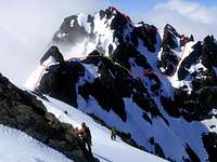
In our planning we decided that once on the North summit we would make our traverse go/no-go decision. If the weather looked like it was improving we would go for it. If not we would turn around and retrace our steps back to camp. The Brothers Traverse is what is called a "committing" climb because once started it would be difficult to bail out and we would have to see it through. At that time the clouds appeared to be lifting, as the forecast predicted, giving us a clear view of the South Summit. It is only about a third of a mile across the Traverse and it looked straightforward so our plans to be on the South Brother by 3pm appeared doable and in fact even conservative. Unfortunately that was the last time we would see the South Summit until we were standing on it. Once we committed to the traverse the clouds closed in again and our plans went pear-shaped. I learned this is what in sailing is called a "sucker hole", a brief break in the weather that fools people into taking risks where bad weather will be a problem. We would spend the next twelve hours navigating through thick fog looking for the South Brother.
![Our route across The Brothers Traverse]() Traverse Route
Traverse Route By our original timeline we should have been back to the car early enough to get dinner and beers on the way home. Since we did not know exactly when we would get back to the trailhead we were not counting on catching the ferry and instead planned to drive home the long way via Olympia. Fish Brewing runs a good brewpub in downtown Olympia right next to their brewery. I know the Fishbowl pub well because whenever I mountain bike in Olympia's Capitol Forest I always stop off there afterwards. Visions of a pint of Fish Tale ale dangled in front of me like the metaphorical carrot from a stick as we started the traverse, but as clouds closed back in and as the day dragged on the prospect of a beer receded further and further away into the mist.
![Looking for the other Brother]() O Brother?
O Brother?I knew the traverse was going to be challenging, but I never would have guessed it would be nearly twelve hours before we would find ourselves on the South Summit. Our most conservative estimate for the traverse was seven hours.
We were enveloped in clouds, which made the route finding tough. None of the climbing was particularly difficult, but it was often very exposed so we had to set pro as we went. We were frequently traversing knife-edge ridges with sheer drops of hundreds of feet to either side. It was difficult to find places to set pro. The crumbly rock of the Olympics is notoriously bad for climbing, so we often had to rely on slings and snow pickets. What really ate up the hours though was that we had to keep stopping to navigate in the thick fog. We constantly halted to regroup and to consult our maps and compasses, second-guessing the route as we wondered if the light and dark smudges visible through the fog were the features we were looking for.
The final challenge before we could start ascending to the South Summit was a steep snow traverse. In a trip report written by another BOEALPS group a few year earlier they described this as the "sketchtastic" traverse. It was an apt title. If anyone fell there was only a short run out to arrest your slide before tumbling over a cliff. The rock was crap so we could not find a single place to set rock pro. So for a full rope length we only had two pickets lodged in the thin snow for protection. I am not sure how much they would have done for us had someone fallen, the benefit was mostly psychological. Fortunately we all made it without a hitch, but I know my heart was racing when I was halfway across and it was a big relief to put the "sketchtastic traverse" behind us.
![Sketchtastic Traverse]() Sketchtastic Traverse
Sketchtastic Traverse By the time we reached the South Brother it was 8:30pm—very late. We almost did not make it to the second summit, but Steve pushed us to keep going. I was glad, it did not cost us much time and it would have been a big disappointment to spend so much time on the climb and not bag both peaks. From there it was a quick hike back to camp, but we still faced the eight-mile hike back to the car. It was a long brutal hike, one of my worst post-climb hikes out ever. With the benefit of hindsight I realized that I was not eating enough and not enough of the right stuff. I remember distinctly that right around 9:30pm I suddenly felt light headed and very weak. I had "bonked", my blood sugar levels had dropped due to not eating enough to keep up with the strenuous climbing and hiking. I had to borrow a trekking pole from Brandon to help keep my balance.
![Brothers South Summit]() Brothers South Summit
Brothers South Summit If it was up to me we would have slept at one of the campsites on the trail and hiked out in the morning, but the guys were all hard-core hiking machines and wanted to get back so they could go to work Monday morning. We did not reach the car until 3am. We drove straight back to Seattle and made it back to the Greenlake Park & Ride at 6am. I clearly was not in good enough shape for alpine climbing. I do not know how those guys managed to go to work after that, I called in sick and slept until the late afternoon. The Brothers totally kicked my ass and it was only the first of the Alpine series climbs, there were still three more and then the grad climb too! I was right, the Brothers Traverse was a good shake out climb and I learned a lot…the hard way. Brandon summed it up well, "I agree that the climb was long and tiring, but climber's amnesia will put it in place as a great route."
Timeline & Route Map
| Planned Timeline |
| Saturday |
| 6 am | — | Leave Seattle by ferry |
| 9:30 am | — | Leave trailhead |
| 5 pm | — | Get to high camp |
| 7 pm | — | Scout the route |
| |
| Sunday |
| 5 am | — | Wake Up |
| 5:30 am | — | Start climb |
| 8 am | — | Reach North Peak |
| Noon | — | Complete traverse |
| 2 pm | — | Breakdown camp |
| 7 pm | — | Get to car |
| 8:30 pm | — | Dinner in Olympia |
| Actual Timeline |
| Saturday, June 1st, 2013 |
| 5:20am | — | Meet at Park & Ride |
| 6am | — | Ferry |
| 8:30 | — | Trailhead |
| 9:15 | — | Hiking |
| 12:30pm? | — | Climbers camp at 3kft |
| 3pm? | — | Lunch Rocks |
| 4 or 4:30pm? | — | making camp at 5600ft |
| 5:00pm | — | notch hunting |
| 8:00pm | — | notch found and group reunited |
| 8:30pm | — | camp |
| 10pm | — | bed |
| |
| Sunday, June 2nd, 2013 |
| 4:30am | — | wake |
| 5:00am | — | hiking |
| 6:00am? | — | top o' the notch |
| 8:00am | — | top of couloir near N Summit |
| 9:15am | — | start the traverse shenanigans |
| 7:30pm | — | top of couloir near S Summit |
| 8:00pm | — | S Summit |
| 8:30pm | — | back at camp |
| 9:15pm | — | leaving camp |
| |
| Monday, June 3rd, 2013 |
| 3:00am | — | trailhead/car |
| 6:00am | — | Greenlake Park & Ride |
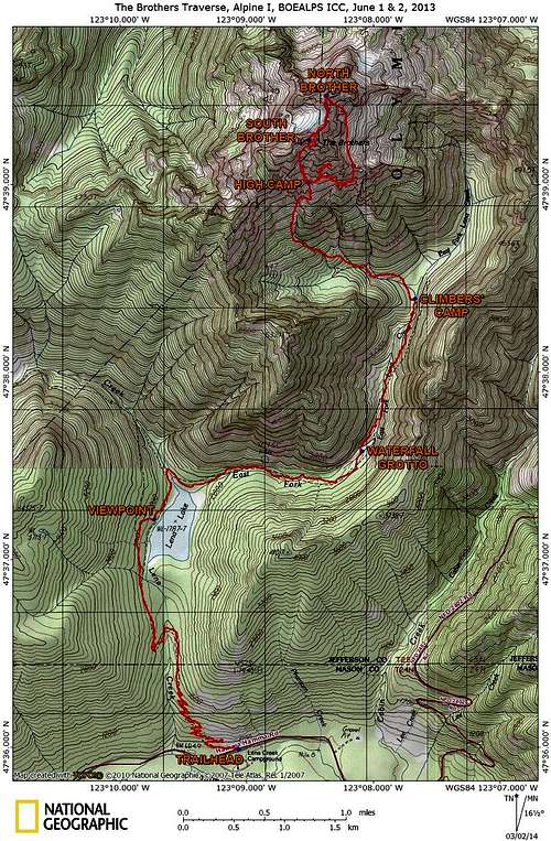
![The Brothers Traverse Route]() The Brothers Traverse Route Map
The Brothers Traverse Route MapLinks
The Brothers Traverse Trip Report, June, 2009
www.mountainproject.com/v/brothers-traverse/106494582
Brothers Traverse- SE Ridge to S. Brother to N. Brother via traverse 4/11/2004
cascadeclimbers.com/forum/ubbthreads.php?ubb=showflat&Number=335153
The Fish Tale Brew Pub (Olympia, WA)
www.fishbrewing.com/brewpub/
Boeing Employees Alpine Society (BOEALPS)
www.boealps.org
References
Morse, Roy W., Brown, Richard, E.
Fauntleroy Legacy. Seattle : Self-published by Morse and Brown, 1989.
Washington Historical Quarterly 4 (3): 182–86.
Retrieved 2011-01-05.
journals.lib.washington.edu/index.php/WHQ/article/viewFile/5032/4109
(Cited by the Wikipedia entry for The Brothers)
Olympic Mountain Rescue (Society).
The Olympic Mountains: A climbing guide : alpine climbs, rock climbs, and high traverses (4th ed.). Seattle. WA :, Mountaineers Books,, 2006
Smoot, Jeff.
Climbing Washington's Mountains : summit hikes, scrambles, and climbs in Washington's Cascade and Olympic Mountain Range. Guilford Conn.: Falcon, 2002. Pgs. 369-372.
Green Trails Maps.
The Brothers, Map No. 168. 1:69,500. Seattle, WA:
www.greentrailsmaps.com, Original Ed. 1975, Latest Revision 2003.
Comments
No comments posted yet.