
|
|
Mountain/Rock |
|---|---|
|
|
39.70910°N / 106.312°W |
|
|
Summer, Fall |
|
|
12692 ft / 3869 m |
|
|
Page is best viewed at monitor resolution of 1024x768
Gore Range Overview
”In my opinion, the two most rugged mountain ranges in Colorado are the Gore Range northwest of Dillon Reservoir and the Needles Range in the remote San Juan Mountains.” -John Fielder-famous Colorado Landscape photographer.
The Gores are more of a range consisting of 12-13,000-ft ridges, rather than separated peaks. A few of the more prominent ridges actually have names like, Zodiac Spires, Rockinghorse Ridge, Ripsaw Ridge and the Grand Traverse. With 50 peaks over 12,000-ft, none attain the magic 14,000-ft mark, which is the primary reason for the Gores obscurity. This is one of Colorado’ most rugged mountain ranges and the rock quality is generally good.
Only 60 miles from Denver, Colorado the Gore Range as a whole is relatively inaccessible due to the lack of mining roads that normally criss-cross other Colorado mountain ranges. The Gores also have a reputation for a lot of trailhead access red tape, due in large part to private property. Hikers and climbers not interested in long approaches and heavy vertical might want to look elsewhere for their adventure. Overall, the west side of the Gore Range is more accessible than the east. Approaches that start from the east are few because of private property, in return, expect even longer approaches and expect a poor network of trail systems. Precise planning and execution are of paramount importance when selecting routes in this range. Armed with a loaded backpack and good maps, many of these quiet summits can be climbed without a rope. Major faces and long jagged ridges provide unlimited technical climbing opportunities as well. An ice axe is highly recommended on any early season climbs.
Officially named peaks in the Gore Range are hard to come by, only a few of the Gore highpoints have official names. Differentiating the highpoints on a map or while hiking has challenged all of us at some point. Thankfully we have the CMC to make sense of all of that rugged terrain. In 1932, CMC members Carl Erickson and Edmund Cooper used letters to assign summits in the obscure Black Creek Basin and the CMC subsequently tended and expanded the system (Jacobs & Ormes- Guide to Colorado Mountains.) The lettering system for naming peaks has frustrated many casual visitors over the years, however Gore Range enthusiasts, or "Gore-cores" seem to embrace the system.
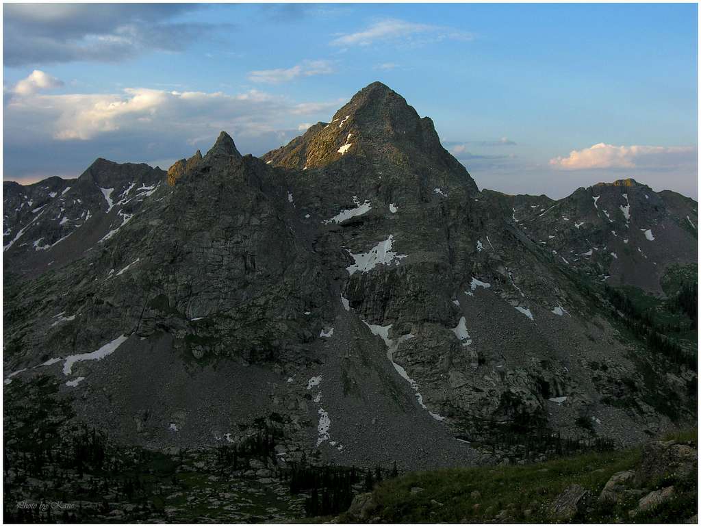
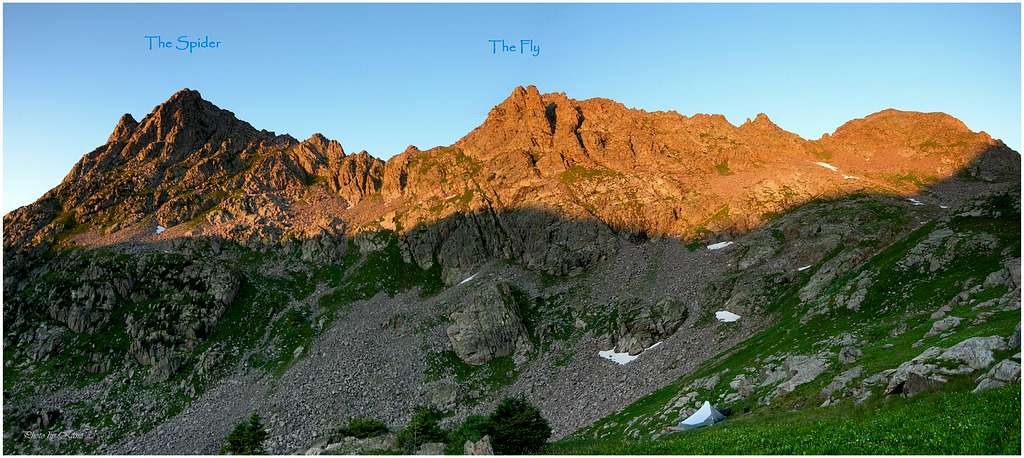
The Spider & The Fly Overview
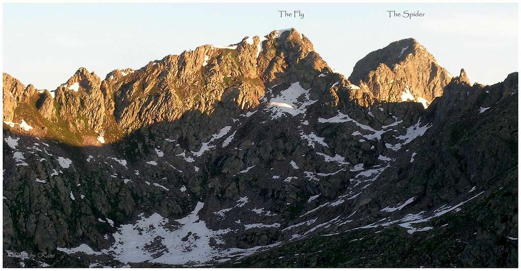
The Spider and The Fly are two unofficially named twelvers residing on a rugged spur ridge west of the main spine of the central Gores. The Spider (12,692-ft) is officially ranked and The Fly (12,550-ft) is not. From the rugged Booth Lake area, The Fly dominates the view while its parent peak The Spider hides behind its siblings shadow, out of view from lake visitors. Instead, The Spider has its own domain, soaring 3,000-ft above the pristine upper Piney Lake Valley overlooking what has to be one of the best 360 views in the entire Gore Range.
Both summits reside so close to one another it’s easy to consider them a singular mountain. In the end, both inherit their own character mostly because of a spectacular, serrated ridge that splits the two suspended summits. This connecting ridge is the south ridge of The Spider and its one fantastic route for attaining the secluded watchtower-like summit. Overall, The Spider proves the better peak of the two. However when combined, the two play off one another in a way that other nearby peaks have trouble emulating. The rock is bomber and the views are nonstop.
The area encompassing these two obscure gems easily qualifies as some of the tip top most scenic terrain to be found in the entire Gore Range. Beyond the Upper Piney Valley resides the main spine of the central Gores, which harbors many ranked thirteeners and the longest most rugged run of ridge in the entire range. Appropriately named sections of ridge include, Ripsaw Ridge (Peaks C, D, E, F, G, H,) The Saw, and Rockinghorse Ridge (Peaks J & P.) Capping off the very end of the ridge is the great West Partner Peak.
Booth Lake Trailhead
The Spider and The Fly are best accessed from the Booth Creek Trailhead. Take I-70 to Exit 180 or the East exit in Vail. Turn left and drive about 1 mile to a signed turnoff next to a bus stop. Turn right and drive about 100 yards to a nice parking areaEagles Nest Wilderness-Red Tape
Red tape- courtesy of ATTMNo permits or fees are required. There is a climbers and hikers parking lot just before entering into the Piney Creek Ranch. There should be plenty of room to park.
Like all wilderness areas no mechanized or motorized vehicles are permitted within the Eagles Nest boundaries.
For more information, contact the U.S. Forest Service at the # below:
USDA Forest Service
White River
National Forest
900 Grand Ave.
P.O. Box 948
Glenwood Springs CO 81602
970-945-2521
White River National Forest Home Page
Additional Resources:
Western Portion of the Wilderness:
Holy Cross Ranger District
P.O. Box 190, 24747 US HWY 24
Minturn, CO, 81645, Phone: 970-827-5715
or
Eastern Portion of the Wilderness:
Dillon Ranger District
680 River Parkway
Silverthorne, CO 80498
970-468-5400
Information on avalanche conditions:
Colorado Avalanche Information Center
Current fire restrictions:
Colorado Office of Emergency Management: