
-
 7186 Hits
-
 93.81% Score
-
 44 Votes
|
|
Mountain/Rock |
|---|---|
|
|
49.15488°N / 20.02207°E |
|
|
Hiking, Mountaineering, Sport Climbing, Big Wall, Scrambling |
|
|
Spring, Summer, Fall, Winter |
|
|
6985 ft / 2129 m |
|
|
News on the page
11th september 2006: added Routes section. Added routes from west side and the nicest route from the more interesting east wall.10th february 2008: some additions to Routes section. Route page Gronski, Kecer, Zdiarsky was also improved.
Overview
Names: Ostrá veža (sk), Wazeckia turnia (pl), Osztra-torony (hun), Ostraturm (ger), Sharp tower (en).
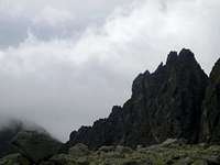
![mystic Ostra veza]() Is Ostrá veža Saint or demonic? I prefer the first. Anyway it´s mystic - and attractive.
Is Ostrá veža Saint or demonic? I prefer the first. Anyway it´s mystic - and attractive.
The name Ostrá veža comes out of two reasons. One is the shape of towers - toothy like, wild ridge and the second reason is its position in the south ridge of Ostrá (Mount Sharpy). The former polish name Ostra turnia was more in harmony with slovak name and its derivates - hungarian and german name. Alfréd Grósz tried (in his 1961's book Die Hohe Tatra) to germanise its name to Scharfkammturm, but it wasn't widely accepted.
![Ostra veza (2129 m) with Sedielkovy priechod saddle under windstorm]() Ostrá veža how it truly is - scary and magnificent.
Ostrá veža how it truly is - scary and magnificent.
Massif of twin peaked Ostrá veža is an adorable, but neglected part of High Tatras range in Slovakia. Its really sharp rocky towers do not offer easy access to the top. When trying to summit it, have always in mind that fact. There are plenty beautiful, but much more easy and safe summits in Tatras, as well as all over the world.
Despite it is one of the lower summits of crotch - south ridge - of Ostra (2350 m), it is far more arduously accessible. Its walls are up to 180 meters high and have climbing routes up to the grade UIAA V+ (until 1989; later climbers may have created even harder routes). There are no glaciers today in Tatras, so one can have here a good pure rock climb. Another advantage is its position. It is easily approachable from resort Strbske pleso in 2 hours time and from chalet under Solisko only half hour is needed to get under the peak. Its position makes it adorable from one more reason: when looking towards dominant Krivan from chalet under Solisko, Krivan is flanged by its sharp towers on the right and by patulous and grassy Sedielkova kopa on the left and (when looking from chalet under Solisko) Krivan seems to be towering just above the saddle that connects Sedielkova kopa with Ostrá veža. Anybody having seen this view, must have fallen in love with both Krivan and Ostrá veža. These feelings comes even stronger to the Ostra veza when you leave the chalet, following blue marked hiking trail towards and slightly down to the Furkotska valley. That is because, as you slightly descend and get closer to the nearest ridge - crotch of Ostra (and especially its part between nearest Sedielkova kopa and Ostrá veža) - Krivan hide itself behind that ridge. All the magnificence Krivan enriched you, you desire to dedicate to the most adorable object that you see right know. And in such a moment that object definitely is the Ostrá veža massif.
![panorama of Furkotska valley]() Sedielkova kopa on the left, Krivan in the back and Ostrá veža on the right
Sedielkova kopa on the left, Krivan in the back and Ostrá veža on the right
It is the part of the S-N ridge - south crotch of Ostra (2350 m). The neighbour of Ostra veza and the last monticule in the crotch of Ostra is Sedielkova kopa (2061 m). As a part of south ridge of Ostra, Ostra veza is towering above two valleys - to the east there is Furkotska valley and to the west there is valley dolina Suchej vody. As for neighbouring Sedielkova kopa, here also rules the same national park restrictions. More info you will find in the Red tape section.
![Ostra veza from west]() Ostrá veža in the centre, Solisko ridge behind.
Ostrá veža in the centre, Solisko ridge behind.
The first to be on the summit were Alfred Martin and guide Johann Franz on 19th september 1907 during the climb of the whole crotch of Ostra. In winter was here first Alfréd Grósz and Gizella Schmidtová on 27th april 1913 also when climbing the crotch of Ostra.Massif maps and picture description
For seeing map presenting hiking trails to approach Ostrá veža see external map linked from Getting there section and Sedielkova kopa page, also Getting there section.
Ostra veza is not a simple summit. It has two main summits - south and north and its massif include some more little towers. Let's get overview of them! Here you see the most possible description of the Ostrá veža summit and its surroundings. Massif of Ostrá veža itself consists of (numbers are related to the picture):
11 - Vysny ostry zarez - (The upper sharp aperture) it's the down edge of the Ostrá veža massif itself
(12 - 20 = massif of Ostrá veža itself)
12 - Ostry hrb south summit (Sharp hump)
13 - Strbina v Ostrom hrbe (aperture in Sharp hump)
14 - Ostry hrb north summit (Sharp hump)
15 - Nizna ostra strbina (The lower sharp aperture)
16 - Ostry palec (Sharp finger)
17 - Prostredna ostra strbina (The middle sharp aperture)
18 - Ostrá veža south summit
19 - Ostra strbina (Sharp aperture)
20 - Ostrá veža north summit
21 - Ostry zarez - upper edge of the Ostrá veža massif. (Sharp cut)
According to the climbers' bookguide this whole part of ridge is III grade UIAA route.
![Massif of Ostra veza]() overview and the most detailed description of Ostrá veža massif (numbers 12-20) from east. The eastern walls are 150-180 meters high.
overview and the most detailed description of Ostrá veža massif (numbers 12-20) from east. The eastern walls are 150-180 meters high.
![Ostra veza from west - description]() overview and description of massif of Ostrá veža (numbers 10-14) from west
overview and description of massif of Ostrá veža (numbers 10-14) from west
![map of ridges with hiking routes]() map - diagram of ridges with drawed marked hiking trails.
map - diagram of ridges with drawed marked hiking trails.
![map of Ostra veza and its surroundings]() map of Ostrá veža with its surroundings
map of Ostrá veža with its surroundingsRoutes
Ridges routes
![Ostrá veža (2129 m) south ridge]() south ridge
south ridge
Ostrá veža has a south ridge and a north ridge, continuing in higher monticules, that are not that sharp as Ostrá veža. The ridge is of IInd grade UIAA (new classification by climbers; climbing book guide by Puškáš from 1988 says it's of IIIrd grade).
Routes from west side
Ostrá veža is the only summit in the crotch of Ostra (2350 m) that has the west wall, from the valley dolina Suchej vody. Other objects in that ridge have only west slopes.
1. Traverse in west walls. II-III grade UIAA. Stanislaw Gronski, 26th july 1943. The summit walls can be traversed from the side of the valley dolina Suchej vody - from saddle Vysny ostry zarez to the saddle Ostra strbina between the two summits. Then ascend one north or south summit.
2. To the Ostrá štrbina. I grade UIAA. Stanislaw Gronski, 26th july 1943. Its part is a way how to get under the wall, so its essential to see the page for all other west wall routes. It is a usual descend route.
3. By the rib to the north summit. II-III grade UIAA. 1 hour wall ascent itself. Eva Hutlakova - Milan Hutlak. july 1983. From the half of the couloir that falls from the saddle Ostry zarez, traverse to the right to non-dominant rib, that will get steeper after the second pitch. Follow steep catwalks slightly towadrs the left to the north summit of Ostrá veža.
4. Variant of the previous to the south summit. II-III grade UIAA. 1 hour wall ascent. Eva Hutlakova - Milan Hutlak. july 1983. From the north summit rib, at its half, turn right. Traverse the couloir falling from saddle Ostra strbina (between N and S summits), and after 3 pitches ascend by steep plates to the south summit.
5. By the left couloir to the north summit. II grade UIAA. 45 minutes wall ascent. Martin Busovsky, Eva Hutlakova, Milan Hutlak, 20th july 1982. The start is practically from the couloir of the saddle Ostry zarez. At the half of the couloir go right throgh plates covered with scree. In the middle there is steep rocky rib. Go up left of it. You enter the scree cauldron, under the summit wall. The wall on the left has a steep and narrow couloirThrough it to the ridge 8 meters and more 15 meters by the ridge to the summit. Usable also for descend.
Routes from east side

The east wall is from 150 to 180 meters high. For better orientation see this photo and its caption. It wides the entire space between Ostry zarez and Vysny Ostry zarez. From right it is bordered by significant pillar that leads to the south summit. Pillar is bordered by the couloir that falls from the saddle Ostry zarez. The wall in its under-summit partcuts a catwalk, short that leads from the half of the pillar up to the saddle Prostredna ostra strbina. It is the upper catwalk. The lower catwalk cuts the whole massif from the bottom of the wall. It leads from the south pillar up right and ends on the south ridge of the Ostrá veža under the south summit of Ostry hrb. From left to the right cuts the massif as well as two mentioned catwalks steep, not solid and grassy couloir that starts in the catwalk under the Vysny ostry zarez and leads to the saddle between the S and N summit of Ostrá veža. The first to touch this wall was Stefan Zamkovsky with Zoltan Brull in summer 1933.
Total 13 routes:
1. Zamkovsky's route, by the wall to the north summit. IV grade UIAA. 2´30 hours wall ascent. Zoltan Brull, K. Matherny, Stefan Zamkovsky. 24th july 1933. In winter Miroslav Grois, Miroslava Groisova, 21st april 1962. The most famous, most popular and most recommended route of Ostrá veža. From the couloir falling from Ostry zarez, towards left to the wall of the pillar and through it by steep extents 25 meters up under the great overhang. From there askew by plates right under the 8 meters high wall and through it to the exposed pillar up of its first steepness. It is possible to get there variantly directly from the couloir of the saddle Ostry zarez. By the pillar up, left of its highest exposure, go right around overhang, to the 5 meters long chimney, that is in its upper part overhanging. Through the chimney to the grassy balcony. From there 40 meters towards left, from where you enter the east wall of Ostra veza itself by upper grassy catwalk under small grassy chimney. Through it up. Then through 4 meters high wall and through steep plates, from where to the small couloir very near of pillar. On the pillar through chimney that leads to the another chimney and by it 10 meters to the north summit of Ostrá veža. Getting There
Ostrá veža is the neighbouring summit to the Sedielkova kopa, so access routes ake very similar. When not in Slovakia or Poland, you have to get to Bratislava, then get to Poprad (680 m) - slovak most important mountain resort. You may do it by plane, bus, train or car. From there another 20 kilimetres to resort Strbske Pleso (1355 m). You may use train, bus or your car. Whole day-parking costs in Strbske Pleso about 160 slovak crowns. Transport routes in slovak parts of Tatras are here. Bus and train connections are here.
![The most majestic Ostra veza]() The place on the trail, from where Ostrá veža is the most impressive.
The place on the trail, from where Ostrá veža is the most impressive.
Similarily as for approach to Sedielkova kopa you´ve got two possibilities to approach Ostrá veža from Strbske pleso (1355 m):
1. follow the red marked trail forwarding to the Jamske pleso. After 30 minutes of walk you come to junction. There you have to turn right and follow the yellow marked trail. After another 30 minutes of ascending the valley Furkotska dolina you come to another junction. Here comes the short blue hiking marked trail from chalet under Solisko (15 minutes). Do still follow the yellow trail - you have Ostrá veža on the front left, scarily towering above the valley. Another 20 minutes of walk-up, and when you turn left, you are just in front of eastern wall of Ostrá veža.
2. from Strbske Pleso follow blue marked hiking trail to the chalet under Solisko (1830 m) or take a lift to the chalet for 130 slovak crowns = 4-5 euro. Walk-up will take 90 minutes, lift only 7 minutes. From chalet continue following blue marked trail - go west off the chalet - towards Krivan and Ostrá veža. You lightly descend to the elevation of 1715 meters in 10 minutes time. From here the two routes go the same direction - up the valley following yellow marked trail 20 more minutes. Both accessibility possibilities you see at this linked map.
Both possibilities have its pros and cons. When going from chalet under Solisko, you see also Krivan (unless it is hidden in clouds), which adds a portion of admire and exaltation of mountains. On the other hand, you see Ostrá veža only from the chalet under Solisko. So when approaching from the bottom of valley Furkotska dolina, you are concentrated only on your goal - Ostra veza and you see it much more time than from the chalet route.
Ostrá veža is often climbed from E, where both described trails lead us. Some climbers do it their way, they go more left - not directly under the wall, but to the soft and wide saddle Sedielkovy priechod, where they start their climb of south crotch of Ostra - and of course their climb of Ostrá veža.Red Tape
As for Sedielkova kopa, here also rules the same national park restrictions. This means that access from east valley - valley Furkotska dolina - to the top is for climbers unrestricted on condition they do not harm nature and climb route of at least III grade UIAA. Hikers are allowed to go there from this side when hiring a mountain guide (it costs at approximate 100-200 euro a day). After all, no hikable trail leads to the summit from this side. To make things more complicated, on the other side of Ostrá veža, in valley dolina Suchej vody - there is strict nature reserve, where noone except from scientists and national park rangers is allowed to go. The border between strict reserve and less protected area is the south ridge of Ostra. You see it also on this map. White areas within magenta dashed lines are strict reserves. The magenta dashed line follows directly the crotch of Ostra, and thus forbides any mountaineering activity on objects in Ostra's crotch from west.
![Krivan from chalet pod Soliskom]() Also availability of hiking trails is limited - most of them are usable yearly only from 15th june till 31th october.
Also availability of hiking trails is limited - most of them are usable yearly only from 15th june till 31th october.
If any non-climbers desires to stand on the summit of Ostrá veža, technically there is one possibility - through one canal in west wall - following route of I in the end part II grade UIAA. The problem is, that their aren´t allowed to enter valley dolina Suchej vody, what is essential for that ascent.Camping
![Sedielkova kopa from chalet under Solisko]() Chalet under Solisko - only hour away from Ostrá veža.The only reason acceptable by law to spend a night up there is the urgent need for climbers. You can spend your night in chalet under Solisko or in any kind of accomodation in Strbske Pleso village or neighbouring villages. Night in the chalet under Solisko costs 300 slovak crowns (= cca. 10 euro). In urge, a manager of the chalet may let you sleep in your sleeper in dining room for 150 slovak crowns. The nearest campsite is ATC Rackova dolina, some 20 kilometres away. Another campsite is the Eurocamp FICC in Tatranska Lomnica approximately in the same distance from Ostrá veža, as is ATC (autocamping) valley Rackova dolina. From 1936 till 1956 there stood a chalet just right in the valley, but after it completely burned down, nobody renewed it.
Chalet under Solisko - only hour away from Ostrá veža.The only reason acceptable by law to spend a night up there is the urgent need for climbers. You can spend your night in chalet under Solisko or in any kind of accomodation in Strbske Pleso village or neighbouring villages. Night in the chalet under Solisko costs 300 slovak crowns (= cca. 10 euro). In urge, a manager of the chalet may let you sleep in your sleeper in dining room for 150 slovak crowns. The nearest campsite is ATC Rackova dolina, some 20 kilometres away. Another campsite is the Eurocamp FICC in Tatranska Lomnica approximately in the same distance from Ostrá veža, as is ATC (autocamping) valley Rackova dolina. From 1936 till 1956 there stood a chalet just right in the valley, but after it completely burned down, nobody renewed it.External Links
Actual conditions and security:
-Actual webcam shots from Strbske pleso is here.
-Tatra weather forecast: http://www.hory.sk/
-Tatra mountain rescue urgent phone line: 18 300
-In case mountain rescue rescues you, you will have to pay for it unless you have special mountain insurance. It costs 20 Slovak crowns (70 eurocents) a day.
-Current cautions about moutain conditions you find here.
-Actual avalanche situation is presented here.
 Is Ostrá veža Saint or demonic? I prefer the first. Anyway it´s mystic - and attractive.
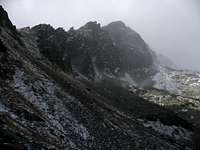 Ostrá veža how it truly is - scary and magnificent.
 Sedielkova kopa on the left, Krivan in the back and Ostrá veža on the right
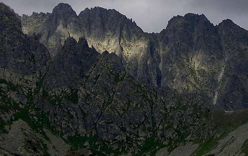 Ostrá veža in the centre, Solisko ridge behind.
 overview and the most detailed description of Ostrá veža massif (numbers 12-20) from east. The eastern walls are 150-180 meters high.
 overview and description of massif of Ostrá veža (numbers 10-14) from west
 map - diagram of ridges with drawed marked hiking trails.
 map of Ostrá veža with its surroundings
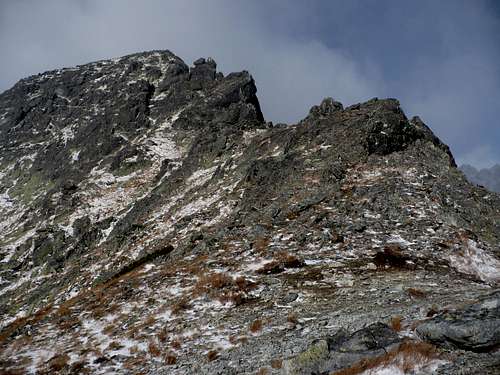 south ridge
 The place on the trail, from where Ostrá veža is the most impressive.
 Also availability of hiking trails is limited - most of them are usable yearly only from 15th june till 31th october.
 Chalet under Solisko - only hour away from Ostrá veža.