Preamble
Once upon a time, EastKing lived in New Hampshire. That's where I met him - or rather, thanks to SummitPost I met him on a trail in New Hampshire. He has been living in Seattle for, I think, about a year now, but hasn't changed his 'nym.
Part 1: Not Trespassing on Tinkham
Of course my flight was delayed two hours by thunderstorms. I arrived in Seattle at 2AM, didn't get to sleep until 4:00. A few hours later EastKing was laying out options for a local warm-up hike. It couldn't be too big or too far since he'd have to be back to work another night shift, but I sure wasn't feeling ambitious anyway. He indicated that Tinkham Peak was the easiest one he had in mind, and I sprung for that one right away.
Tinkham is about 5,400 feet tall, which in the Northeast would put it in the top four or so. So I wasn't too worried when EastKing described the hike as a "dumpster dive", said the views would be nothing special, and even warned me, "once you see the North Cascades you're gonna hate me for having taken you up Tinkham."
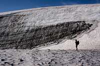
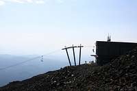
![trail]() just below Tinkham
just below Tinkham
The future could sort itself out later; meanwhile I got behind the wheel of my rented Kia Rio and headed out interstate 90. If I kept going on this highway, I could probably get to work on time for Monday, but work was the farthest thing from my mind. As we drove along I tried to guess the heights of the peaks I could see (I was usually wrong - the trees out here are so much taller it messes with your sense of scale), while EastKing complained about the haze that was obscuring the views. It wasn't particularly hazy by New England standards, but it was scorching hot. This summer, while Boston has mostly seen rain and temperatures in the 70s, Seattle got record 100-degree heat. The sun beat down hard when we pulled into our parking spot on a dirt road by the Pacific Coast Trail. I stripped and put on sunscreen; EastKing did likewise and opted to use his shirt as a couvre-chef.
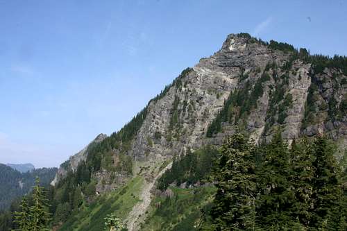
![silver peak]() Silver from Tinkham
Silver from Tinkham
We entered blessedly shady woods once we stepped onto the trail, which was wide and smooth. At a cairn we turned onto a trail that was nearly as large, and started gradually gaining altitude. A few rockslides came into view, and I picked up a rock fragment. It was some kind of conglomerate, but solid enough that I couldn't easily break it. That was a good sign.
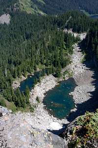
![looking straight down]() view from tinkham
view from tinkham
After a some walking (western trails are full of unnecessary switchbacks, which makes them quite restful to climb), we reached the col between Silver Peak and Tinkham. The main trail headed for Silver; the branch path to Tinkham was narrow, but remained quite obvious. Aside from the bootprints, on the left side of the col was a cliff, and on the right side of the col was the Cedar River watershed, marked with No Trespassing signs every few yards. The path usually used the signs as blazes, passing inches away on the legal side.
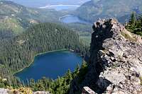
![lakes]() Tinkham E peak and view
Tinkham E peak and view
Just below the peak we emerged from the woods and engaged in a bit of scrambling. There's a traverse of a gulley (narrow and exposed but almost class 2), and then a short upward scramble. The scramble wasn't difficult, but the trodden path was littered with loose dirt and rock fragments, with few solid handholds in case of a slip, so we opted for a variation on firmer ground.
Once on top we enjoyed the views, signed the register, and made the easy traverse to the east peak. On the way down we couldn't find the scramble variation we'd used, so we invented another alternate route that made heavy use of tree roots.
Just below the col we met a group of about six people who were on their first hike. I thought they were a little too loud, but they were obviously enthusiastic about the experience. "Wow, look at that mosquito bite!" They were on their way to Silver Peak.
Surprisingly they passed us again before we reached the car: they'd decided to turn back shortly after meeting us. Was it something we said?
Part 2: the tall Sister keeps us up at night
The original plan had called for a three-day expedition to Glacier Peak (it's a long approach). The flaw in this plan was that our planned route involved a full day of glacier travel, and neither EastKing nor I had significant glacier experience. So doing it as a two-man team was out of the question, for safety reasons. (Crevasse rescue is much easier with three men sharing a rope.) At one point it looked like we'd have two three-man teams; as of the Tuesday before my flight we still had a three-man team and I scurried to buy pulleys and prussiks, and borrow pickets, but in the end we had only two of us and we had to pick an alternate destination.
![stream]() campsite stream
campsite stream
It wasn't until we'd been on the road for a couple of hours that it dawned on me that South Sister is a LONG drive from Seattle. No matter, I got to see some scenery (when I wasn't napping): from forests of giant evergreens, to almost-flat plains, to mountains, to the scars of huge forest fires, to dry, sagebrush-studded scrub. The ongoing heat wave was much in evidence; at one point somebody had set up an irrigation system to keep a stand of aspen alive. You know the old cliche about "it's a dry heat"? Turns out there's some truth to it. Ninety-five (35C) in eastern Oregon feels similar to 85 (29C) in Boston: hot, but bearable.
![firefighters]() firefighting
firefighting
Sometime in the afternoon we reached Devil's Lake and picked a camping site in a lava field beside a numbingly cold stream. EastKing was eager for an alpine start at midnight to be on the summit before sunrise. I hate alpine starts, but the daytime heat convinced me, though I still haggled out an extra two hours of sleep. So once the tent was set up, we wasted little time in hitting the sack, pausing only for dinner and to watch a helicopter picking up water in the lake to dump on a nearby forest fire. Eastking has a remarkable ability to fall asleep anywhere and was soon out cold; I lay awake listening to birds for a while but, thanks to earplugs and some chemical aid, fell asleep within an hour or so.
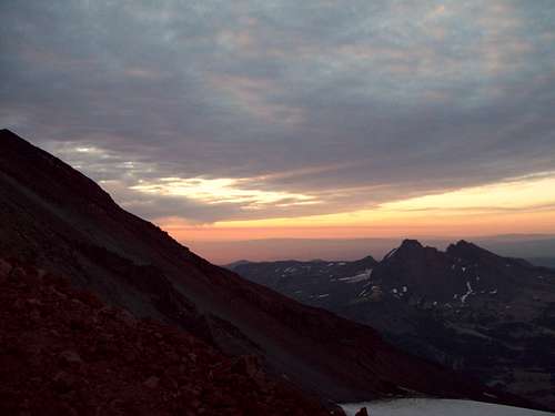
![Broken Top during Sunrise]() dawn at last
dawn at last
When our alarms woke us at 2AM I was surprised to feel - not rested, but not miserable. Except for refilling our water bottles (we'd each consumed about a liter during the night), all our stuff was ready to go. We just put on our headlamps, picked up our packs, and hit the trail.
When refilling my water at the stream I'd thought I'd heard a noise upstream, and now when the trail passed that spot our headlamps reflected a pair of green eyes about a foot above ground level. As I approached, the eyes suddenly lifted to about six feet high, and then we were able to discern the outline of a deer. I tried to get a photo, but it was hopeless. (Partly due to lack of light, partly due to my mental state at 2 AM. I'd left the shutter in timer mode, and didn't notice.)
Hiking in the dark is always disorienting, and I couldn't make much sense of the trail's wanderings as it drifted around in the valley between Devil's Hill and Kaleetan Butte, but at least there was no risk of losing this trail. Once on the ash plateau north of Devil's Hill, and mostly out of the trees, we used only one headlamp at a time.
Treeline in the East is mostly determined by wind: above a certain elevation, trees abruptly get shorter as they huddle in each other's "wind shadow", and soon cease altogether. The whole transition from impenetrable forest through tangled "cripplebush" to alpine tundra usually takes less than a hundred feet of elevation. Out West, "treeline" is a nonsense word. Tree growth is mostly determined by water. Trees are never dense to begin with, and they just gradually get sparser. Even two thousand feet above the forest, all it takes is one little stream and trees can reappear. This is immensely frustrating to Easterners, accustomed as we are to charting our upward progress by the type and height of trees we pass. Those were the thoughts on my mind as we slogged northward toward a shadow above the horizon that we knew was South Sister.
Soon we could distinguish paler spots that had to be snowfields, and then we spotted a light - no two, three, maybe four. Somebody else was climbing the mountain at night, and had gotten a big head start. It looked like at least two parties, one of which might be climbing Lewis glacier. From this distance, they didn't seem to be moving very fast.
![Broken Top]() Broken Top
Broken Top
Eventually we were off the gigantic ash apron and heading uphill over scree and small rubble. At this point we could no longer see the lights above us - the flanks of the mountain hid them. In the dark we nearly wandered off-trail once or twice when footprints diverged to avoid minor obstacles in the form of small snowfields or slab/scree scrambles. Having been hiking for nearly two hours, I insisted on a break for snacks and water. This was a significant role reversal from a hike we'd once done in New Hampshire, when EastKing (fifty pounds heavier at the time) had struggled to meet "book time" while I champed to go faster. This time I was the one calling for a slower pace. "Feeling strong?", Eastking asked me while I sucked on a Gu he'd given me. "Definitely not strong", I replied. "But I'm OK considering it's four in the morning." The jolt of sugar from the Gu made a big difference, and we resumed our previous pace.
![You pick the route]() glad we didn't go that way
glad we didn't go that way
Around 6 AM we could see signs of dawn. We were up beside Lewis glacier now, slogging up a 45-degree slope of loose pumice in noticeably thinner air. The summit was in sight, and we had a chance of making it by daylight, but I was running low on energy again, and starting to feel signs of cramping in my legs. I called another halt and ate some salted peanuts. I urged Eastking to go ahead and bag the sunrise from the top, but he chose to stay with me, saying what he really wanted to see was the shadow of the mountain spreading over the landscape below, and we were on the right side of the peak for that. EastKing started telling me about pressure breathing, the rest step, other stuff I already knew. No need for any of that, I just had to keep my pace a bit slower than I'd have liked.
If you step off-trail you can find your feet rolling downhill on a layer of small pumice stones. It's possible to run uphill faster than the pumice can roll down, but this is not a good idea when you're not acclimated to the altitude.
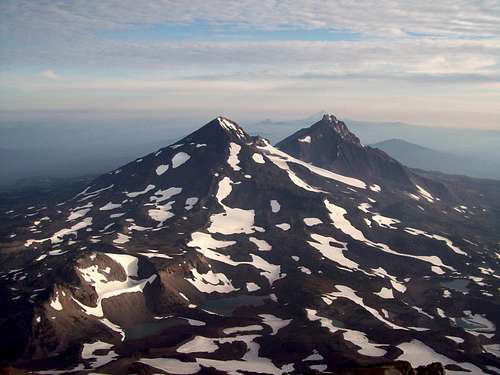
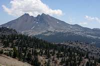
So it was a bit after dawn when we reached the crater rim. The climbers whose lights we'd seen (there were six of them) started passing us here on their way down, as we circled around the crater to the true summit. Four and a half hours up - not too horrible. And the views were great. Middle and North sister almost perfectly aligned in front of us, with other big volcanoes barely visible in the distance beyond them. Broken Top looking almost small (but by no means easy) beneath us. And smaller cindercones everywhere we looked, growing from a landscape of pumice slopes, flattened ash pillows, and black and broken lava fields.
![Middle and North Sister]() The other sisters
The other sisters
Eastking had mentioned that if we did both South Sister and Middle Sister, the total was something like twenty miles and 10,000 feet of gain. That sounded feasible in a day, though we weren't planning to do it that way. So I was curious about the route from South Sister to Middle Sister.
![Inside the Crater]() crater
crater
First lesson: a 3,000-foot col may be entirely feasible, but it looks HUGE in person. Eastern cols are more like 500 feet or less. A long hike involves maybe ten of them in a day, so the total elevation lost and regained is the same, but there's something about actually seeing 3,000 feet of continuous descent that makes me less than anxious to get started.
![descent]() descent
descent
Second lesson: the terrain here is different. I couldn't "read" it at all - cliffs just appeared in places I didn't expect; rock quality changed suddenly without rhyme or reason. I didn't see a way down that I could be really confident would "go" without a rope - and given the rotten rock, a rope might not be much help. Probably there is one (on a map the ridge heading north-northwest looks like the obvious choice, rather than hunting for a route down the north-northeast face like I was trying to do), but I wasn't prepared to make the attempt and risk backtracking all day.
After lazing on the summit for about an hour and completing our circumnavigation of the crater rim (with a detour to the shores of Teardrop Lake) it was time to head down.
![Life on a volcano]() summit life
summit life
For the first time I could see the entire distance we'd climbed during the night. The summit cone was a brick-red heap that seemed to be composed entirely of loose pumice. This cone was mostly bare of snow, except for Lewis and Clark glaciers, which weren't much more than snowfields - Lewis had a significant bergschrund and a bit of a moat, but I didn't see any crevasses. Below the tarn at the foot of Lewis, the landscape turned grey, first rock and scree and then vast almost-flat plains of dusty ash leading down to the lakes.
![Southward view]() boulders
boulders
The pumice at the top looked completely dry, but a few plants proved that some moisture exists. Photographing these plants was not always easy, since my steps could unbalance the slope, uprooting all the life for yards around.
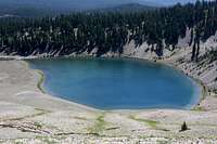
![Moraine Lake]() Moraine Lake
Moraine Lake![Broken Top]() Broken Top
Broken Top
Low on the summit cone, large basalt boulders were mixed in with the pumice, seemingly at random. The difference between pumice and basalt is amazing: pumice weighs vastly less than any other type of rock. So though it provides an excellent texture for gripping, and is not particularly fragile, you have to be extremely careful when clambering over pumice: blocks that look big enough to support an army will tip and roll under your weight. Basalt requires equal caution, but for opposite reasons: immovably heavy, it is smooth to the point of slipperiness and sometimes hides fracture lines that result in chunks breaking loose unpredictably. Here on the volcano, for the first time, I was seeing intermediate forms: boulders that were solid and smooth at one end but foamy at the other.
![South Ridge route]() our route
our route![Indian Paintbrush]() castilleja
castilleja
Below the cone the rock changed color to a light grey, like limestone, and additional wildflowers like indian paintbrush and lupine began to appear. The trail was mostly scree now, with one slabby section we recognized from having momentarily lost the trail on the way up. Below this, small stands of trees began, and then the landscape changed again to a nearly flat plain of old ash. Off to the side we could see jagged lava flows, with the volcanos looming high above them. At one point there was Moraine Lake, glittering emerald below us.
Finally we entered a true forest in the shadow of Devil's Hill. Here we met a fire crew, and followed them down to the trailhead. (Actually they let us pass at first, but soon caught up to us, so we let them lead from then on.) A woman at the end had come kind of net tossed over her shoulder, with a heavy metal hook that clanked as she walked. In the front, a man was improvising drumbeats on a cardboard box (I think it had contained drinking water in a plastic bag). It felt like a parade, and I silently thought the lyrics (the ones I could remember, anyway) to "Johnny comes marching home".
Finally we were back at the tentsite. EastKing went to sleep almost immediately, while I went to soak in the cold lake.
part 3: an ugly Bachelor
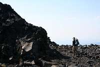
![Bachelor peaks]() false-summit scramble
false-summit scrambleIt hadn't taken us long to decide that we'd be miserable doing another alpine start, climbing Middle Sister, and driving back to Seattle all in one day. So the back-up plan, which we'd been discussing ever since leaving Seattle, was to get some sleep, do a morning hike up Mt Bachelor, and get out of Dodge in the early afternoon. This plan had the additional advantage that the trailhead was just up the road, so we could leave our tent in place and come back to tear it down after the hike -- again allowing us more time to sleep.
![Bootstrapping]() summit lift
summit lift
After a brief delay searching for a nonexistent roadside trail sign, we parked at the gate of the ski area and soon found the hiking trail leaving the parking lot. The trail started in woods so spacious I wondered why anybody bothered cutting ski trails. The trees quickly thinned, and we were slogging up a volcanic wasteland in the hot sun. In addition to the ashen desolation of the volcano itself, the trail stayed within spitting distance of the chairlifts. So though we frequently had good views toward the Sisters, it felt a bit like an industrial site. Aside from some California jays and some crows, we saw no animals.
![succulent]() summit life
summit life
Correction: we saw some humans in pickup trucks pulling into the halfway chairlift station, and we saw them again when they reached the summit, riding in the chairs. They were using the chairlift to deliver a crate to the summit lift station. The crate, we deduced, had been delivered to the base lodge by helicopter.
![lichen]() lichen
lichen
Also on the summit were some birds with slighlty irridescent-blue wings, that I haven't identified.
The summit area is somewhat marred by a bulldozed ski trail, the exact highpoint (we think - there were several candidate boulders) is roped off, and there was plenty of broken glass, old steel wire, and other unwelcome signs of humanity all around the summit. At least there were good views in all directions, though the air was hazy. And we did some fun scrambling to reach a couple of the false summits.
On our way down we passed a few people on their way up (including a jogger wearing black and carrying no water). Back at the parking lot we paused to gawk at the helicopter that was ferrying gear, and paused again to watch a raincloud build to threatening heights before passing harmlessly over the peak. (We'd previously joked about how trip reports describing lightning strikes make the best reading.) Then it was back to Devils Lake to strike camp in preparation for a very long drive back to Seattle.
Part 4: Dickerman struts its stuff
Eastking went back to work and I had about 48 hours before I'd have to catch a flight. My plan was to hike Mt Dickerman and then play it by ear. The main reason for picking Dickerman is that several SP members had recommended to Eastking. A nontechnical hike, easily feasible as a daytrip, with foolproof directions to the trailhead thanks to its Summitpost page - perfect.
Well, the foolproof directions weren't quite foolproof (but don't worry, the SP page has been corrected). I was looking for the trailhead almost two miles before I should have been. Luckily I parked on the main road and checked out the small dirt roads on foot - I wouldn't have been able to turn around on some of them. The correct trailhead has a huge parking area and a sign, so once I found it I knew I was in the right place.
It was late morning when I started up the trail. Almost immediately I slowed down to take photographs. Aside from the gigantic trees (whose scale I never managed to capture in a photograph), there was a profusion of berries, some unfamiliar ferns, and so on. Near the trailhead a crew was putting a bed of level gravel in a stream crossing. To me their work looked both totally unnecessary (the crossing was already very easy) and probably futile (if springtime in the Cascades is anything like New England, the gravel will probably wash away in a year or two), but I said nothing, just smiled a greeting and nodded politely when one of them warned me to watch my step in the work zone.
After that I was largely alone, though sometimes I could see and hear a couple with a dog who had left the parking lot right behind me. The trail made large zigzags up a steep slope, so if I had waited for them to get a little closer, I could have tossed a rock onto their heads. The trail could have been designed for fortification. I occupied my thoughts with tactics (what if the attackers had a light mortar?) while striding easily along the trail which, thanks to the giant switchbacks, had very little grade.
After a while the trail heads towards a cliff. It crosses under it and skirts the left side. Just as you're resigning yourself to an Eastern-style uphill slog along the cliff's edge, the trail swings wide left, into a small meadow. That meadow leads to another meadow, and then another, and soon you're strolling through wildflowers, gazing at nearby peaks, and generally feeling as much like Heidi as is possible without wearing a dirndle.
The hike is not over yet, however. Having swung off to the west, you reach a ridge and see the backside of Dickerman: a cliff many times larger than the one you've already bypassed, extending from the summit to a point far below you. The trail follows the ridge toward the cliff edge only briefly, then traverses to the right to find easy slopes all the way to the summit.
![Dickerman]() backside of Dickerman
backside of Dickerman
Nothing exciting happened to me on the summit, but since this is SummitPost I feel like I should say something climactic. At the very least I should balance out all those berries and flowers with some scenery photos. Unfortunately it was a bright, hazy afternoon, terrible conditions for photography. The Mt Dickerman page already has a lot of photos of the views, many of them quite good. So here's just a taste:
![Mt Baker through haze]() distant peak peek
distant peak peekSurprise Ending
After hiking down from Dickerman, I needed to find a place to spend the night. I also needed to come up with a short hike I could do in the morning, allowing me to get back to Seattle in plenty of time to catch my flight, preferably meeting up with EastKing and his wife for dinner first. Of course I had no cell phone reception, so dinner details would have to be worked out later. Meanwhile I went driving around looking for a campsite. (No map. Stupid, but there were lots of campsites along the road on the way in. ) I proceeded north on Mountain Loop highway for a few miles. Just I was getting nervous about my near-empty gas tank (now that was truly stupid), the road came to a fork: the left branch was a dirt road, and the right branch was gated. As I hesitated (dirt roads rarely lead to gas stations) I noticed a few mountaineers walking up the closed road to their cars which they'd parked by the gate. I got some advice: no gas until the next town (I forget the distance, but enough to make me uncertain about getting there on an empty tank), no developed campsites. Back-country camping was an option: one of them mentioned that there was a reliable stream about a mile down the closed road. But it was getting a little late, and I wasn't in a mood to take any kind of risk, and I worried about not finding a good camping spot. (I'm not usually that pessimistic, but I like to limit the number of known problems I'm facing, and my lack of planning regarding map and gas tank had eroded my mental margin of safety.) So I decided to head back the way I'd come, knowing I'd find campsites, and minimize the amount of driving I'd need to do to reach gas. I also was curious to see the Ice Caves at the foot of Big Four Mountain, which looked like a short, very easy hike, ideal for a lazy morning before returning to Seattle.
![Bobwhites]() Bobwhites of fate
Bobwhites of fate
I passed a couple of reservation-only campsites, and then, as I was cruising slowly along the road, I saw some kind of grouse in the drainage ditch. Luckily there was a turn-off just ahead, so I parked there and stalked back to try to photograph what turned out to be a couple of bobwhites. The birds proved skittish, but when I returned to my car I realized that I'd found an ideal camping spot: the turn-out was a small parking area, mostly full of stacked lumber. There was a tiny cabin that, upon investigation, was an out-house. There was fresh toilet paper, so it must be a legal site for camping. Strangely, metal door of the outhouse had some disconcerting dents, like someone had attacked it with an axe, but I didn't give that a second thought. In the woods nearby were some fire rings. I pulled my car deep into the driveway so that it was almost entirely hidden from the road (it certainly wouldn't be visible at night), picked a spot in the woods that was far enough to be hidden but easy for me to find if I needed to navigate to and from the out-house, set up my tent, made my dinner, and laid down to sleep.
![surprise!]() rude awakening
rude awakening
Sometime later I woke to the sounds of a drunken argument. An indeterminate number of youngsters had decided to hang out on the stream bank close to the road. They hadn't noticed me and with luck, they hadn't seen my car, and I decided to ignore them, even though one of them was using an axe to hack senselessly at the logs, which was even noisier than the screaming match that had woken me up.
A few hours later the noise hadn't diminished, so, taking a roundabout route, I found the one with the axe, gave him a little startle, and asked him to knock off the noise. He seemed drunk and/or high, and also was clearly trying to concoct some kind of alibi, but I told him I wasn't a cop, I just wanted them to knock off the noise, in particular the chopping. Then I slipped back into the woods. The group was quieter after that, but I put my earplugs in anyway, and fell asleep.
In the morning the youngsters and their tent had vanished. As I approached my car everything seemed normal at first - but then I had an awful moment of doubt about the windows. The reflections didn't seem quite right. Sure enough, they'd been smashed in. Also the trunk had been opened, but not much was stolen, just my microspikes and my climbing harness (with various climbing gear attached). Instead of a leisurely hike to the Ice Caves, I realized I had a full agenda. I first flagged down a car and hitch-hiked to the ranger station, where I called the sherriff. I ate breakfast while waiting for the sherriff to arrive. When the promised forty-five minutes had been largely exceeded, I hitch-hiked back to the car, pulled out the remains of the windshield with my ice axe and some help from the folks who'd given me a ride, drove the car back to the ranger station, called the sherriff again, called the car rental agency, called AAA, called the car rental agency again, called my credit card company (I'd declined the rental LDW), left a couple of messages for EastKing, filed a report with the sherriff's deputy when he showed up, rode back to Seattle in the tow truck, filled out forms at the rental agency, and got a ride to the airport.
EastKing and his wife did manage to meet me in the airport before I had to board, but I still owe them dinner.


Comments
Post a Comment