
|
|
Area/Range |
|---|---|
|
|
42.31388°N / 116.23535°W |
|
|
Hiking, Bouldering, Scrambling, Canyoneering |
|
|
Spring, Fall |
|
|
Overview
The Owyhee Canyonlands of southwest Idaho, southeast Oregon, and northeast Nevada are one of the most remote and inaccessable areas of the continental US. This is an area filled with sagebrush and juniper covered deserts, beautiful mountains, hoodoos and natural arches, and incredible river canyons carved into the ancient rhyolitic lava flows characteristic of the area. One who is used to the more visited areas of Idaho and Oregon might not believe that such a place could exist in these states filled with vast evergreen forests and snowcapped mountains.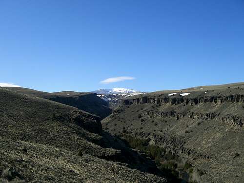 Jarbidge Headwaters
This area is contained within three gigantic counties, Owyhee County, Idaho, Malheur County, Oregon, and Elko County, Nevada. Owyhee County is characterized by vast sagebrush deserts crisscrossed with the deep river gorges carved by the Bruneau, Jarbidge, and Owyhee rivers and their tributaries. The Owyhee Mountains run north-south parallel to the Idaho-Oregon border. Malheur County, Oregon is more sagebrush desert but contains the majority of the main Owyhee River Canyon. Elko County, Nevada is home to the impressive Jarbidge Mountains and the headwaters of all three of the major rivers that form the Owyhee Canyonlands region.
The Owyhee country is best divided into East and West sections. The East section contains the canyons of the main Bruneau with its East and West Forks, the Jarbidge River Canyon, Sheep Creek Canyon, and Jack's Creek Canyons. The 10,000 ft. peaks of the Jarbidge Mountains in Nevada form the southern boundary.
The West Section contains the Owyhee River Canyon with all the canyons of its tributaries as well as the Owyhee mountains of Idaho. The West section is the more visited of the two but the East is no less impressive or harsh.
All of the public land is administered by the BLM except for the Jarbidge Mountains which are administered by the Humbolt-Toiyabe National Forest.
The Duck Valley Indian Reservation straddles the Idaho-Nevada border and is home to the Northern Piute.
Wilderness
The oldest wilderness area in this region is the Jarbidge Mountain Wilderness in Nevada. It was established in 1964 and was Nevada's first wilderness area. In 1989 it was expanded and now encompasses 113,000 acres.
Most recently, the Owyhee Canyonlands initiative was passed by the US house of Representatives on March 25, 2009. It was passed by the Senate a few days earlier and was signed into law by President Obama on March 30, 2009. This initiative is a product of 8 years of study and negotiation beween conservationists, long-time ranchers, and recreationists. It designates 517,000 acres as the Owyhee-Bruneau Wilderness in six units and releases another 199,000 acres for non-wilderness multiple use. There will also be 316 miles of river added to the Wild and Scenic Rivers system. The bill was sponsored by Sen. Mike Crapo of Idaho.
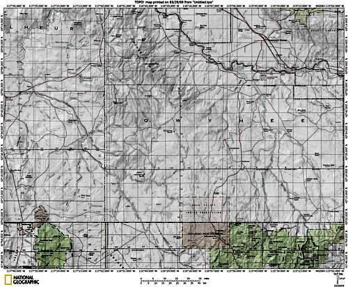
Here is a map of the new wilderness areas in the Owyhee Canyonlands.
 The Jarbidge Mountains
History
The Owyhee region shares much in common with the history of the Western US. It is a history full of trapping, mining, cattle ranching, and land use disputes.
Owyhee County
Owyhee County was the first county formed by the new Idaho Territorial Legislature in 1863 and encompasses 4.9 million acres.
 Zeno Canyon
Two things have always dominated Owyhee County; Ranching and Mining. The first ranches were established in the late 1800's and many of them remain in the same families being worked by each generation in succession. Since the time the ranches were established, much of the land has suffered from overgrazing. For anyone who ventures into the Owyhee Country you can rest assured that you will see cattle. The canyons are usually free of cattle simply because they are inaccessible except by water.
The majority of Owyhee County's mining activity has taken place in the Silver City area located in the Owyhee Mountains. Gold and Silver was first discovered in the area in 1863 and by 1866 82 stamp mills were producing $70,000 a week. Silver City quickly became one of the largest cities in the Idaho territory and the county seat of Owyhee County. However, by the mid 1930s Silver City was little more than a ghost town and the county seat was moved to Murphy. All-in-all the mines near Silver City Produced nearly $40 million in gold and silver. For more information on this visit the SP page for the Owyhee Mountains.
Elko County
Elko County is the 4th largest county in the US but the part I've chosen to include in this page is the extreme northern portion containing the Jarbidge Mountains and the headwaters of the Owyhee, Jarbidge, and Bruneau Rivers.
 Hoodoos Near Jarbidge
The Jarbidge Mountains are the highest mountains in this area with 8 peaks topping 10,000 ft. The highest peak is called the Matterhorn and rises to 10,839 ft. The central and highest portion of this range is encompassed by the Jarbidge Wilderness. Visit this site for more information on the Jarbidge Mountains.
The town of Jarbidge is one of the most isolated towns in the the continental US, being hundreds of miles and hours away from any sizeable town with even so much as a hospital. There are no paved roads leading to the town and it sits in the bottom of the canyon formed by the West Fork of the Jarbidge River. It was the scene of a gold rush starting in 1909 and lasting til 1935. In 1916 the nation's last armed stage robbery occured near here.
Malheur County
Because I don't know a whole lot about this county I've referred you to this webpage about Malheur County History.
Climate
This region is a vast desert with very little precipitation. Temperature varies with elevation and elevations in this region range from just under 2,000 ft. near the Snake River to near 11,000 ft. in the Jarbidge Mountains. Most of the snowfall in this area is concentrated in the Owyhee and Jarbidge Mountains. The lower elevation plains and canyons do see some snow in the winter but it usually doesn't accumulate much. The summer can be brutally hot with temperatures exceeding 100 degrees. It will be cooler higher up in the mountains though.
 Red Rocks
The ideal time to visit the canyons is in the spring or fall so as to avoid the heat.

Current Conditions

Getting There
 Owyhee Map
US highway 95 provides access to the Oregon portion of the Owyhee River and runs South along the western edge of the Owyhee Mountains and through the beautiful Jordan Valley of Oregon.
 Clover-Three Creek Road
ID 78 from Marsing, Idaho to Glenn's Ferry, Idaho provides access to the Siver City area as well as Bruneau Dunes State Park and northern Owyhee County.
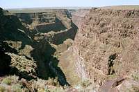
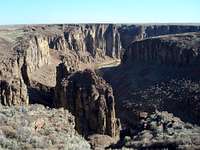
Accessing the Bruneau-Jarbidge area is another story. The shortest route to this area is to take Hot Springs road south from Bruneau, ID. It will eventually turn into the Clover-Three Creek Road and run all the way to Murphy Hot Springs, ID and Jarbidge, NV. the road is paved for about ten miles South of Bruneau and then it becomes a dirt road for the rest of the distance before it joins the Three Creek "highway". This road will take you past the Bruneau Canyon overlook but don't expect to get down into the canyon here since it is 800 ft. deep and 1300 ft. wide at this point.
 The Bruneau Canyon
The fastest route to Jarbidge, NV is probably from Twin Falls, ID. Take US 93 South to Rogerson, ID then turn West onto the Three Creek Road ("highway"). The road is paved until a few miles outside of Murphy Hot Springs. Be prepared to see antelope and incredible views of the Jarbidge Mountains. This road will take you to the confluence of the East and West Forks of the Jarbidge River. Exploring the canyons downriver from that is up to you as hiking trails in the canyons are basically nonexistant. There are trails that lead into the canyons but not along the rivers. If you want to hike down the canyons it will be a cross country journey and you may have to get your feet wet when the canyon walls close in.
The best way to explore the canyons is by raft or kayak, but be warned that these rivers are not for novices. All of the rivers are full of class III and IV water with a few class V rapids which make them appealing to advanced rafters and kayakers. Once again, if you get into trouble on the river chances are no one will be around to help you.
The access roads that lead to the canyons are well signed by the BLM so the only difficulty lies in the road conditions which vary with the seasons.
 Little Jack's Creek in Fall.
Red Tape
 Bruneau Canyon
 Jarbidge Hoodoo.
Another thing that must be taken into consideration is the lack of services. There is gas in Bruneau, Grandview, and Marsing,ID along ID 78. Jordan Valley, OR has gas on US 95. Once you go south services start to be few and far inbetween. I'm not sure whether Riddle or Gransmere, ID have gas along ID 51. There is NO gas on the Clover-Three Creek Road. There are NO services in Murphy Hot Springs and limited services in Jarbidge, NV. There is gas sometimes during certain times of the year in Jarbidge.
If you venture into this area be prepared for anything. If you get a flat, run out of gas, or have other problems you'll probably have to be the one that takes care of it because chances are you'll be alone.
This is a desert so bring plenty of water. When exploring the canyons though, you'll always have a river with you so bring a
filter.
Also, once you're in a canyon the only way out is at either end unless you have climbing equipment.
 East Fork Owyhee River
 Oregon Honeycombs
The water levels of any of the rivers can fluctuate rapidly without any notice so be aware of the weather upstream. If it's a downpour up there you may be in for a flash flood.
Camping
 Zeno Falls
External Links
Northwest Canyoneering This is a really cool site with some great photos of many of the slot canyons in the area.Humbolt-Toiyabe National Forest Jarbidge Ranger District.
BLM Owyhee Field Office.
BLM Bruneau Field Office.
BLM Jarbidge Field Office
Information regarding the Owyhee Canyonlands Initiative.
Bruneau Dunes State Park
A link to the Owyhee Initiative home page.
This is an amazing site that features interactive tours of the area's canyon lands.
Here's a pretty cool video from Oregon Field Guide about rafting the Owyhee River. (Contributed by calebEOC )
Finally here's the Outdoor Idaho episode about the area.
bubbaruns - Apr 10, 2010 11:25 pm - Voted 10/10
video location correctionJust wanted to point out the Oregon Field Guide video is about floating the Middle (portion) of the Owyhee River, not the Middle Fork, which ofcourse is a different canyon. happy trails, Glenn (bubbaruns)
mtybumpo - Apr 11, 2010 11:26 pm - Hasn't voted
Re: video location correctionOk I'll get it fixed. Thanks!
thecat - May 15, 2017 1:29 am - Hasn't voted
LinksJust tried a bunch of your external links and most of them seem to be URL Not Found